|
Low-Frequency Radio Ranges
Tom Johnson
The article I wrote for the July, 2009 Touch & Go, "Airway Light Beacon Archaeology," explained my interest in finding the remnants of the beacons that guided pilots at night from the late 1920?s into the 1950?s. During that same period, pilots were guided in instrument flight, and in daytime visual flight, by the Four-Course, Low-Frequency Radio Range. The beacons and radio ranges were the navigation aids (or navaids) that were indispensable in enabling the airplane to evolve from being a marginal, fair-weather, daytime-only supplement to America?s transportation system to becoming a major, all-weather transportation provider in the course of 20 years.
The first experiments in using radio for both air navigation and two-way communication were conducted by the U.S. Air Mail Service in 1919 and 1920 but were soon discontinued. The establishment of the Aeronautics Branch in the Department of Commerce in 1926 brought renewed efforts in radio communication and navigation. The first seven two-way communication stations, developed by the National Bureau of Standards, were installed by October, 1928. That system expanded to 68 stations, spaced approximately 200 miles apart, by mid-1933.
The Low-Frequency Radio Range (LFR), also known as the Four-Course Radio Range, the A-N Radio Range or the Adcock Radio Range, was developed in the late 1920?s after some unsatisfactory experiments with navigation by both ground-based and airborne radio direction finding. One account attributes development of the LFR to radio engineers of the National Bureau of Standards, borrowing from European systems with improvements contributed by the U.S. Army Signal Corps.1
Another account states: "Late in the fall of 1926, the Ford Motor Company was engaged in ferrying air freight between its Chicago and Dearborn airports. The first of the famous Ford Tri-motor planes was placed on this run early in 1927, and it was in this year that a young Ford radio engineer named Eugene S. Donovan patented the first four-course, loop-type, low-frequency radio range. Two of the radio ranges were installed by the Ford Co., one at their Chicago Lansing Airport and one at the Dearborn Ford Airport. Both proved quite successful in improving the bad weather reliability of the cargo flights. The following year, after intensive and exhaustive tests, the Federal Government began installing a vast chain of LF/MF ranges crisscrossing the Nation to provide radio highways of the air. For each installation patent permission was given, without royalties, by the Ford Motor Co. so that these ranges could be installed in the public
welfare.2
Irrespective of how the LFR was developed, it was soon considered "indispensible" to the development of aviation. Some who considered Ford the developer of the radio range proclaimed it to be a more significant contribution to aviation than Ford?s famous Tri-motor airplane.
The four-course radio range used two loop antenna systems to transmit two overlapping figure-eight patterns.
Transmission frequencies were in the 200 to 410 kHz range with some military LFR?s operating at as high as 536 kHz.
One pattern transmitted a Morse code letter A (? ? ) and the other, with the pattern oriented at approximately right angles to the first, the code letter N (? ?). The timing of the code transmissions was such that when the two transmissions were received with equal strength, where the two directionally-transmitted patterns overlapped equally, the interlocking A and N code tones produced a steady tone. These four areas, each about three degrees wide, defined the four courses or "beams" of the station. A complete description of the LFR and how it works, with sample audio recordings, may be found in the online
Wikipedia article titled "Low-frequency radio range." Another article about the LFR and a new high-frequency re-creation of a LFR in Tennessee may be found in Barry Schiff?s Proficient Pilot column on page 30 of the June, 2010 issue of AOPA Pilot magazine. The article is available to all at the AOPA.org website. Search for "Play it by ear" then click on "AOPA Online: Proficient Pilot."
The beams of the Low-Frequency Radio Ranges defined the airways of the 1930?s to 1950?s, designated Red or Green for east-west routes (airway Green 3 extended east from Oakland to Newark, NJ) and Amber or Blue for north-south airways. At their peak, in the mid to late-1940?s there were over 440 LFR sites in the 48 states, Alaska and Hawaii. By August, 1960, installation of the VHF omnidirectional radio range or VOR had reduced the number of LFR sites to 258. Some LFR?s were converted to non-directional (radio) beacons or NDB?s using the one central antenna tower of the previous LFR. The last remaining LFR?s were shut down in the 1970?s.
Searching for vestiges or remains of the low-frequency radio ranges, I determined the first task of a "LFR archeologist" is to find where the ranges had been located. The best sources of approximate locations are aeronautical charts of the 1930?s to the 1950?s. Many of these charts, especially from the World War 2 years, are available on eBay because so many were produced for pilot training. Another good source, given to me by an instructor at Utah State University in 1961 is the August, 1944 issue of the Army Air Forces Radio Facility Charts booklet that includes the latitudes and longitudes of all LFR stations.
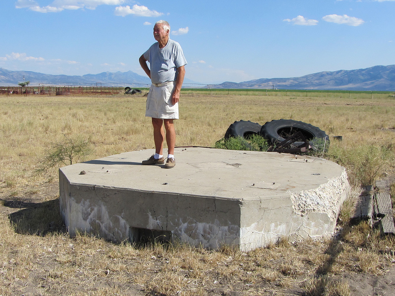
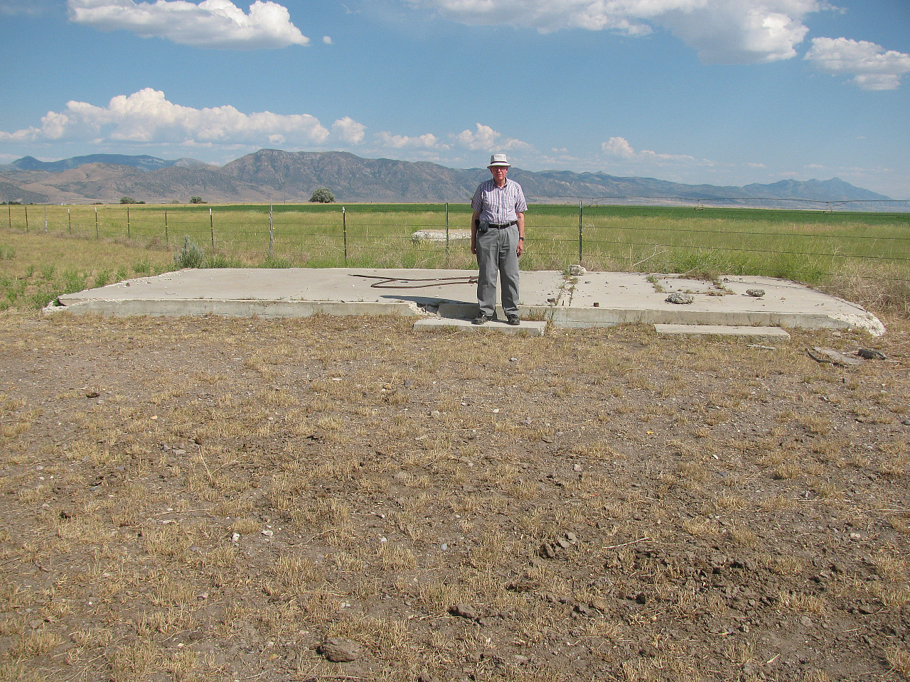
From the chart?s approximate positions it is often possible to determine an exact position using a National Geodetic Survey online search tool to find possible survey marks. This process found precise survey marks still on record for 10 of California?s 35 LFR sites. An online search of topographic maps located 8 additional LFR?s, six on the large-scale (1:24,000) maps. Searching the area on Google Earth and Bing Maps aerial photos has sometimes, when structures have be undisturbed, been the only means of exactly locating a LFR site. This is possible since, unlike the case with airway beacons, most LFR installations covered a 600 by 600 foot or 8+ acre site. On the site there were typically five approximately-120-foot antenna towers, mounted on concrete bases, plus a central building housing the transmitter and a standby engine/generator set. One tower was at the center of the site near the building with the other four towers at the edges of the square area.
The next, and potentially most-exciting, step has been to search the aerial photos to see if any features of the LFR still remain today. In the greater Bay Area, ranges were located at near the Hamilton, Moffett, Oakland, and San Francisco airfields. At Hamilton, the range was later converted to a non-directional radio beacon and the central building and center antenna tower are still standing. Aerial photos (search lat/lon: 38 05.50, -122 30.48) also clearly show the bases of the four outlying antenna towers. The Oakland site, west of Doolittle Drive and north of the north field or original airport, has not been reused and the concrete foundation slab of the central building can be seen in aerial photos. Exploration at the site, on the ground, revealed electrical junction boxes, partially-buried wiring extending to an outlying antenna tower site and broken red glass from obstruction light covers. It was impossible to determine exact locations of the San Francisco and Moffett sites and, in any event, the areas appear to have been reused or built over.
Features of seven other California LFR sites are still visible from the air! The most intact site, which is possibly the most-undisturbed in the nation (!), is near Fort Jones, about 31 miles WNW of Mount Shasta and 31 miles south of the Oregon state line. The aerial photo shows the central building and four of the five antenna towers still standing. After driving by on a trip to Seattle, I made contact with people in the local Scott Valley Pilot?s Association to arrange a visit to the LFR site. They were very hospitable and arranged with the property owners for a visit to the site in exchange for my speaking about airway beacons and low-frequency ranges at their monthly barbecue. The ranch owner related that when the CAA had leased the site in the 1930?s his father had signed an agreement that the government would remove all structures when they were no longer used. When the range was shut down in 1965, however, the FAA offered a new agreement that, in exchange a small payment, the government could simply walk away. Hence, we have a unique piece of aviation history in far Northern California!
Another case of "walking away" appears to be at the Whitmore LFR site, in a very rural area about 18 miles east of Redding, CA. This range was commissioned in 1944 and, apparently due to the efforts to conserve steel during WW2, used wood utility poles for antenna towers. A number of the pole-to-pole antenna wires were still in place when I visited the site 64 years later! Another northern-California LFR commissioned during 1944 served the Alturas Army Airfield. The Google Earth/Maps view (search lat/lon: 41 34.688, -120 42.922) clearly shows the Alturas central-building (or its slab), the five antenna-tower bases and even the supports for the cables from the central building to the towers! At Red Bluff, as at other locations, the central antenna tower is currently used by a non-directional radio beacon with the concrete bases of the four outlying antenna towers still in place in an open field. At some similar installations, such as Miles City, Montana, today?s radio beacon still operates on the same frequency as the 1940?s range station!
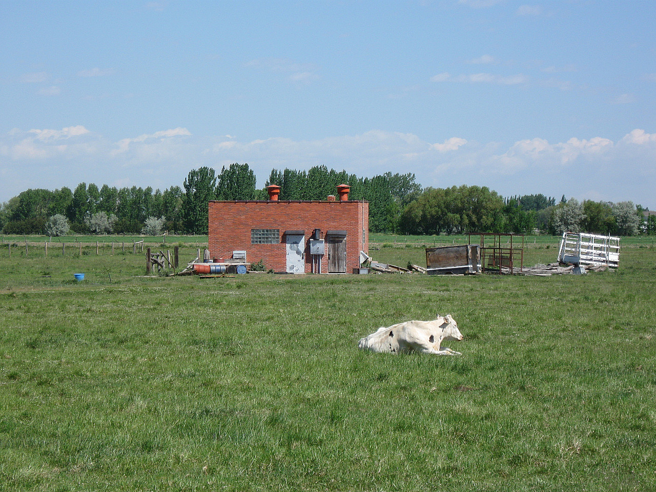
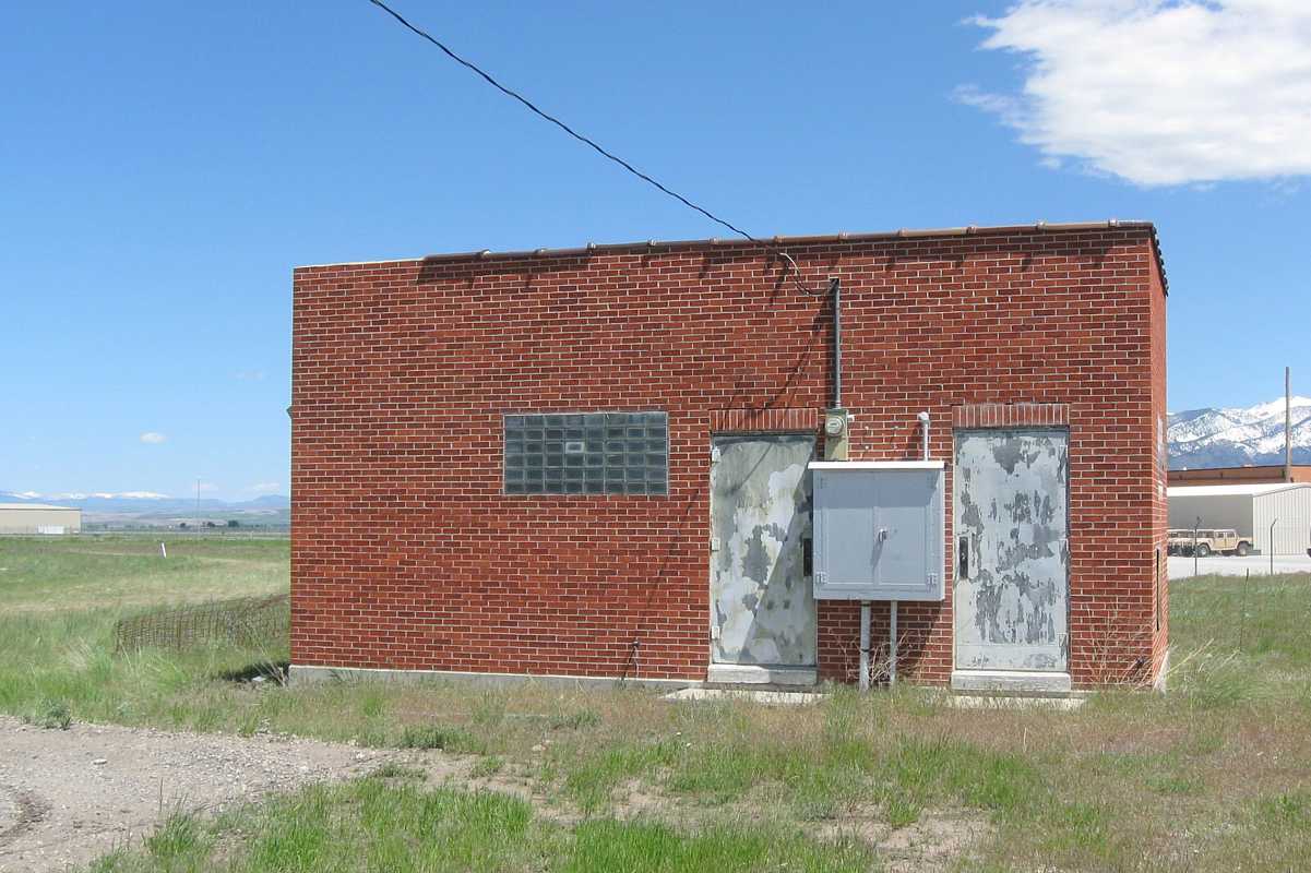
Driving to Montana in 2008 to explore airway beacons and discuss their current use in the state with Montana Aeronautics Division people in Helena, I was able to explore seven LFR sites in Montana, Idaho and Nevada. Five sites had red brick central buildings with glass-block windows, a 1930?s architectural fad. The site at Whitehall, Montana had interesting wood-post cable supports between the central building and each of the five antenna-tower bases. At Bozeman, the red-brick central building is easily accessible on the property of today?s airport.
On a 2009 trip to Utah, I explored the LFR sites at Fairfield, Plymouth, Salt Lake City and Wendover. At Wendover, I thought I would be able to walk about 100 feet across the salt flats to the base of an antenna tower but, on the first step, I sank ankle-deep into the "slush" beneath the surface! In the summer of 2010 I hope to visit seven sites in California, Oregon, Washington and Wyoming.
Notes:
1 Komons, Nick A. Bonfires to Beacons: Federal Civil Aviation Policy under the Air Commerce Act, 1926-1938. Washington, D.C.: Smithsonian Institution Press, 1989 (page 155)
2 Pilots? Radio Handbook, C.A.A. Technical Manual No. 102. Washington, D.C. U.S. Government Printing Office, March, 1954 (page 44)
|
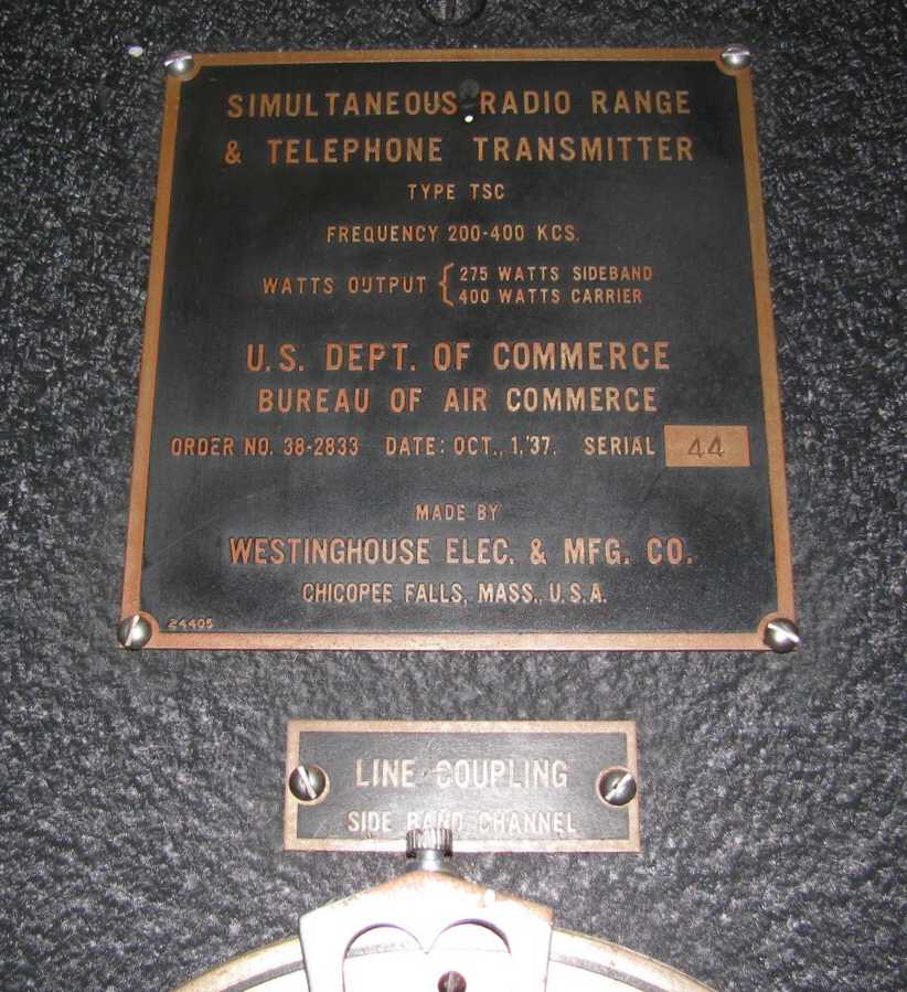
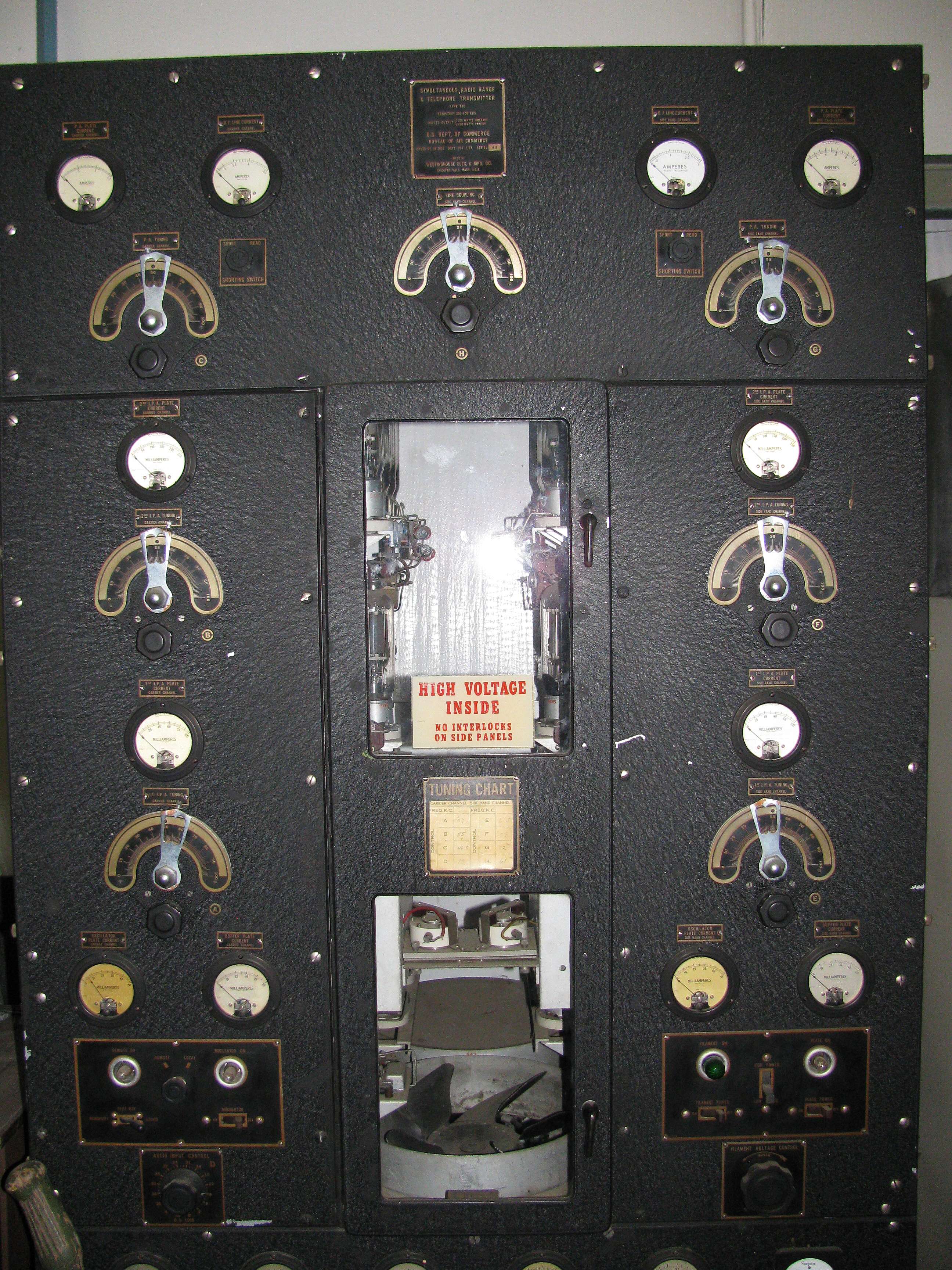
Old Transmitter, November 10, 2010
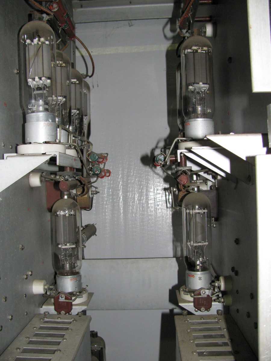
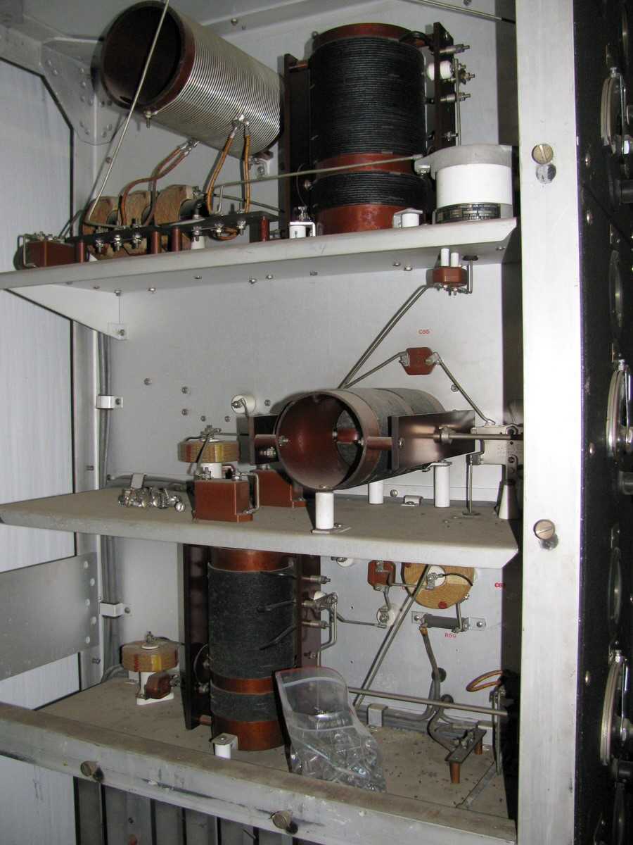
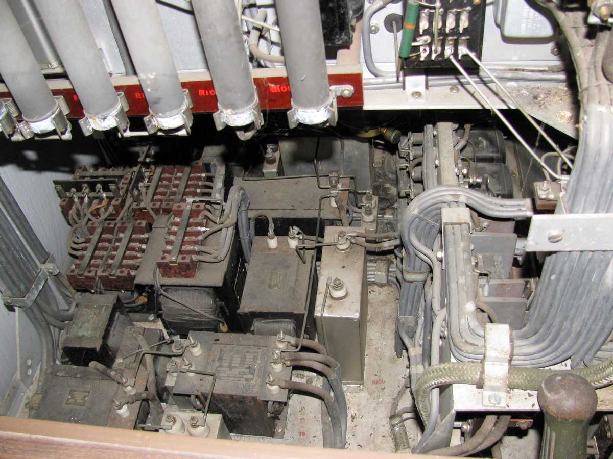
Simultaneous Radio Range & Telephone Transmitter - Type TSC - 200-400 KCS
Four-course, low-frequency radio range transmitter of the general type used for air navigation in the United States from the late 1920's to the early 1960's. This 1937 Westinghouse transmitter is identified as "simultaneous" because, unlike earlier versions, it was capable of transmitting the range navigation signals (A and N) and voice transmissions at the same time. This transmitter is displayed at the Oregon Air and Space Museum (oasm.info) at the Eugene, Oregon airport.
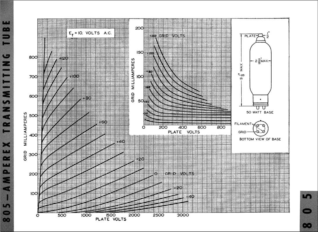
The 805 vacuum tube graph
is from http://grantfidelity.com/site/files/805T-spec.jpg
|
Last operational Range Instrument Approach
from David Hykle April 21, 2011
|
Hi Ed:
Just finished reading the neat article by Tom Johnson regarding Radio Range facilities. Great article ! Some trivia for you.... the last operational Range Instrument Approach procedure was located at Castlegar, British Columbia. I still have the original chart dated 1980 !
Dave
|
1971 FAA Beacon drawing - Sept 3, 2011
Beacon Image and bulb changer - Sept 3, 2011
|
On Fri, Sep 2, 2011, Thomas Johnson < tomjohn316@gmail.com > wrote:
While I was in Washington I made contact with an airway light beacon
chaser that I met through the Montana State Aeronautics people (the
only operators of airway beacons today). He took me to the Toledo,
Washington airport. The airport beacon there (it was in the numbered
airway beacon system) has been replaced by a more-modern unit and the
original beacon and its motor mounted on a concrete pad on the ground.
Kind of odd; why not store it away somewhere? The beacon was an
old 36-inch model, probably from the late 20's or early 30's.
The interesting part was that the back side was open and it was
possible to see and move the automatic bulb-changer. When a bulb
failed, an alternate bulb would be moved into position and illuminated
automatically. I can imagine how such a device might work but don't
know for sure. I've attached two photos. The bulbs had two prongs
that were inserted in the holes in the square receptacles. The bulb
changed when the assembly pivoted about 20 degrees. Any ideas on how
it would have functioned?
Tom J.
LaFarr Stuart commented:
Interesting question about how the bulb changer worked. It had to
detect the burned out filament, then switch the 2nd bulb into
position.
The old GE (Telechron) electric clocks had an indicator that would
turn red if the AC power failed. It was simply a small iron that was
held magnetically when the power was on, when the power failed the
iron was no longer held close to the clock's core magnet and it
pivoted away from the core, and stayed there when the power was
restored.
I would guess the power to the bulb went via an Iron cored choke, and
when the bulb burned out the current would stop letting the mechanism
swing the 2nd bulb into the focal point of the mirror.
|
More interesting pages in the FAA document
sent by Thomas Johnson - Sept 3, 2011
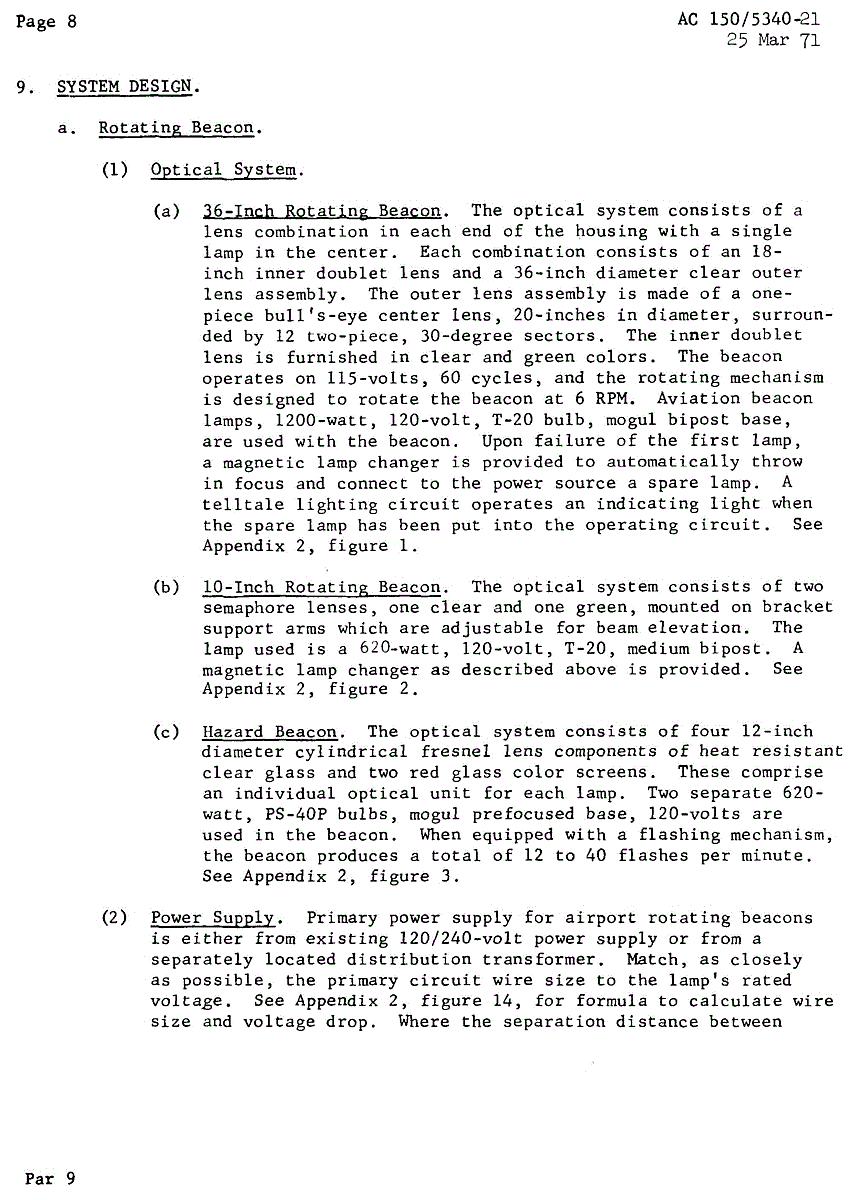
Page 8
|
The most interesting section is on page 8 where it speaks of the
optical system of the 36-inch beacon and says "Upon failure of the
first lamp, a magnetic lamp changer is provided to automatically throw
in focus and connect to the power source a spare lamp. A telltale
power circuit operates an indicating light when the spare lamp has
been put into the operating circuit." The telltale light is then
similar in function to the red indicator you mentioned in the electric
clocks.
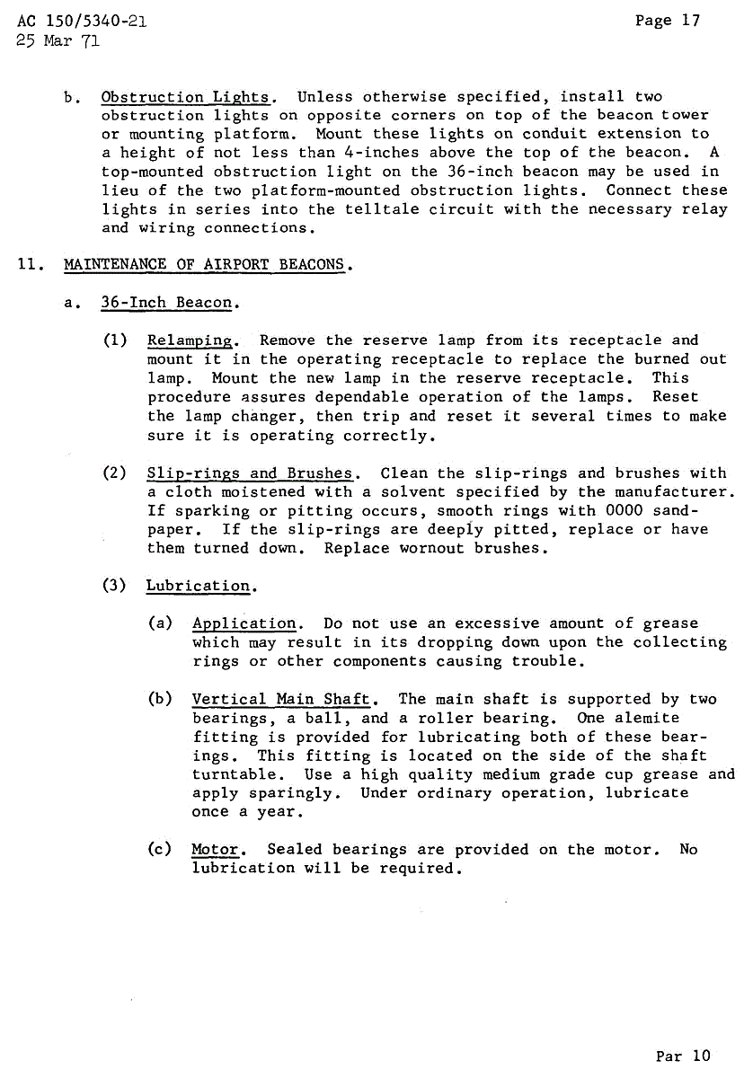
Page 17
|
The paragraph on page 17 about relamping the 36 inch beacon was also
interesting in that it speaks of the reserve lamp and the operating
and reserve receptacles. Also of resetting the lamp changer and then
tripping and resetting it "several times" as a test.
| four pages
|
The Figure 1 in Appendix 2 shows some wiring at a "terminal block in
beacon base" and indicates that the "obstruction lights" are the
telltale. But it doesn't completely explain (at least to me) how the
lamp changer and telltale work together.
| | |
1928 airway beacon towers advertising brochure from IDECO
from Thomas Johnson to LaFarr Sept 6
Aircraft Owners and Pilots Association's AOPA Pilot magazine story about airway beacons - Dec 29, 2011
from Thomas Johnson
|
Airway Beacon Friends,
Would you believe that the January, 2012 issue of the Aircraft Owners and Pilots Association's AOPA Pilot magazine has a story about flying by the airway beacons? Yep, it does!
If you don't receive the paper copy, the direct link to the article is:
http://www.aopa.org/members/files/pilot/2012/january/proficient.html
If that doesn't work for you, try going to the AOPA home page at:
http://www.aopa.org/
Then scroll down to the image of the January, 2012 magazine cover (with a Pitts Special biplane) and click on it.
Next, near the bottom of the page on the left, click on "Proficient Pilot."
The title of the article, "WUVHRKDBGM" mystified me at first although I should have recognized it as the nemonic for "When Undertaking Very Hard Routes Keep Directions By Good Methods" used to remember the sequence of letter codes flashed by the airway beacons.
It's good to see our airway beacons getting good press in 2012. It would have been good if the article had mentioned that airway beacons are still at work in Montana and that beacons and their associated structures have been restored in the Grants, NM area and at two museums in Oregon.
I hope you enjoy the article!
Tom Johnson
|
Radio Frequency Comments and Updates
from Waldo Magnuson - Feb 18, 2012
|
In Tom Johnson's article "Low Frequency Radio Ranges" he mentions that at Miles City, MT the same frequency is used in the Radio Becon (NDB) as was used in the LFR in 1940.
At Spokane, WA the LFR at Felts Field was 365 kc in at least 1936 (i.e. 1936 Sectional Chart). This Radio Range was moved five miles to Marshal, WA to serve Geiger Field, Spokane, WA in the early 1950s. The LFR at Marshal was decommissioned and replaced by a NDB (same frequency 365 kc). The Marshal NDB was later moved back to on-field at Felts Field (maybe late 1980s) still retaining 365 kc.
In 2008 the Felts Field NDB was decommissioned and moved to the Deer Park, WA airport (DEW) about 15 miles north of Felts Field and retained the same frequency.
So the frequency 365 kc has stayed operational in the Spokane area since at least 1936 and is currently operationat at Deer Park in 2012. The dates above were verified using Army, CAA and FAA Sectional Charts.
Skip Magnuson
|
An exchange between Armond Simmons and Tom Johnson
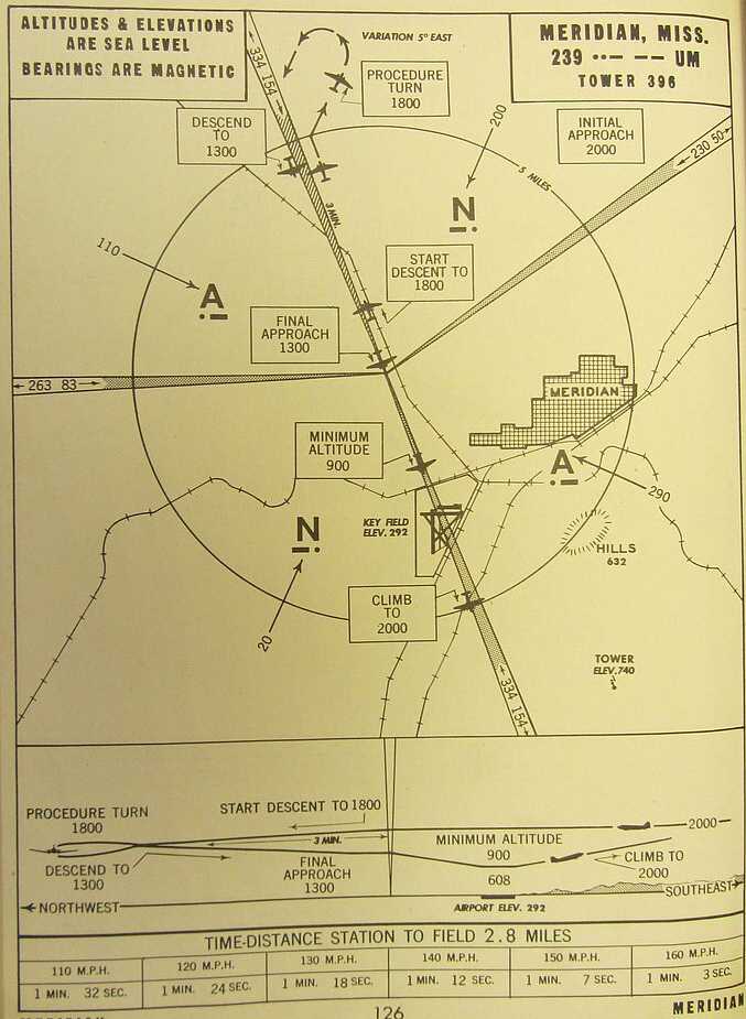
Low-Frequency Radio Range, Key Field, Meridian, MS
        -------- Original Message --------
        Subject: Low-Frequency Radio Range, Key Field, Meridian, MS
        From: ARMOND SIMMONS < psysim111@gmail.com >
        Date: Mon, May 21, 2012

        Interesting webpage  --

        I last used Low-Frequency Radio Range at Key Field, Meridian, MS
        in 1962 or 1963
        --  Do you know the date or year that it was suspended?

        Thanks,

        Armond “Si” Simmons
        104 Wadsworth Lane
        Pell City, AL 35128
        205 338 7378
Hi Si,
Good to hear from you ... .
I do not have a date except to say that the last Low-frequency Range (LFR) instrument approach procedure in the U.S., at Elkins, West Virginia, was deleted on January 16, 1969. On August 25, 1960 there were 258 LFR's in the 50 states, down from a maximum of 440+ in the late 1940's. As you know, the Meridian LFR was operating in 1962/1963.
There was a survey mark (National Geodetic Survey CO1274) at the Meridian LFR center antenna tower. The 1964 Station Description is "RECOVERY NOTE BY COAST AND GEODETIC SURVEY (JMC) - RECOVERED IN GOOD CONDITION. PREVIOUS DESCRIPTION ADEQUATE. TOWERS TO BE DESTROYED IN NEAR FUTURE.” From that information I would say you used the Meridian LFR in its last few years. The 1990 Station Description is "RECOVERY NOTE BY MISSISSIPPI STATE HIGHWAY DEPARTMENT - THE MAST WAS SEARCHED FOR BUT WAS NOT FOUND." And I can see why it was not found. The current Google aerial view shows the site (N32° 22.806', W088° 46.027') entirely covered by woods/brush. I imagine there are still some "remains" of the LFR in the trees there.
I've attached a copy of the May, 1944 instrument approach at Key Field and a copy of the May, 1945 Birmingham Sectional Chart showing the Meridian area. You may find some interesting detail by zooming in.
Tom Johnson - Tuesday 22 May 12
|
Accident
Gary Helming
and Tom Johnson, April 16, 201
-------- Original Message --------
Subject: Very interesting article
From: helming@juno.com
Date: Mon, April 15, 2013 8:45 pm
I wrote Mr Johnson about the use of LFR in this area and a person that I
knew who operated the Whitehall Montana, one.
I have one of the Montana Aeronautical beacons that shines into my
bedroom window every night--all night.
AS you probalby know, the beacons have two red lights on them with
directional Fresnel Lenses and then the white
rotating light you spoke of.
I work for the local electric company and
have had to climb the tower of a beacon before, to read the
electric meter. The newer ones have an arc type light at the top that
turns on and off, rather than rotates. The older ones have the rotating
light and a cam system that flashed a Morse code symbol on the Red
Fresnel lights when the white light were turned away from the viewer. I
know
that you can only see the two red Fresnel lights when you are on course.
It is my understanding that you fly perpendicular to the direction to the
beacon until you see a red light and then fly toward it. When you go
over the beacon you can then look for the red light from the next beacon
and so forth. The one out my window flashes "K" _._
Cheers
Gary Helming
Butte, MT.
-------------------
--------
Original Message --------
Subject: RE: Very interesting article
From: Gary Helming
Date: Tue, April 16, 2013 4:48 am
I know that the operator of the old Whitehall LFR lives in Idaho. I talked with him on the phone once when he and his wife were up visiting my parents.
In 1950 Montana's worst commercial air crash happened in the mountains just out my window. In following litigation there was an attempt by the airline to blame the LFR system for the plane being severely off course. That never went anywhere but was very interesting to me. The air crash is of local interest as hikers continue to visit the crash site which still has the plane wreckage in place.
I love the beacon. I'm glad Montana keeps them although my boss is a private pilot and says "......if you're flying by the beacons you're really in trouble."
Chewers
Gary Helming PE
H-Comm Communications LLC
Butte MT.
--------------------------
On Tue, Apr 16, 2013 at 11:45 AM, Thomas Johnson < tomjohn316@gmail.com > wrote:
Hi Gary and Ed,
I'm pleased to hear that you enjoyed the article about four-course, low-frequency radio ranges
(LFR) that Ed has put up and maintained on his website. I had a good visit exploring the
Whitehall site in 2008 thanks to holes in the fence.
Just in the last few years the LFR's brick building at Belgrade/Bozeman has been torn down. The same thing has happened at Burley, Idaho.
An airline accident where the LFR was implicated was United Flight 16 at Centerville,
Utah on November 4, 1940. A concern there was snow bridging insulators in the antenna
system. The accident report has a long discussion of LFR operation, monitoring and problems.
Later in the morning after the accident a test flight found abnormal signals such as receiving an "A" when making a complete circle around
the LFR (see pages 54-56 of the accident report that is available here):
Accident report link
- click on "Accident Reports" (above left-hand photo),
- then "Browse Aviation Accident Reports by Location" (second item),
- then "United States",
- then "Utah" or "Montana" or wherever.
If the reports are small and hard to read, the pdf should allow you to enlarge by clicking on the + magnifying glass.
|
Go to report number 2 (November 7, 1950) for the accident you referred to in your email. I haven't seen that report before but it looks like it is interesting.
Good to hear from you, Gary. And thanks for your help and forwarding, Ed. More later.
Tom J.
|
Never Knew This About A-N Ranges Before!
- Tom Johnson, Feb 26, 2015
|
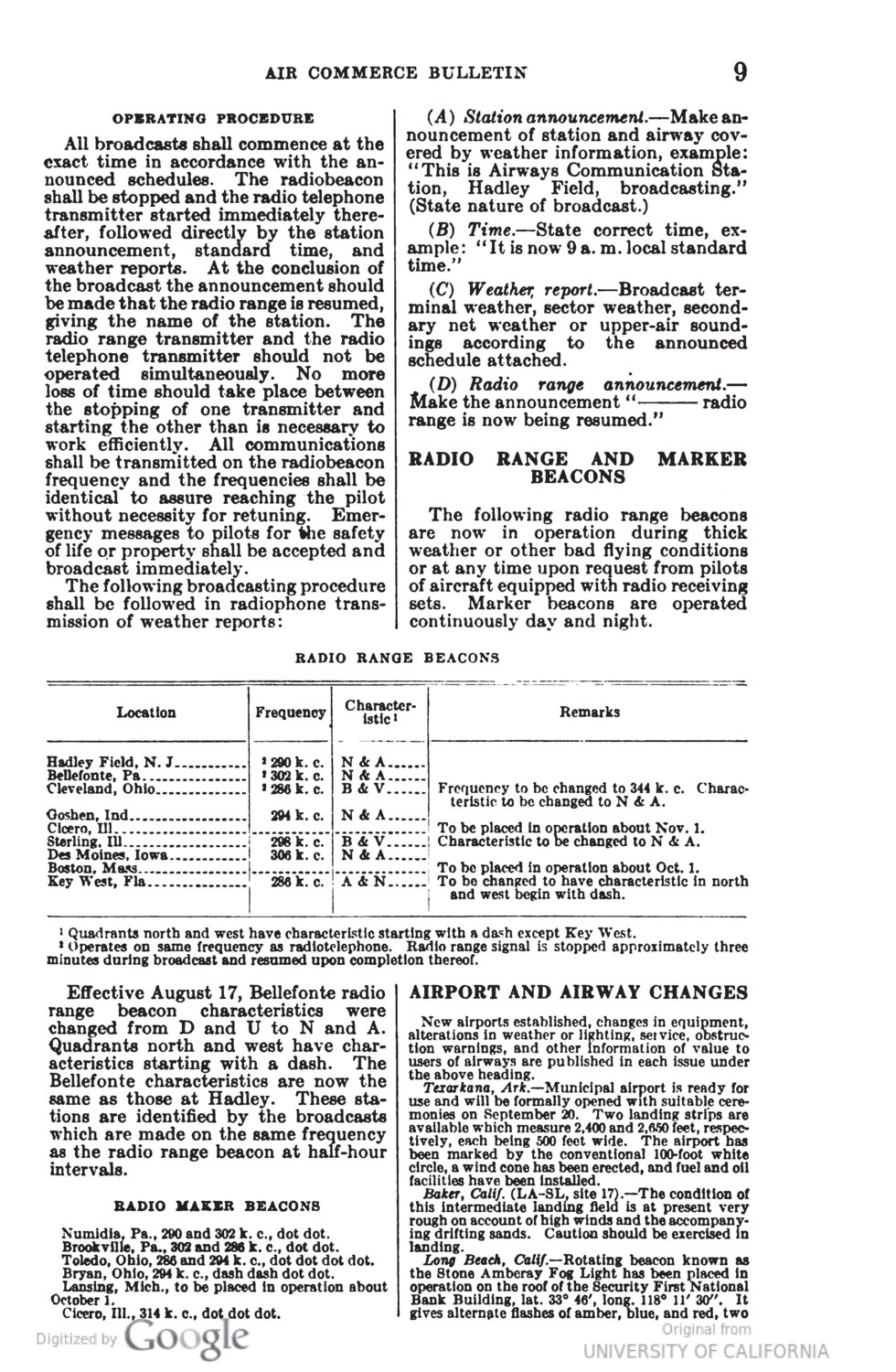
Hi Aviation Archeologists,
Until I recently read the attached page from the September 15, 1929 Department of Commerce, Air Commerce Bulletin (Vol. 1, No. 6, Page 9) I never knew that the four-course, low-frequency aviation radio ranges were anything but A and N ranges.
Back in September, 1929 there were only 7 ranges operating with two more coming before the end of the year. The text tells us that the Bellefonte, Pennsylvania range had changed the previous month from D (dash & 2 dots) and U (2 dots & dash) to N & A. And the table tells us that the ranges at Cleveland, Ohio and Sterling, Illinois were to be changed from B (dash & 3 dots) and V (3 dots and dash) to N & A.
Amazing. It would have been interesting from our perspective to hear the debate over whether to use D & U or B & V or N & A.
Tom J.
|
Plymouth, UT range -> Malad City
- Tom Johnson, Nov 18,2020
IMG_0081.jpg
IMG_0337.jpg
IMG_0028_1.jpg
|
The Plymouth, UT range was shutdown and moved to Malad City, ID in 1944/45. The same 314 frequency made the move. Plymouth last appeared on the January, 1944 Pocatello and Salt Lake City Sectional Charts. No ranges in this area appear on the July, 1944 Pocatello and September, 1944 SLC Sectionals. The Malad City range first appeared on the February 1945 Pocatello Sectional.
The Malad City range center tower was at 42 12' 45.6" -112 20' 21.0" The transmitter/generator building was immediately to the NW. All five antenna tower bases plus the building slab were still extant less than 12 years ago. Attached photo 0081 is of the North antenna tower base with LaFarr Stuart and photo 0337 is of me on the building slab with the center tower base beyond in the rear.
Another range: June 1936 and April 1937 Sectionals show a LFR close to the NE side of the city of Idaho Falls, ID. 1935 data shows a Loop-type range at Idaho Falls. April 1939 and June 1941 Sectionals show a LFR in a new location 4+ miles north of the city. 1939 data shows an Adcock-type range (5 towers). Then 1944 data shows a non-directional low-frequency beacon. Then the May 1946 Pocatello Sectional shows the 4-leg range north of the city again (1939 and 1946 location at 43 33' 17,4" -112 01' 56.4"). I've attached photo 0028_1 showing the Idaho Falls transmitter building from the street. That's a FAA security agent in the white and black uniform out front! I didn't see any evidence of antenna tower bases.
Idaho Falls is another case of moving LFR's! Toledo, OH and Tucson, AZ had 3 locations each.
|
Enjoyed your LF Range Article/ New Website - Joe Consumer, Dec 15, 2020
From: Joe Consumer
Sent: Tuesday, December 15, 2020 10:59 AM
To: 'Thomas Johnson'
Cc: 'ed@ed-thelen.org'
Subject: RE: Enjoyed your LF Range Article/ New Website www.flyingthebeams.com
Dear Tom,
Just wanted to give you a further update. Over this rainy shelter-in-place weekend I went through and cross checked your database against the information I had. It was a lot to cross correlate the 601 stations I had with the 581 station in your database, and again with the 440+ stations in the 1944 Army Air Forces Radio Facility Chart (AAFRFC) but here’s what it produced.:
- This process found another 48 stations I missed, mostly ones that existed in the early and late years of the systems and were not in the 1944 AAFRFC – these have now been geocoded and added to the map. There are now 658 total stations in the map database.
- I’ve added “Approximate Years in Service” for each station – e.g. a bracketed value, e.g. <1944-60> based on the information from your database. I also added a summary graph that shows the number of active stations per year partly driven by your summary table. I think it adds depth to show when a station was active, so thank you for compiling all of this info – I credited you again on the Maps page.
- I added the type of station based on info in your database, the 1944 AAFRFC, and other sources – e.g. LFR (RA), LFR (MRL), NDB etc.
- While I was at it, I added the station Morse Identifier that was shown in the 1944 AAFRFC or on a sectional at time a station was active. Yes, I know that these changed over time but many were constant over several years so I thought it would still be useful. I advised folks that if the wanted to do a detailed examination to verify years in operation, frequencies, etc. its best to look at sectionals.
- I added an Errata and Miscellaneous Section under Maps that provide two lists:
- 12 airport locations that had a “Low Power Range” in the 30’s. As there is a dearth of aerials and topo maps that show these, there’s no info that can geolocate these on the map so I felt it was better to list them.
- 8 Stations that were listed a “Proposed” or “Under Construction” but it appears never became operational. Again, nothing to map so a list was better.
Your information was very thorough and very complete
– I only came across 8 stations that I wasn’t able to locate on the Library of Congress Sectional and 16 stations that appear to be duplicates due to name changes as follows. That’s only 2.8% which is pretty damn good! Let me know if you think I missed something.
Unable to Locate the Following Stations (8 - 1.4%)
| Ainsworth
| NE
| Was Unable to Locate on Library of Congress Sectionals
|
| Brinkley
| AR
| Was Unable to Locate on Library of Congress Sectionals
|
| Endicott
| NY
| On Lists - but was Unable to Locate on LOC Sectionals (Perhaps as it was a Localizer)
|
| Fort Madison
| IA
| List Only? Was Unable to Locate on Library of Congress Sectionals
|
| Martha's Vineyard
| MA
| Was Unable to Locate on Library of Congress Sectionals
|
| Montgomery Muni Airport
| AL
| Was Unable to Locate on Library of Congress Sectionals (Maxwell AFB Closest)
|
| Moran
| KA
| List Only? Was Unable to Locate on Library of Congress Sectionals
|
| Ozark
| AL
| Was Unable to Locate on Library of Congress Sectionals
|
Duplicate / Name Change Stations (16 - 2.8%)
| Bellefonte - Visual
| PA
| Same as Bellefonte
|
| Bristol
| TN
| Same as Tri - City, (Tri - City Description Updated)
|
| Cicero
| IL
| Same as Chicago (Noted on Chicago)
|
| Columbus
| GA
| Same as Lawson (Lawson Description Updated)
|
| Detroit
| MI
| Same as Detroit (Romulus Description Updated)
|
| Elizabeth
| NJ
| No Such Station Found - maybe this was Newark (closest station not clearly labeled in 30's)
|
| Ethel
| WA
| Same as Toledo (Toledo Description Updated)
|
| Floyd Bennett (New York)
| NY
| Same as Floyd Bennett (Floyd Bennett Description Updated with "Brooklyn")
|
| Foster Field
| TX
| Same as Victoria (Victoria Description Updated)
|
| Knight
| WY
| Was not able to locate a "Knight" or a "Knight Field" Wyoming
|
| Modesto
| CA
| VOR on 1955/56 section but no range stations (Perhaps this was Castle?)
|
| San Antonio, Kelly
| TX
| Same as "San Antonio" (San Antonio Description Updated)
|
| Saugus
| CA
| This Appears to be Newhall Station
|
| Thermal
| CA
| Same as Indio (Indio Description Updated)
|
| Truth or Consequences
| NM
| Same as Engle / Hot Springs (Description Updated)
|
| Zuni (was El Morro)
| NM
| Same as El Morro (El Morro Description Updated)
|
Again, your hard work was absolutely helpful and invaluable – so thanks for doing this, and I’ve expressed that thanks on the site!
Hopefully our combined information will ensure that we can better keep the history and lore of this system alive for future generations.
By all means, please go through my material and info and let me know if you have any comments, additions or corrections. Again, thank you for all your help! Look forward to continued collaboration.
Best Regards,
DD
Doug Davis
|
If you have comments or suggestions, Send e-mail
to Tom Johnson - tomjohn316 @ gmail . com
Back to Home Page


