Return to Home Page,
Return to Nike Location index
go to previous,
go to top,
go to next
| . | For locations and views, fly in using Google Earth thanks to NikeSiteSearchers |
OA-17 Kauka/ Kahuku
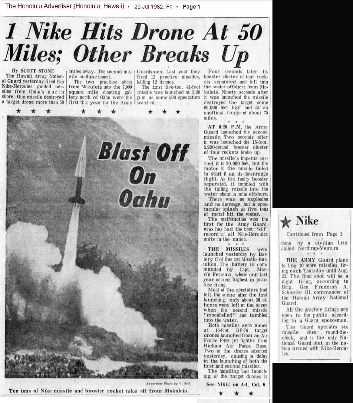
OA-32 BellowsAFS/ Waimanalo OA-63 Ewa/ Makakilo OA-84 Waialua /Dillingham ------------------------------------- Nike Target Practice in Mokuleia, Hawaii (newspaper from Thomas Page, June 2019) ------------------------------------- "Hawaii Army National Guard Guided Missile Program" - (great map) - by John Bennett - 1.3 MB "Hawaii Army National Guard Guided Missile Program-draft" - (more meat) -by John Bennett - 7.8 MB OA-84 "Defense Environmental Restoration Program For Formerly-Used Sites - Inventory Project Report - NIKE SITE No. 1 - (Dillingham Military Reservation) Mokuleia, Waialua, Oahu - Project No. H09HI039110" February 1990 - from {Tamburello, J} Mar 2014 - 17 MByte Q & A - Oct 2017 |
| Designation | General Location | Detailed Location (Current Status) |
| OA-17 | Kauka/ Kahuku | C - 2.6 WNW Kahuku, Kawela Camp Rd (US Army; range control facility)
[NikeSiteSearchers Probable (?): GoogleMap (appears to be no longer extant) ]
L - 2.5 NNW Kahuku (US ARMY; Kahuku Army Training Area)
|
| OA-32 (double) | BellowsAFS/ Waimanalo |
[{Page, T} A Bellows Field web site with a Nike
site oriented
picture ]
C - [{Turner, D}Kamehame] Ridge (US ARMY; abandoned) Hike ]
L - SE corner Bellows AFS ((P) Bellows AFS; PACAF communications facility,
DOD recreation facility)
|
| OA-63 (double) | Ewa/ Makakilo | C - 2.3 NNW Ewa, Palehua Rd (US Army; abandoned)
[{Page, T}, GoogleMap IFC Site, OA-63C-1: , GoogleMap IFC Site, OA-63C-2: ]
L - 2.3 NW Ewa (US Army; abandoned)
[{Murdock, S} (Nov '99) Control Site 5: 21-23-11N, 158-06-17W. Buildings shown are a Sentry Box, EM Barracks & Messhall, Administration Building, Flag Pole, Generator Building, HIPAR Building and Antenna, TTR Tower, MTR Tower, ACR Tower, TRR Tower, and Inter-Connecting Corridor. Control Site 6: 21-22-39N, 158-06-42W, 4.23 acres. Buildings shown are an 18 Man Barracks & Messhall, Administration Building, Sentry Box, Flag Pole, Engine Generator & Frequency Charger Bldg, Inter-Connecting Corridor, and Concrete Pads for TTR, MTR, ACR, and RCT. A separate small parcel (.86 acre) north of this site has a concrete base for Bore Sight Mast. Administrative Area Launcher Sites 5 & 6: 21-22-06N, 158-06-31W. Buildings shown are two Administration Buildings, two 22 Men Bks & Messhall buildings (similar to OA-32L mentioned above), Sentry Shed, and Flagpole. Launcher Site 5 & 6: 21-21-50N, 158-06-44W. Buildings include two Sentry Sheds, two Towers [security watch towers], Missile Assembly and Test Bldg, Warhead Bldg, Generator Bldg, and the same launcher layout as OA-32L. |
| OA-84 | Waialua /Dillingham | C - 5 SW Waialua, Peacock Flat Access Road (USAF training site)
[{Tamburello, J} Mar 2014 - Coordinates are 21�32'45.60"N, 158�11'42.54"W ]
L - 3 WSW Waialua, Dillingham Field ( Dillingham Airport; site abandoned)
A -
|
Q & A - Oct 2017
Were the Nikes in Hawaii always the Hercules variant or were there other variants before Hercules?
As Ed indicated, the Nike Ajax preceded Hercules, going into operational service at a tactical site at Fort Meade, MD, in December 1953. The Oahu sites were part of the second round of deployment (which included the addition of several defenses around SAC bases in ConUS) and were Hercules-only.
Were the Nikes in Hawaii ever tipped with nukes or were they all HE frag? (Or was there a mix?) (or were they HE-tipped, with warheads somewhere on Oahu for the eventuality?
The Army never discussed or released information on the mix of HE and nuke warheads in the defense areas, but you can assume the four Oahu sites were nuke-capable.
Were there ever any spares/reloads kept around, either on-site or at an ammo dump (magazine) elsewhere on Oahu?
Each battery had additional missiles ready for reloading and firing. As of yet I haven't run across documentation where/how the missiles on Oahu were stored. Additional missiles may have been stored elsewhere on the island.
If there were Nike ordnance kept elsewhere, was it the Lualualei Naval Magazine, the Iroquois Point naval magazine, or the Waikakalaua Ammo Tunnels vicinity Kunia road? (Or, the Waikele magazine; I know for a fact there was nukes - but don't know what kind and for which service - stored for much of the cold war at Waikele, but not sure if other sites at Oahu had nukes).
Similar answer; as of yet I haven't seen any documentation indicating where the warheads were stored and maintained. The logical site would've been a nuclear-certified facility, such as one of the naval magazines.
Hope this information helps.
Mark Morgan
Gordon Lunn to James Cox
Gordon
Return to Home Page,
Return to Nike Location index
If you have comments or suggestions, Send e-mail
to Ed Thelen
Updated June, 2019
Mark Morgan
Mr Cox - Ed copied me on your email and his response:
Rings of Supersonic Steel
Ed, some partial answers...
We should ask Howard Crist, who served there before coming to California, but he died a couple of months ago. Let me see if I can find out
go to previous,
go to top,
go to next