Return to Home Page,
Return to Nike Location index
go to previous,
go to next
Locations of Former NIKE MISSILE SITES (text)
| LI-01 | Ceresco/Davey
15 m. N Lincoln
| occupied from 1960 to 1966
C - (High School)
[{Pytko, Walter} (September 2005) The IFC site is
pretty much intact and is Raymond Central High School.
[{Branting, Rob} (Feb 2003) Raymond Central High
School some buildings intact but site greatly modified for school. ]
[{Murdock, S} GPS=41-01-25 96-44-50 ]
L - (abandoned)
[{Branting, Rob} (Feb 2003) looks the same as
Crete launcher, storage on site but abandoned. ]
[{Murdock, S} GPS=41-02-10 96-44-25 ]
|
| LI-50 | Crete
20 m. SW Lincoln
| occupied from 1960 to 1966
C - (low income housing)
[{Branting, Rob} (Feb 2003) still largely intact,
the COs building/administration is apartments and barracks across are abandoned.
The improved nike radar stand for ABAR is still there. ]
[{Morgan, M} The IFC is about a mile due north of
the launcher area on the north side of NE 33 ]
[{Murdock, S} GPS=40-39-20 96-49-42 ]
L -
[{Branting, Rob} (Feb 2003) guard shack and other
buildings intact. site used for storage and otherwise abandoned. ]
[{Murdock, S} GPS=40-38-45 96-49-25 ]
|
| OF-60 | Cedar Creek
15 m. SSW Omaha
? Louisville Base
| occupied 1960-1966
[{Gallery, Jerry} Nov 2019 - Anyway; the Nebraska Base, OF-60 was refered to as the
Louisville Base, not Cedar Creek. Cedar Creek was about three and one half miles north of the base.
It is just a group of houses. No services at all, no stores, service stations, etc., not even a post office.
A population of less than 100. Louisville was two and one half miles west of the base, with a population
of over 1200. Everyone including the Army refered to OF-60 AKA "B" Battery 6-43 as the Louisville Base.
The mailing address was B 6 43 Louisville Nebraska. All military orders, passes, etc. were headed;
Btry B, 6th Msl Bn(NH), 43rd Atry, Louisville, Nebr. ]
C - 4SSE Cedar Creek, 10312 Agnew Rd. E of 108th St., (I) Camp of the Risen Son,
religious retreat center
[{Murdock, S} GPS=40-59-20 96-04-28
[{Gallery, Jerry} Nov 2019 - The IFC Area is now a church camp. They were really glad to
see me as I was the only one to visit there who was once stationed there. They had a million questions for me. All the buildings
are still there and in great condition and all are being used. They gave me the grand tour most of the interior is the same as when
it was a military base, even the paint colors, green, blue and yellow. ]
L- 45 Cedar Creek, S side of Agnew Rd, W of 108th St., - private residence and equipment storage
[{Murdock, S} GPS=40-59-01 96-05-30
[{Gallery, Jerry} Nov 2019 - The Launcher Area is owned by the farmer who lives
across the road from the area and also grew up there when the base was operational. He is very friendly and more than
willing to allow me access to the entire site. He also had quite a few questions for me. All the buildings are in remarkably
good condition. The berms and fences are still in place. ]
|
| Omaha AFS | 15 miles NW Omaha,
72d St & NE 36th
| Latitude: 41-21-40 N, Longitude: 96-01-25 W - as per http://www.radomes.org
Seems to be near McKinley St. and N 72nd St. as per Google Earth
Nike Birdie installation 1960-1966
SAGE site 1955-1968
[{Page, T} (Aug 2007) F.Y.I., at
http://local.live.com/ , Microsoft Virtual
Earth? "Bird's Eye" aerial imagery has been added for the greater Omaha, NE, area.
Included are Offutt AFB, NE (HQ SAC, now STRATCOM); the former Omaha AFS, NE (Z-71),
radar site & Nike AADCP; and the Council Bluff Nike missile site (OF-10) across the river in Iowa.
The town of Cedar Creek, NE, has this imagery, but not its old Nike missile site, located just south
of where the imagery cuts off. ]
|
go to top
| NY-54 | Holmdel /Hazlet
| occupied 1957-1968
[Don Bender's previous web page],
[{Bender, D} "The IFC area is now Phillips Park
(off of Telegraph Hill Road in Holmdel), a
component of the Monmouth County Park System.
" ...this was a rare
"hardened" Nike site with heavily-constructed, blast-resistant structures
at both the IFC and Launcher areas. The battery and radar control vans
were located side-by-side within the reinforced structure which was
protected by 8-ton doors and a special, pressurized air filtration
system. Crew accomodations were provided within this building, as well as
in a smaller structure at the launcher area. "]
C - off Telegraph Hill Rd - (O) Phillips Park, communications facility. Admin area intact
L - N of NJ 34 off Homdel Rd - (O) Homdel County Park
[{Piland, D} (July 2010) The Google Earth location
for the Homdel / Hazlet, NJ - NY-54 - Launch Area is not correct.
From HistoricAerials.com the actual launch site is at Lat: 40.3779 Lon: -74.1876.
Also, RSS-3 indicates that there were 1A/2B magazines. This is also
incorrect, since there are only two magazines there. RSS-3 also lists only
30A and 12L-A and doesn't mention Hercules missiles, although it shows a
HIPAR and conversion date. ]
[{Bender, D} The Launcher Area is currently
located nearby within Holmdel Park, also a Monmouth County Park. The only
remnants of the site are portions of the exterior perimeter fences at
both locations. However, the family housing area adjacent to the IFC
area is mostly intact. Directly adjacent to the former IFC area is an
impressive "Telstar" facility with four huge, white, dish-type antennas
arrayed in four directions."
|
| NY-55DC | Highlands AFS/AADB
| 1 mile South of Highlands, Portland Rd, 1 S Navesink Twin Lights
Current condition - Obliterated - Rocky Point Section, Hartshorne Woods County Park
[Don Bender's previous web page],
More details at Radomes.org
One radar tower -- the AN/FPS-26 height-finder -- is still visible. Everthing
is gone now; the entire site was bull-dozed a few years ago.
We have photos (old and new) on our web site, http://www.radomes.org/museum/
Highlands AFS was the parent station of Texas Tower #4 (TT-4),
one of three off-shore AC&W radar platforms that existed in the mid/late 1950's
and early 1960's. TT-4 collapsed in 1961 during a violent storm, killing all
aboard. The Texas Towers reportedly [was] mentioned on an episode of The
History Channel's "Modern Marvels -- Engineering Disasters III" ]
|
NY-56
Double site (Herc) | Ft. Hancock - Sandy Hook
|
occupied 1954-1971
from. Paul Klco < gidad1 at aol dot com > May 21, 2023
|
I am a tour guide at NY-56, was a duel Site. - This site is the LAST Nike site in CONUS in its ORIGINAL configuration. LCA and IFC area. IFC Area has a LoPar RADAR, a TTR, TRR, MTR, RC Van ANOLOG and BC Van DIGITAL. Tours starts in the IFC Generator Building. The LCA, 1 mile away, has an Assy Bldg, War Head Bldg, Dog Kennels and 4 Magazines under water. Goggle NY56Nike.weebly.com. The site is under GATEWAY NATIONAL PARK SERVICE. The site is not as functional or pretty as SF-88, but SF-88 IFC Area is in the LCA. Bill Jackson is the team leader and a tour guide. Bill was a LCA Section Chief at NY-56. We are restoring the RC, BC Van and two Ajax Missiles the best we can.
Paul Klco
|
The site historian (2019) is:
- Tom Hoffman, Park Ranger Historian < tom_hoffman @ nps . gov >
- Gateway Sandy Hook National Recreation Area
- 26 Hudson Road, Highlands, NJ 07732
Ft. Hancock Nike Association the volunteers
who restore the Nike artifacts ( missiles, vans, ... ) and give the tours :-))
pictures of current condition, date unknown
National Park Service web site
w open hours - thanks Gordon Lunn
and oral histories
Paul W. Klco says "We're trying to locate Ajax or Herc Manuals for NY-56.
NY-56 is the only site on the East Coast that has IFC Area with Radars
(MTR - TTR - TRR - LoPar) with Vans( RC and BC). We are a volunteer association.
We are living artifacts of the Cold War days with the Herc Missile System.
Bill Jackson is President."
a news paper article,
spotted by Peter DeMarco,
his web site
a web page
[Don Bender's previous web page]
Nike A Remarkable YouTube Presentation,
10 minutes - recommended by Jon Little
[{Siegfied, W} (August 2012)
This is a site everyone interested in cold war history
should visit. The people that volunteer here as well as the Rangers are
interested, helpful and friendly. Both the IFC and launch areas are
intact and in the process of restoration. Tours are occasionally
available and publicized on the volunteer website and through the park
service. If you are only visiting the Nike areas and Ft. Hancock there
is no fee to enter or park. Beach parking for the "clothing optional"
beaches and concession areas is $15. ]
[{Tannucilli, A} - July 2007 - "... good state of preservation.
I've been on both tours (IFC and Launcher Areas). ]
Latest from Mary Rasa April 16, 2007
dated before Hurricane Sandy hit (October 29, 2012)
This Hercules and 2 Ajax missiles were transferred to the park about 3 years ago from the Air Force.
The Sandy Hook foundation paid for the Ajax's shipping 2 years ago and the Herc just arrived.
As you can see this massive missile is going to make an excellent display.
The park was just awarded funding to work on the launch site. The main objective is to allow visitor
access into the elevators, and since they do not have stairs, the park will be constructing a tunnel
from the buildings on site into the pit. Enjoy the photos.
Mary Rasa, Museum Curator, Gateway NRA/Sandy Hook, P.O. Box 530, Fort Hancock, NJ 07732- (732) 872-5953
| 
|
|
Turning junk into beauty - Ajax Restoration Project
|
[{O'Callaghan, B}
The site in Sandy Hook NJ remains one of the best preserved (as of
1990) with open and dry magazines and easy access. The IFC site there is also
well preserved but used as a state dept of transportation storage
facility-signs poles etc.]
[{Make, B}The site was an Ajax site converted to Hercules, this was verified
by a Fort Hancock's historian, who also pointed out that in c1959 both were types in
place there. All the rails
and launchers are now gone. The ground level is being used to store building materials.
One of the magazine's elevator doors were left open. In it, there was just enough of
water to obscure the presence of a pit below the elevators resting place. The elevator
machinery is still there, as is the air scrubbers. Except for a few rusted stairs and the
missing equipment, I think the magazines looked in remarkable condition, for their age.
One of the other magazine may still be dry. The site is obscure and not open to the
general public because of safety concerns. Yet I think this site (within the SALT Treaty),
the radar site and Fort Hancock in general could make an interesting grass-roots
restoration project because of their history.]
[{Bender, D} Site NY-56 was a dual Nike site containing, in
effect, two launcher areas and two IFC facilities. The site thus had a
"DCL" Dual Control Launch capability to track and engage two
separate targets, simultaneously. The site contained 4 "B" type magazines
all of which were converted (in two stages) to operate with Nike Hercules
missiles.
Fort Hancock also contained antiaircraft artillery (AAA) gun batteries
operating concurrently (for some years) with the Nike facility. According
to some reports I've received, temporary, revetted Nike installations
were erected on Sandy Hook prior to the completion of the permanent
facilities.
Although the former base is generally intact, having been spared the ravages
of "development", many of the buildings and structures, including the
magazines, are in a rather dilapidated condition. Some of the radar
towers at the IFC area are of an unusual design not found at other New
York Defense Area Nike sites. The Nike facilities were included in the
overall nomination of the Fort Hancock historic area to the National
Register of Historic Places.]
C - 35 Ft. Hancock, Sandy Hook - (I) National Park Service, Gateway National Recrreation Area
Paul W. Klco says
"NY-56 is the only site on the East Coast that has IFC Area with Radars
(MTR - TTR - TRR - LoPar) with Vans( RC and BC).
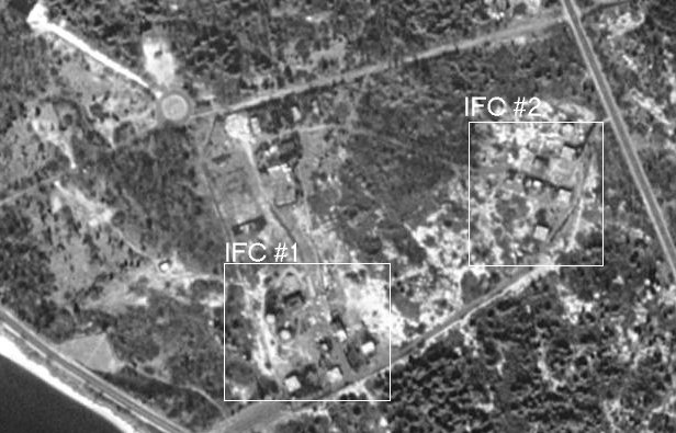
[{Wallace, R} Ed - [the] MsrMaps photo is too
far north. See the attached jpg [65 K bytes].
I was IFC Plt Ldr at IFC#2 in 1963 for
a few months. IFC#1 had a HIPAR on the north side of the IFC#1 area. ]
L - 45 Ft. Hancock, Sandy Hook - (I) National Park Service maintenance yard
Ajax missile restoration blog :-)
|
| NY-58/60
| Old Bridge Township,
4 miles south of
South Amboy
| occupied 1955-1968
[Don Bender's previous web page],
C - Jake Brown Rd., 1 W of US 9 - ((O)) open field
[{Larsen,D} April 2014, The IFC area is an open field
with three concrete foundations (non-tactical structures) and a wellhead are the only Nike remains.
L - NJ 9 & Jake Brown Rd, Old Bridge Township ((renamed from "Madison Township" in 1975) Board of Education)
- Updated June 2020 from Richard Pucciarelli,
Madison-Old Bridge Township Historical Society
[{Larsen,D} April 2014, The Launch area belongs to the
Board of Education and their logistics, maintenance and school bus office and parking is
located there. The missile assembly & test building and warheading building have been
nicely rehabbed for office and break room spaces. The POL storage building, guard shack
(magazines), and an acid storage shed also remain. The generator building is gone and I did
not spot kennels while looking through the fence at the rear of the property. In 1994 the town
closed the pits with help from an environmental company they hired. The area is paved over
with the exception of a small portion of it near the back fence line.
There, one blast deflector can be seen.
Between the bus yard and the Route 9 intersection but on the other side of the street
is a group of Butler Barracks buildings that are maintained and used by the Board of Education.
The boiler house has been renovated and still supplies heat for the surrounding buildings.
There's a concrete block latrine behind the barracks. Farther down the road is a reasonably
intact waste treatment facility that is no longer used.
A -
[{Larsen,D} April 2014, At the Family Housing area all
homes have been razed. I understand a couple of them burned, and SWAT teams practiced
on the others. Finally all were removed. The town is using and maintaining the adjacent
water tank and pump house.
|
| NY-65 | South Plainfield
| occupied 1955-1971
[Don Bender's previous web page],
C - N of I 287, E of Durham ((O) field)
L - Hadley Rd & Durham Rd ((O) Hadley Shopping Center; industrial park) |
| NY-73 | Summit/Watchung
|
[{Bender, D}
a Site History]
[Don Bender's previous web page],
L - (Union County Dept. of Parks and Recreation)
[{Bartolick, J} The launcher site is now the new site of
Watchung Stables, operated by the Union County
Park Commission. The old stable site was destroyed by the construction of
US 78. There is no evidence of the launcher site remaining. The IFC site
was in back of Governor Livingston Regional High School. When I was a
student there (1969-1972) there were still some structures standing, but
everything except some fencing is now gone. Both of these properties were
originally owned by the county and I guess they reverted when the Army
moved out. The launcher site was used as a county civil defense site for a
few years, then left to the usual ravages.]
[{Bender, D} Interestingly, plans were made to create a
"dual" site with 6 magazines
and two IFCs at NY-73. These plans were never realized. The site was only
operational for about 4 years. It's construction was hotly contested by
county residents, which helped to delay its siting and construction. After
its "sister" sites (Livingston/East Hanover and S. Plainfield) were
converted to Hercules operations, it was finally closed in late 1962.
[{Bender, D} (Jan 00)I have written and designed a historical marker
for the former Launcher Area, currently the site of the Watchung Stables. I and a
representative of a local historical society have discussed a similar marker for the
IFC Area with local school officials. ] |
NY-80
(double)
| Livingston
/Essex Fells - East Hanover
|
[Don Bender's previous web page]
article by Don Bender ,
C - Beaufort Ave, off Eisenhower ((I) Riker Hill Park)
[{Bender, D} The IFC area in Livingston is now Riker Hill Art Park.
Most original buildings
and radar towers (and foundations) still exist. The buildings are used
as studios by local artists.
Also see article ]
L - River Road & NJ 10 ((O) industrial park)
[{Bender, D}Launcher Area is in East Hanover, NOT in Essex Fells.
The Launcher Area lies
on the west side of River Road, a short distance from NJ 10 in adjacent East Hanover
Township. Most of that site has been demolished. However, one can still
see one original barracks building, a paint shed, and a raised mound for
one of the site's two Launch Control Trailers. The family housing area is
directly adjacent to the site and mostly intact, although vandalized. There is
also a playground in this area.]
[{Bender, D} (Jan 00) The remaining portions ... including the Housing Area,
a barrack, a basketball court and a raised mound for one of two Launch Control Trailers
is destined to be demolished and turned into a residential development.
Photos at Don Bender's WWW site. |
| NY-88 | Mt. View /Wayne/
Packanack Lakes
| [Don Bender's previous web page],
C - Ratzer Road & Alps Rd ((I) abandoned)
[{Bender, D} (Jan 00)
The IFC area off of Alps and Ratzer Roads is partly also intact. Some
buildings were briefly used by Fairleigh Dickinson University as part of a
"satellite" campus. Most of the remaining buildings and structures have been
heavily vandalized. The remains of two tracking radar towers can still be
seen (concrete columns, topped by platforms, although without their
external, steel skeletons) near the top of the site.
The IFC Area is scheduled for demolition. The hilltop location will be transformed into a
luxury housing development. ]
L - NJ 23, N of I 80 ((P) Circle Lumber Company)
[{Bender, D} The Launcher Area on Route 23 North is partly intact.
A barracks building has been adapted to serve as county and township offices, and the
missile assembly and test building is used for maintenance purposes. School buses
are parked atop the missile magazines. The special missile walkway leading
from this building to the revetted acid fueling area is extant as are some
remnants of the acid fueling area, although the earthen berms have been
removed.
|
NY-93/94
(double) | Ramsey/
Darlington /Mahwah / Franklin Lakes
| [Don Bender's previous web page],
Annotated aerial views from George C. Freidel via Richard M. Levine.
Overview,
Launcher Area,
Hercules IFC,
Ajax IFC,
each image 120 K Bytes
Sept 9, 2015, a flurry of comments: (most recent on top)
- from (Piland, D)
I would suggest that the south IFC be labeled �Ajax/Hercules IFC Area.�
It also appears from Historic Aerials that the North IFC Area was the
Headquarters (Admin Area) from start to finish.
- from {Page, T}
I just noticed your graphics ...
You labeled one Integrated Fire Control site as "Ajax IFC Area" and the other
as "Hercules IFC Area."
As I understand, in the early days when this Double Site
had only Nike Ajax missiles,
each Launcher operation had a dedicated IFC. Accordingly, both IFC sites were
originally "Ajax IFC Areas."
After the Nike Hercules missile was fielded (and most of the
Nike Ajax missiles retired),
the Double Sites typically were streamlined to have only one IFC site.
In this case, the southern-most of the two IFC sites became the Hercules IFC Area.
|
C - Shadow Ridgw Rd ((P) Bergen County Parks;
Saddle Ridge Horseback Riding Area)
[(Levine, R) (March, 2013)
So far in the construction area, most of the concrete pad/foundations have been
removed. However, it appears that the construction may not yet be completed so
it is not clear whether all of the concrete will be removed. The unusual part
is what appears to be long lengths of truck tires hooked together in what might
have been the road bed. We could not find any memorabilia to put in the on-going
Mahwah Nike Base exhibit at the Mahwah Museum. ]
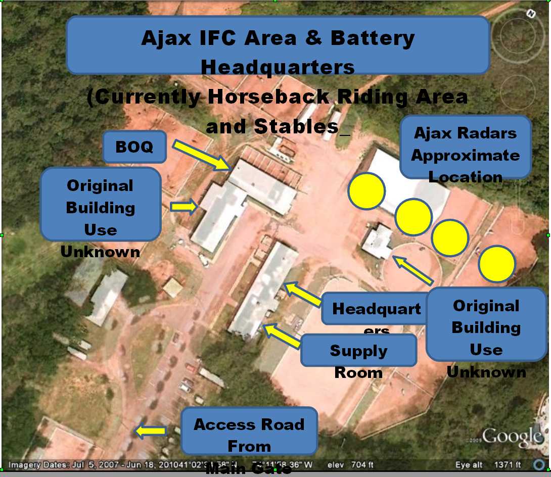
[(Piland, D) (July, 2010) Current status is
NY-94C (not converted to Hercules) is the stables and NY-93C, the Hercules
IFC has been destroyed and reclaimed by nature. ]
[(Bender, D) (June 2, 2010)
The north end of the IFC Area still has its 3 of its larger buildings intact, although
the interiors have been modified to turn them into horse stables, etc. There is a
latrine in one of the buildings (I believe it's in the barrack on the east side of
the Admin. Area) that I suspect looks pretty much like the army's "original equipment"
or close to it. I think it still has the original paint! At least that part of the site
has been "preserved"!
The southern IFC Area (no buildings or structures to be seen) still has some
foundation remnants including some related to demolished radar towers. Hard to see,
especially in the warmer months when the vegetation is up. Fences are still up or
partially up in some areas.
There is also what seems to be an old power connection to the local electric grid:
a structure composed of a couple of telephone poles and between them, IIRC, space for
transformers, some big switches, etc. This is off in the woods between the southern
IFC Area and the perimeter fence on the east side of the hill. ]
[(Piland, D) (May 28, 2010)
Historic Aerials shows that the IFCs for the 93 & 94 sights were about 0.3 miles apart,
with the second IFC south of the one we have marked. The second IFC was located at:
Lat 41.037451 , Long -74.198757 ]
[{Peabody, M} December 2005 - The link (below) is looking at,
well almost at NY-73 L. It is the Watchung Reservation about half mile east of NY-73.
The building complex to the north is Bell Telephone Laboratories, now Lucent Technologies HQ with
some of Bell Labs. ]
L - Campgaw Rd ((I) abandoned)
[(Piland, D) (June 2, 2010)
I found it interesting that the launch area had 6 sections, presumably 3 sections for each
System. After they deactivated the one system, they only deactivated two launcher
sections. On the 1966 Historic Aerial view, the three sections on the left have the
three topside launchers with each section and the lower section on the right has the
launchers also. The top two sections have no launchers.
So, the system that was left had the four sections, the maximum a system could
handle. Did any of the other double launch areas do the same thing? ]
[(Bender, D) (June 2, 2010)
The former Launcher Area was turned into a very upscale housing development. I visited
just after the development opened and on the border between two of the large homes was
an area covered with some brush and rough soil and a little bit of broken concrete.
Partially obscured by brush and debris was the base of a flagpole left over from the
old site! That was it. At least that was all that I saw. ]
[(Piland, D) (May 28, 2010)
I found the launch area using Historicaerials.com located at:
Lat 41.065452 , Long -74.188496 ]
[(Brown, R) (July 2005)
The two MsrMaps links here are those of another site. The coordinates of
Campgaw should be around N41? 03' W74? 11.9'. The present MsrMaps links for
NY-93/94 are 27 miles to the SSW of Campgaw Mountain. The following link is the top
of Campgaw Mtn, and I believe (But do not know for absolute certain) that this is
the IFC now with horse-riding areas and trails through the surrounding forest:
]
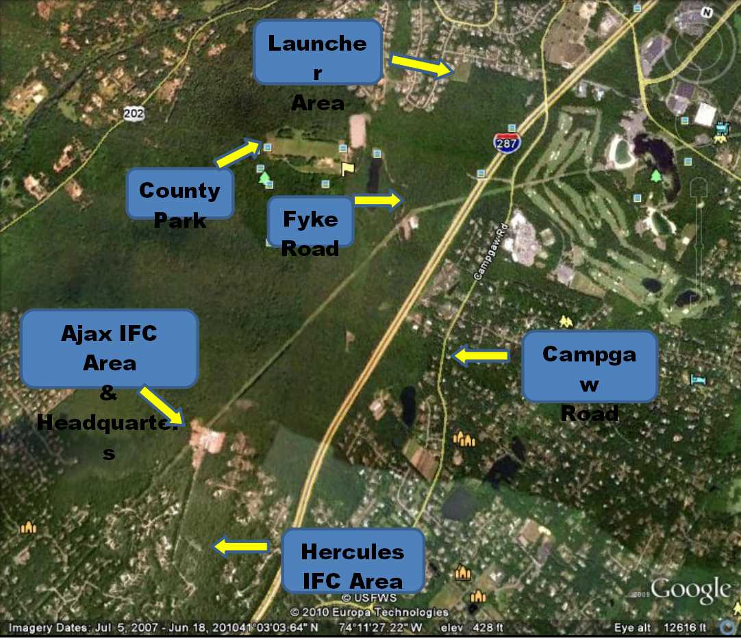
[{Bender, D} The launcher area on Campgaw Road
in Darlington was demolished about three years ago for a residential development.
Atop Campgaw Mountain, the IFC area (end of Shadow Ridge Road) remains
partially intact. The buildings of the administrative area are now used as
horse stables, tack rooms, storage and an office. They are painted in a
decidedly non-ARADCOM paint scheme of barn red with white trim! Foundation
remnants for radar towers and related buildings and structures are
visible upon careful examination.
This impressive "double" Nike site was known as the "Four Flags" site during
its later years, when Army National Guard units from 4 different states
manned the base. It was finally inactivated during 1971. ]
[{Friedel, G} {I was} BC during installation of HIPAR radar.
Launcher site is now an up scale housing development built on top of filled in pits.
IFC area is a county riding park with a horse in my BOQ room.]
|
PH-23/25
(double) | Lumberton
| Don Bender's previous web page,
Good pictures of PH23/25 before demolition,
Lumberton finds new use for old Nike site July 23, 2015 - spotted by {Page, T}
C - 2 S Mt. Holly, Newbolds Corner Rd ((I) Midway School)
[(Klco, Paul) March 2016, The IFC Area in Lumberton, NJ is now totally flattened.
Housing development to be built there, 23 homes. There is a Landscaping business on one side
of the road and still has two towers.]
Also see article ]
L - 2 S Mt. Holly, Newbolds Corner Rd ((I)Lumberton Township Municipal Complex)
[(Klco, Paul) March 2016, The LCA the barracks are gone,
but the Assy Bldg and the five pits are still there, 3 Ajax and 2 Hercules. Been down in them.]
[(Bender, D) (June 3, 2010)
[during Ajax to Hercules conversion] ... went from 6 to 4 active pits. ]
[(Murdock, S) GPS=39-57-40 074-47-51 ]
|
| PH-32 | Marlton |
web site,
[Don Bender's previous web page]
C - 0.5 N Tomlinson Mill (Road), Kettle Run Rd
[(Murdock, S) GPS=39-52-21, 74-53-39
L - 0.8 N Tomlinson Mill (Road), Evesham Board of Education)
[(Murdock, S) GPS=39-52-17 074-52-54 ]
[(O'Donnell, M) April 2003 - ... from the internet.
There was a housing development built. I cruised around and in the far corner there was a drain
pond and I noticed a chained driveway that lead to the woods. There was a dirt road but It had
concrete under it. I walked about 1/2 miles or so and found what was left of
the entrance gate. I saw a parking lot, and what was left of buildings and things similar to the sites
that you've seen, basically ruins. I went back farther in the
woods and found the launch area. I demolition company (their sign [Hargrove]
was placed on a tree) had covered the elevator doors with asphalt. The curbs
were still there. The stair well doors were missing but there was a huge
block of concrete in front of it and you can see on the sides that it was
filled with water. ]
|
PH-41/43
(double) | Berlin /Clementon
| [Don Bender's previous web page]
C - Williamstown Rd. ((P) private owner)
[(Murdock, S) GPS=39-45-05 74-59-59 ]
L - Cross Keys & Berlin Rds, N of Atlantic City Expressway ((P) W. Hargrove
Demolition)
[{O'Donnell, M} (November 2003)
...demolition has begun. I had me buddy fly me over and all the elevator
platforms were ripped out. I went there Saturday and all the stairs that had
been sealed by welded plate had man way size holes cut in them. I went down
all six magazine rooms. Some had murals on the depicting missiles with animals.
I remember one said foxtrot with a fox and a missile???
(April 2003) I went there three times
(as expected, I had to let myself in). This is a double site and it looks like
time stood still. To my dismay the launch site was recently sold to the township
and is expected to be demolished. I had emailed the governor twice to find out
how to get this declared a historic site. I never received an answer. ]
[(Murdock, S) GPS=39-44-29 75-00-07 ]
Housing -
[(Murdock, S) GPS=39-45-10 95-00-01 ]
|
| PH-49 | Pitman, NJ
|
[Don Bender's previous web page]
C - 1 WNW Pitman, Richwood Rd ((P) Glouchester County Christian School)
L - Pitman-Jefferson Rd ((P) Kraemer Construction Company)
[(Murdock, S) GPS=39-44-37 075-10-05 ]
|
| PH-58 | Swedesboro
|
[{Larsen, D} (April 21, 2020)
A few years back I spent some time at PH-58 when the District performed BD/DR work under DERP-FUDS.
It is clear to me that, at one time, PH-58 was one of the best untouched Nike sites you'd find anywhere.
Unfortunately, as you see in some of Richard Lewis' excellent photos, the ravages of time and neglect have taken their toll,
and most buildings are now severely dilapidated. When I visited, it was a delight to find everything was still standing,
although some structures just barely. Parts of the sites are pretty overgrown as well.
I was PM for the BD/DR effort that involved removal of structures that were deemed hazardous by New York
District personnel who had visited over 15 years before and created the original project recommendations.
By the time I got there, most of the remaining structures had also
become hazardous. These did not qualify for our project because the condition did not exist at the time of property
turnover (or at least at the time the first NAN FUDS site visit occurred). We did find some open manholes, etc
to deal with as falling hazards and some elements of the wastewater treatment facility represented drowning hazards.
The hydraulic systems in the three pits were purged and concrete planks were placed across the elevator at each
of the three pits. Before any of the BD/DR work began, we took HABS photos of the areas.
I noted at PH-58 that only two of the three pits were converted to Hercules. You can confirm this by observing the
position of the fence that defined the exclusion area.
In terms of what's left there, the four radar towers at IFC are in pretty good shape all things considered.
We had to attach plates to the lower ladder segments to render them not climbable, but that is also a reversible measure.
At the launch site, the dog kennel is in almost time-warp condition if a bit of overgrowth would be removed and
fresh paint applied. You can even read the dogs' names stenciled on their huts: Teddy, Mac, King and Prince.
If you know of anyone restoring a Herc launch area, they might want to inquire about rescuing and relocating this kennel.
I will send out a few more shots of PH-58 in a separate email. ]
[ A 2012 video tour of the site - 5.5 minutes - from Edward Getley ]
[Don Bender's previous web page]
C - 1 NNE, Paulsboro Rd & US 322 ((I) private owner)
[{Page, T} (April 18, 2020)
For Sale: Former Swedesborro, NJ Nike Missile IFC Site (PH-58C) --- only $1.8M with swimming pool. ]
- Also
- and pictures of current condition
[{Gale, M} (February 2005) I was amazed to find an intact and
very weathered control area. I'm not kidding, all radar towers, too many buildings to name
and the guard shack at the main gate. little if any vandalism showing. Relatively undisturbed.
So the status should remain intact as of this date. The location is NE corner Gilchris Drive
and Paulsboro Rd. Most complete control area I ever visited. I have no new info on launch
area status. Private owner posted no trespassing and means it according to locals. I may try
to get an appointment unless you know anybody who tried. A local man told me it is in good
condition but I can't confirm yet. Sorry no GPS or MsrMaps info yet. ]
L - 1.4 NNE, off Paulsboro ((P) private owner)
|
| PH-64DC.pdf | Pedricktown
| Missile Master
[Don Bender's previous web page]
article by Don Bender
More details at Radomes.org
[{Page, T} ... former Army long-range radar facility
at Gibbsboro, NJ (once an annex of Pedricktown, PH-64DC). The radar site was
later transferred to the USAF, and became Gibbsboro Air Force Station (Z-63),
home to the 772nd AC&W Squadron (later 772nd Radar Squadron). ]
[{Tow, J} Of note the AADCP for the Philadelphia sector
was at Swarthmore College, prior to moving to Pedricktown, which was an old Army
Ordnance storage site.]
|
| Camp Kilmer |
Edison | Direct Support Shop - 8 miles west of Perth Amboy |
go to top
| . | NewMexico
For locations and views, fly in using
Google Earth thanks to
NikeSiteSearchers
|
WA-10 - Walker AFB - Roswell
WA-50 - Walker AFB - Hagerman
|
| Designation
| General Location
| Detailed Location (Current Status)
|
| Walker AFB Defense Area | .
|
[{Morgan, M} As a SAC base, it was determined that Walker should be
defended by a Nike Hercules battalion. In one of those
remarkable instances of military planning, the 6/2d was
activated at the AFB on 20 April 1960; it was then
inactivated on 25 June 1960, without ever being declared
operational.
Two sites were assigned, WA-10 and WA-50, and I'd always
assumed that neither were completed. Man, was I wrong...]
The Walker sites are of a different design from the standard Nike installation; the
launchers are above ground, with the missile pads mounted in earthen bays.
There are two bays per earthwork with two missiles per bay, resulting in
12 Hercules at each site. I have no idea how they managed to reload or where
they might have stored the reloads.
The crew shelters are sunk into the embankments; I went down into one at the
WA-50 site and they measure about 10x10
ft. To get from the shelter to the launcher, the crewmen had to climb over the
embankment.
For lack of better, I refer to this style Nike launch site as a SAC design;
I haven't been to the other
Hercules-only SAC sites so I can't say for sure they were all built to this design.
Nike Hercules sites built for SAC
bases during 1959-60 were at Barksdale (BD), Bergstrom (BG), Dyess (DY),
Lincoln (LI), Offutt (OF), Robins (R) and Turner (TU). Malmstrom and Mountain Home
were scheduled to get Herc but deployment was canceled following site surveys.
Schilling had facilities built but, like Walker, was inactivated prior to going
on alert (16 May 89).
|
| WA-10 | Walker AFB - Roswell
| C - 10.5 E Roswell, 2 N US 380 ((I) NMArNG Military Academy)
[{Bossie, Clifford } (April 2009) Last week I visited that site
and took a few photos which I have uploaded to a page I built on the subject: http://www.angelfire.com/dc/jinxx1/WA10/WA10.html ]
[{Doubleman, P} (October 2004) I think that the IFC area was once used by
the NM National Guard as a training facility, but is now abandoned. The administrative and living area
buildings (Admin., Barracks, Mess Hall, Generator, etc) are in remarkably good shape. There has been
some vandalism though. However, you will get a good idea of a typical administrative (IFC) area layout.
I think that the barracks housed both the IFC and Launcher Area folks (no family quarters though).
Looking at the MsrMaps pic of the IFC Area you will see a faint circle just north of the fence
line. That is the tie down points for the HIPAR dome. It looks as if the HIPAR wasn't on a pedestal. ]
[{Murdock, S}GPS=33-25-31 104-20-50,
]
L - 11.5 E Roswell, 2 N US 380 ((I) NMArNG training site)
[{Doubleman, P} (October 2004) The Launching Area is in great shape
(no equipment though). The infrastructure is all there (fences (exclusion and limited area), section
earth works (Alpha, Bravo, & Charley Sections) exclusion area gate house, Warhead Building and earth
works, Missile Assembly Building, dog kennels, Ready Building and limited area gate house. Vandals
have cut holes (very handy) in the limited area fence at strategic points to allow entry. The gates
were locked. There were even red footprints painted on the Missile Assembly Building hard stand that
were used to tell the troops where to stand for their formations. Gosh, it brought back old memories.
One thing that I didn't see was any guard towers. Again, the GPS coordinates were right on. Some
better driving directions: Go East out of Roswell on US 380 toward the Bottomless Lakes State Park.
Where you would take a right to go to the state park... go left toward the NM National Guard Training
Facility (it's really abandoned). Follow the dirt road to the IFC Area. Take a right at the IFC Area
to get to the Launching Area. ]
[{Murdock, S}GPS=33-26-10 104-20-07,
]
|
| WA-50 | Walker AFB - Hagerman
| C - 13 S Roswell, 5 W US 285 ((I) Roswell Correctional Center)
[{Doubleman, P} (October 2004) The IFC area is now a Detention Facility.
Consequently, you are unable to see the original buildings very well. The GPS coordinates are "right on".
Here are a little better driving directions. Go South on US 285 out of Roswell toward Artesia. Look for
the Detention Facility sign (on the right) about 13 miles south of Roswell. Turn right and go toward
the Detention Facility. Keep going... you won't get stopped by guards at the detention facility. Once
you enter what looks like the entrance to the Detention Facility compound, turn left and go over the
cattle guard. You will see the earthen bays of the Launching Area about a mile away. Drive down the
runway to get there. ]
[{Murdock, S} GPS=33-08-25 104-32-32,
]
L - 14 S Roswell, 5 W US 285 ((P) abandoned)
[{Doubleman, P} (October 2004) We found that WA-50 (Launching Area) is
pretty much gone except for the earthen bays. It looks as if the buildings (Missile Assembly,
Warhead, Generator, and Ready) were blown up. ]
[{Murdock, S} GPS=33-07-35 104-32-38,
]
[{Morgan, M} The launch area is one mile south and can be seen from
the control area. To get to it you drive over a cattle guard and down the middle of a runway;
apparently WA-50 was built
on the site of a former Roswell AAF aux field (# 3). The launcher is wide open (watch out for cows); the
buildings have been demolished but the embankments are in good shape (17 May 89).
|
go to top
| BU-09 | Ransom Creek/
Millersport
| C - Smith Rd, E of New Rd
[{Willis, N} Intact
BU-09's control facility is the town of Amerst's Record Department. The launch
facility is property of the Amherst Police Dept.]
[{Murdock, S}GPS=43-03-14, 78-43-11,
]
L - NY 263, N of Smith Rd (Town of Amherst)
[{Willis, N} Intact]
[{Gilliss, D},
Photos ]
[{Murdock, S} GPS= 43-03-50 78-42-38,
]
[{Talley, J} Veritay is a weapons R&D outfit that
operates out of the BU-09 launch site. For 9 years I worked there in the
missile bunkers ~ we used them as underground firing ranges. I spent
countless hours refurbishing hydraulics and ventilators and the like. Other
than patching smaller hydraulic pumps into the lines, we used (and they
continue to use) the doors and elevators to move material in and out of the
solis and we used the original ventilation system to vent the gases from the
various ordnance items we set off. ]
|
| BU-18 | Lancaster/
Milgrove
| C - Pavement Rd, N of Walden Ave ((I) Lancaster Town Center
L - Ransom Rd & Walden Ave ((P) First Squared Element Co.
[{Frost, C} I am the Fire Chief of the Millgrove VFD. in Lancaster, New York.
The old Nike site in out district still has the elevators operational.
A constriction firm uses the underground storage area to repair their equipment.
I was down in one of the underground levels for a EMS call this past winter.
The location of the elevator site is at the corner of Ransom and Pepermint Rds.
in the town of Lancaster, New York ]
[{Murdock, S} GPS=42-55-50 78-35-50
]
|
BU-34/35
(double) | Orchard Park
| C -Transit Rd, N of Mile Strip Rd
[{Page, T} The Topo Map is perhaps more informative about how the IFC site
once looked. ]
[{Murdock, S} GPS=42-47-34 78-41-59 ]
L - end of Willardshire Rd, E of Transit Rd (HGM Land Corp.)
[{Wroblewski, B}
Jan 2000, The control area is nothing
but grass and concrete while I could find absolutely no trace of the launch
area. ]
[{Page, T} I'm not absolutely positive on the launcher site; it looks right ...
but tell me what you think. Thanks.]
[{Murdock, S} GPS=42-46-34 78-40-08 ]
[{Talley, J} (sent by {Page, T})
I caught your comment on Ed' s Nike website ... , sort of questioning where the
launch site for BU34/35 was located. You do have the right photo. This is actually
located in the Town of Aurora (NY)... the road that comes down from the top of
the photo is N. Davis Road and the cross street is Willardshire Road
(I used to be an officer in the East Aurora Fire Department and worked for a
company that operated out of the BU-09 launch magazines in East Amherst...
as a hobby I went and found all the sites in WNY).
Anyway, the building right opposite the N. Davis/Willardshire Rd.
intersection has been converted to a house/residence but it is unmistakable
as either the admin building or the barracks. At one time I found an aerial
photo of the area from around 1965 and saw that the launch area was located
down by the creek bank in the lower right area of the photo you provided the
link to. It was covered over with dirt in the 1970s after the air vents were
torched off. Best regards, Jim Talley, Shelburne, Vermont ]
|
BU-52
(double) | Hamburg
|
C -New Lake View Rd, 2 E. Heltz Rd
L - New Lake View Rd, 1 E. Heltz Rd
[{Dart, D} ... slightly intact. The buildings are still standing,
but the launch area is covered by a Bike track, and the whole
site was converted to the Hamburg Town Park. There are Town Offices where the
control room use to be.]
[{Wroblewski, B} 1-16-00.
the launch area still exists and is pretty much intact. It is owned by the
Hamburg DPW and is off limits. About two seconds after I took those
photographs I was escorted off the property.
[{Murdock, S} GPS=42-42-37 78-54-07
]
[{Markert, T} Jan 2001 - . I was able to
find all the missile silos. The town highway dept. has stuff piled around the
entrance ways and escape hatches, but they are still there. I hope to get a
series of photos done in the spring. Many of the base buildings and the
adjacent radar platforms are still there. ]
|
NF-03
(double) | Model City
| C - Porter Center Rd & Langdon Rd
[{Housman, J} (Feb 1, 2010) This site is 94 acres.
The main road in was part of the rail line that fed the storage bunkers when it
was Lake Ontario Ordnance Works. What is there is the assemble building
generator building, very little of the fueling station, one building on
the missile bunker site and one guard house. some utility poles.
concrete slabs were the barracks were. There is nothing left of the Air
Force Radar Test Site. The property from my research was not a dumping
grounds, but you never know. The property sold for about $150,00.0 in
2007 and is again back on the market, and I do not know the price. There
isn't any bunkers that can be entered, They are welded shut except for
one. All have standing water lots of water. Have pictures taken in 2007.
Not a lot to see. Across the road the property is held by the National
Guard for training . One small section is a weather station and Town of
Porter uses the water tower.]
[{Willis, N} Site NF-03's control area
is on private property, I wasn't able to get any good looks at it.
However, there are signs like fences with barbed wire facing outwards, and
bunkers.]
[(Murdock, S) GPS 43-13-03 78-57-45 (updated)
Topozone ]
L - Balmer Rd & Porter Center Rd
[{Housman, J} Aug 2007 - Starting bid $100,000.00 No bids so far for a good reason.
Toxic waste every were. This being a part of 7500 acre Ontario Ordnance Works . Government has lied to us
about use of this land. They still own a large section across form this site..
You can check out this auction at WWW.auctionrp.com
[http://www.auctionrp.com/auctions2/default.cfm?action=itemInfo&id=766] ]
-
[{Page, T} Aug 2007 -
"Nike missile launch site up for auction in Niagara County" ]
Thanks go to Bill Leach (MSgt-r) for mentioning this story in the "Guestbook" of our website, http://www.radomes.org/museum/. (I worked with Bill at Hancock Field and Griffiss AFB, NY, back in the 1981 - 1984 time frame.)
[{Willis, N}NF-03's launch area was an Air
Force installation (signs with Air force on them) with two large radars facing
eastward. the facility has signs that it was abandoned recently. There is
equipment and signs that look a few years old. We're not sure but we think
that a chemical company might own it, but we're not sure. Maybe the launch
and control areas are mixed up? ]
[{Dart, D} NYARNG uses it for their drills...well, part of it anyway, across the street
from the City.]
[{Murdock, S}GPS=43-13-43 78-57-43 (updated)
(later known as Youngstown Test Site, USAF): ]
|
NF-16
(double) | Sanborn
/ Cambria
| C - Shawnee Rd, S of Upper Mountain Rd ((I) BOCES)
[{McDonald, D} (Sept 2005) Visited old base on August, 2005
found and toured fire control site radar bases still there, generator, hipar, ttr tower and
most of out buildings. Barracks were remodeled and are used as offices for traffic andsurvey control .]
[{Herbert, E} NF-16's control area is still abandoned and intact.
No one occupies it. The sign is still there, but i forgot the name of the site.]
[{Murdock, S}GPS=43-09-32, 78-50-26, Franklin Transportation Co.
]
L - Upper Mountain Rd & Cambria Rd ((I) Cambria Town Hall; vehicle maintenance yard)
[{Dart, D}The most in-tact site we have in WNY. The launching area is
overgrown with weeds, and the billets and other buildings have been converted to
Elderly Apartments(go figure) The old medical building still has the Med symbol on
the wall of it. I went to look at the IFC and I talked to the maintenance guy
of the business there, and he said the govt. came a couple years ago to make
sure the place was safe from radiation. He said that almost all the original
signs are in the buildings, also. (I saw one that was a radiation
warning.....made me nervous) But they said I can come back any time I want
and take pictures and they will try to get me underground. more to follow on
the ifc. the launch site is great also. Everything is about 50-75% in-tact.
All the buildings are still standing. I saw what looked like a power
room/building that still had the key-pad entry system on the door...but all
the doors are open to the buildings...I'm in the process of trying to track
down the owner to get permission to walk around and take pics.
[{Murdock, S}GPS=43-09-45, 78-49-30]
[{Roberts-Abel, C} ... is just off of Old Shawnee Road,
south of Saunders Settlement Road. I could see the site from Rt.31(Saunders Settlement).]
|
| NF-17DC | Lockport AFS
| LOC: Shawnee Rd/NY 42S, S of Sanders Settlement Rd
CUR: (I) private owners; portions abandoned
More details at Radomes.org
[{Etten, S} (March 2006) - to Tom Page -
... If you are interested in seeing any of the images they can be found at
http://institutionalgreen.com/gallery/usaf. I also wanted to make sure
it was ok to use the historic images from your site on mine. ...
Current conditions of the site, FYI, the missile master building used to
be locked tightly, but was broken into sometime in 2005. I was dying to
get inside but I was always leery, as it appears to have burned, and it
smells very unhealthy. Unfortunately, it is now locked tight again, I
guess I missed my chance. The dormitory building 113 was in very bad
shape, floors caved in, etc, and was demolished in 2005. I can't tell
what the other few buildings left were, aside from the power house
(still standing, seems to be in good shape) and the gym (also still
standing).
One of the more intersting parts of one of the buildings is this mural.
Very large, too large for my camera haha
http://institutionalgreen.com/gallery/albums/usaf6-16-04/command08.jpg ]
[{Page, T} (January 2006) The AADCP there definitely operated an AN/FSG-1 Missile
Master originally. See http://www.radomes.org/museum/documents/LockportAFSarticle.jpg.
[{Morgan,M} ... housed an AN/GSG-5 BIRDIE
(Battery Integrated Radar Display Equipment), ARADCOM's answer to a SAGE CP.
From the design of the structure - which I managed to visit in Oct 92 - it
would appear the building originally housed an AN/FSG-1 Missile Master,
capable of directing the eight original Ajax sites in the Buffalo/Niagara
Falls Defense. I haven't confirmed an FSG-1 installation, but do have records
that state Fort Niagara housed a manual Army Air Defense Command Post
(AADCP). My guess is, with the merging of the two defenses and replacement of
Ajax by Hercules, ARADCOM probably bypassed the FSG-1 and went directly to a
BIRDIE. MK.]
[{Murdock, S}GPS= 43-08-24 78-50-00
]
|
| NF-41 | Grand Island
| C - S of White Haven Rd ((I) Town of Grand Island Nike Base Park/
Senior Citizen Center)
[{Murdock, S}GPS=43-01-06 079-00-48,
]
L - Staley Rd & West River Parkway ((I) Eco Island Ecology Reserve)
*NOTE: Former dual NF-74/75, redesignated to NF-41 following conversion to Hercules
[{Piland, D} (June 4, 2010) My first clue was the Launcher area.
Anytime you see a launcher area with more than four sections, it is either a double or
has two different site numbers. I don't recall seeing a launcher area with four sections
that was originally built that way. The Ramsey / Darlington / Mahwah, NJ - NY-93/94
- Launch Area is the only one that I recall that deactivated only two sections and left four.
The 1966 photo of NF-41L indicates that they deactivated three sections and left the other
three operational. ]
[{Murdock, S}GPS=43-00-32 079-00-56,
]
|
NY-03/04
(double) | Orangeburg/
Mount Nebo
| Don Bender's previous web page
C - Nt. Nebo, W of US 9W ((P) City of Orangeburg; park)
[(Brown, R) (July 2005)
The complex on Mt Nebo is Rt 9w and Piermont on the right side. The "Y" shaped road is "US Army Rd"
in Street Atlas mapping software. It is accessed from S. Tweed Rd, entrance coordinates
on S. Tweed are : N41? 03.133' W73? 55.447' ]
[(Murdock, S) GPS 41-01-58, 73-57-05 ]
L - Palisades Parkway & NY 303 ((I)USAR Center; 812th Military Police Co.
[(Brown, R) (July 2005)
The launch site location was in the Northeast quadrant of the Palisades Parkway
and Route 303 intersection, NOT the Southeast quadrant.
Coordinates for the Entrance on Rt 303 are: N41? 02.338' W73? 56.749' ]
[(Murdock, S) GPS 41-02-16, 73-56-29 ]
[{Mandeville, P}Launch area is intact except the missle pits have
been cemented over and is used for the reserve centers motor pool.
all other site buildings are intact.]
|
| NY-09 | Kensico
/White Plains
| Town of Harrison
Don Bender's previous web page,
[{Greer, L} North of White Plains, off of Route 22. I forget the name of the
little road the IFC site was off of, and I'm even vaguer on the roads to the launcher area.
It was immediately East of the Kensico Reservoir. ]
[{Nagl, R) ... the entrance to the launch area,
which is on Park Lane, between Indian Hill Road and Burns Road,
and near Woodmans Cove on Rye Lake, in Harrison, New York. ]
[{Morgan, M} NY-09C - 41-03-22/073-55-43,
NY-09L - 41-02-16/073-56-34 ]
|
| NY-15 | Ft. Slocum/Hart Island
|
Correction History Web
page, (Local Copy)
[Don Bender's previous web page]
[{Page, T} (Sept 2011) In case you have not seen this ...
web site ]
C - Davids Island ((O) City of New Rochelle; private development planned
[{Larsen, D} (June 2014) control site was on David's Island in New Rochelle
and all structures there except Fort Slocum's early Abbott quad mortar battery Haskin/Overton have been razed. ]
[{Page, T} (Sept 2011)
I had been having difficulty discerning where the IFC radar towers once stood.
The aerial image shows that the line of radars was mostly south and east of the
southern-most mortar pit. From this photo, I was then able to 'see' the radar towers
in the historic aerials imagery. Here's something else of interest:
picture 1,
picture 2.
L - Hart Island ((O) private owner)
[{Page, T} (Jan 2020)
short newpaper article w pictures]
[{Larsen, D} (June 2014) ... access is strictly controlled by the
NYC Department of Correction. Because the launch area is seldom visited, the two pits are in
OK shape considering their age and neglect. Both had two ladders for personnel access;
there are no steps. The elevators were left in the raised position. ...
Much of the area the launch site occupied is very overgrown with lots of poison ivy. ]
This was an Ajax site that was not chosen for improvement in part due to the higher cost of operating on a pair of islands.
|
| NY-20 | Lloyd Harbor
/Huntington
|
[Don Bender's previous web page]
C - (private owner)
[{Morgan, M} NY-20C - 40-54-23/073-27-33 ]
[{Page, T} Based on Mark's lat-lon data, here is
(used to be) The topo map shows buildings consistent with what one would expect.
L - (private owner)
[{Morgan, M} NY-20L - 40-53-55/073-28-08 ]
[{Page, T} The topo map shows one long L-shaped building at this location. |
| NY-23 | Hicksville
/Oyster Bay
|
[Don Bender's previous web page]
C - W of NY 107/Cedar Swamp Rd ((O) housing development)
[{Morgan, M} NY-23C - 40-48-22/073-33-37
The control site is roughly a mile to the WSW, immediately west of
NY107/Cedar Swamp Road on top of the only hill in the area. Again, it's
surrounded by houses, VERY expensive houses. I walked up around the yard of
one of the residences to find that the summit is enclosed by chain link
fencing. Inside the fence it's completely overgrown except for some patches
of asphalt pavement. I looked for a gate or some access, couldn't find any,
and departed for the next stop (24 Feb 92). ]
[{Page, T} Okay, based on Mark's lat-lon coordinates.
I earlier looked at this exact location (the topo map looked somewhat right),
but to me the aerial photo was very inconclusive). ]
L - W of Brookville Rd, N of NY 106 ((P)Nassau Board of Cooperative Education;
Brookville Nature Park and Outdoor Education Center
[{Siegfied, W} (August 2012)
The launch area is still as previously described.
Stopped by after 5 on a weekday and no one was around. The elevators
and vents are concreted over. Two are covered with trees and brush and
one is covered with dirt. Several hatches remain in the brush and seem
to be welded shut. One of the concrete vent caps is broken in the dirt
area and, when removed, provides access to the underground magazine.
Since I was alone and there were no ladders I didn't go down. Shimmying
down and up didn't seem like a good idea. It appeared to be dry and a
rock tossed down elicited a dry, cavernous echo. ]
[{Morgan, M} NY-23L - 40-48-42/073-32-55
The launcher for this former Ajax site is immediately west of Brookville
Road north of NY106 between Jericho and Oyster Bay. The area if full of
expensive houses; looking to the left in and around the "Long Island
Lifestyle" I noticed one paved road that went back a ways, drove up it and
yes: everyone went to GQ when the patrol car rolled up ("I'm from the
government and I'm here to help").
23L operated Ajax from 1955 through 1963 under C/66th (/55-9/58), C/1/55th
(9/58-6/60) and NYaRNG B/1/245th . The site had three magazines for a total
of 12 launchers.
What's remaining are the launch pads, with elevator doors concreted over,
and the assembly building; the berms have been leveled. The owner is the
Nassau Board of Cooperative Education, which uses the site as the Brookville
Nature Park and Outdoor Education Center. I ended up giving the center
director a quick course on Nike and promised to send some more information
later. The site may be surrounded by houses but it definitely feels like it's
out in the woods. (24 Feb 92) ]
|
| NY-24 | Amityville
/Farmingdale
| [Don Bender's previous web page]
C - (USAR Center)
[{De Marco, P} Mar 31, 2009 "April 1, 2009 - The IFC area for site NY-24 has
been totally obliterated. There is nothing left of the site except the fence. They are in
the process of building a large warehouse type of building on the site." ]
[{Azzollini, M} Entrance off Baiting Place Road (west side)
just south of Allen Blvd, Farmingdale. 5 radar tower platforms remain, plus most
original buildings, fencing, light posts and pavements.
]
[{Morgan, M} 40-42-50/073-25-35 ]
L - Zahn Airport; Farmingdale Rd/NY 109 (Zahn Airport)
[{Plante, Ron} Sept 1, 2022 -
Former North Amityville missile site (NY-24L) may be reinvented for sports, community activities.
Link to newpaper]
[{Azzollini, M} Entrance off Albany Ave (west side) just
south of New Highway, North Amityville. Remains are same as described by
Mandeville, P. ***Note that the town is North Amityville, --not Amityville.
Zahn's Airport was demolished about 15 years ago and was made into
an industrial complex and NEVER had anything to do with the Nike site,
--but it was close to it (across the street from the launch area about
300 yds away to the east).
]
[{Mandeville, P}The missle pits are cemented over and used
as a motor pool. all other buildings are intact as well as the double fence and
original lights.]
[{Morgan, M} 40-42-30/073-24-20 ]
|
| NY-25 | Rocky Point
/Brookhaven
| [Don Bender's previous web page]
C - between Wading River Manor Rd & NY 46, S of NY 25A
((P)abandoned)
[(Murdock, S) GPS 40-57-01, 72-52-07
]
[{Morgan, M} The site straddles NY25A between Wading River
Manor Road and NY46; the
launchers are to the south with control site on the ridge to the north.
NY-25 was operated by D/505th ( /57-9/58), D/3/51st (9/58-6/64) and NYArNG
B/1/244th (6/64-6/71);
When I pulled into the actual control are there were a couple of men
working; they identified themselves as being from the Corps of Engineers,
working on PCB disposal. You know, I thought there was something funny about
their full body suits ("Excuse me sir; you haven't been breathing have you?").
All of the buildings and radar plats are still in place and I was able to
get several good shots. Generally, though, the site is crumbling into the
ground, with the usual amount of graffiti and vandalism. As a Hercules site,
NY-25C was equipped with HIPAR; it addition the site had SMFU and RRIS (24
Feb 92). ]
L - between Wading River Manor Rd & NY 46, N of NY 25A
((P) Rocky Point USAR Center
[{Mandeville, P} launch area is intact,was able to go into the pits,ie
missle magazines. good condition.]
[(Murdock, S) GPS 40-56-26, 72-52-20,
Topozone ,
[(Murdock, S) Housing, 40-56-51, 72-52-12
< ]
[{Morgan, M} it was a "2 1/2" magazine site with
10 launchers like
S-43 out in Seatle. The launch site is now the Rocky Point USARCEN, complete
with big modern bulding and plans to tear down the assembly building. The
launchers are now used for motor pool parking. I was able to get a quick
description of the site from one of the Army Reserve technicians, took a
couple of photos and proceeded down the road. units
The road up the hill has several units of Army housing lining it, which
was a unique touch; most of the Nike bases I've visited have their housing
elsehwere. The housing is now used by Brookhaven as a shelter for the
homeless; the development is named the "Harry Chapin Inn." Harry Chapin was
a big champion of the homeless in his native NYC well before it became
fashionable; it's hard to believe it's been ten years since his fatal car
crash on the Long Island Expressway. What was wried was just before I drove
in the radio station I was listening to played "Cat's In the Cradle." There's
your signpost up ahead... (24 Feb 92). ]
|
NY-29/30
(double) | Lido Beach
|
[Don Bender's previous web page]
another web page
(occupied 1955-1963)
C - end of Blackheath Rd, Lido Beach. - (O) nature park
[{Azzollini, M} CONTROL AREA: (located at the northern end of
Blackheath Road, Lido Beach, NY.) Remains: 4 complete buildings, 1 building
foundation, and the post's dedication monument (dated 27 Nov. 1957). The control
area property is now being used (I assume owned) by the Long Beach School District.
The buildings described above (now refurbished) comprise the school district's
Pre-K facility. I believe the adjacent High School rests on land where the
radar units were located. ]
L - N of Lido Blvd., (I) Long Beach School District
[{Azzollini, M} LAUNCH AREA: (located on the north side of Lido Blvd,
between Prescott St. and Bay Lane, Lido Beach, NY.) Remains: a mostly intact site.
The dual bank of missile silos and launch doors still remain, but the doors have
been secured( when last checked about a year ago). Many of the original structures,
fencing, pavement, light poles, etc, still remain in various amounts.
This site is also being used (again, I assume owned) by the school district. The
remaining structures (refurbished) now comprise what's referred to as
the "Nike School".
] |
| NY-49 | Ft. Tilden
|
[Don Bender's previous web page],
[{Binder, Michael} Ft. Tilden.pdf
1964 plan of Ft. Tilden. The Nike launch area is in blue; the two control areas, in green. ]
C - Rockaway Point Road (National Park Service; Gateway National Recreation Area)
[{Siegfied, W} (August 2012)
I've always had the best results asking permission.
Unfortunately this was not the case at Ft. Tilden. The Park Rangers
were so focused on running off people parking for the beach that they
didn't believe me when I said I wanted to look at the old military
facilities and take a few pictures. One Ranger actually said, "how do I
know you're telling me the truth", and threatened to tow my car if I
went to the beach. Rather than debating the point I asked where we
could park if we wanted to walk around the park and take pictures. He
said we'd have to park outside the park today but that there was no
prohibition against taking pictures. I considered that permission. : )
We decided to park at the fishing area west of the main gate where no
permit was required and walked in past the Harris gun emplacements. I
guess they have their concerns but friendliness towards a few Va
tourists was not one of them.
Due to a lot of overgrowth and fencing, I was unable to identify the
IFC area with the time and materials I had available. ]
[{Azzollini, M} located at the southwest portion of the park by
Parking lot #1. One building remains, along with several concrete radar pads, some
original fencing and some pavement, ]
[{Stephens. C}IFC converted from two (2 - dual site) to one
(1- single site)]
L - Rockaway Point Road (National Park Service; Gateway National Recreation Area)
[{Siegfied, W} (August 2012)
... is fairly intact but with substantial overgrowth
throughout. Best to park at the fishing parking area (be sure to comply
with permit requirements as they vary throughout the year) on the west
side of the park and walk in past the overgrown and graffiti covered
Harris gun emplacements. Due to the intensity and focus the rangers had
towards beachgoers we had no worries about them noticing us. The front
entrance area is used as a storage and maintenance facility. A short
walk on the overgrown road back to the exclusion area revealed many
buildings in disrepair and overgrown. All of the magazines are filled
in and covered except one which is open and fairly dry. One hatch has
the normal original ladder and the other has a long, homeowner grade
extension ladder. Nearby, at the surface, a universal launcher resides
in the weeds. There is much construction equipment and materials and a
variety of random junk that clutter the surface of the site. It's
probably a good idea to ask permission when the Rangers are having a
better day. ]
[{Azzollini, M} located in the south/central portion of the park.
It is accessed from the "truck maintenance area" only. (2000) I believe the
Nike Hercules is no longer on display. I could not find it yesterday and the
parks people did not know of any at the site.]
[{Bender, D} There is a display of a Nike Hercules with out booster.]
[{Mandeville, P} Launch area is partial, some buildings in use,actual missile
pit area is cemented over except one pit which is still open if you want to go down
a rusted ladder. National park service gave us the brief tour.] |
go to top
| . | Norway
| Google Earth
Norwegian Nike sites from Ren� Kiefer
Admin and Operator cold-war.de |
| Designation
| General Location
| Detailed Location (Current Status) |
| Nike Battalion Headquarters | Linderud in Oslo
|
{Søbakk, O.} (May 2003) located at Linderud in Oslo,
the camp is still in use, but is now the home of the Army academy (something
similar to the WestPoint) ]
|
| Asker batteri | Oslo |
{Austersl?tt, T}
about 40 km to the southwest of Oslo at Rustan. Rustan
(or Rustaden) is the name of the farm that once was at the site. It is
on small scale maps of the region only.
If you follow this link and view the map
here.
Also worth noting: the Home Guard camp was closed down a couple of years ago and the buildings sold.
I don't know whether the missile site itself still is a military arear or not. Rustan is just to the southeast of
the lake connected with the blue line to the number 285 (on the left). The red
line to the south is the highway E18.
To get there, drive to Sandvika,
take off to Tanum, follow Vestmarkveien (a road) and park at the gate before
Vestmarksetra.
From there it is a 5km walk on paved road. It is a publicly accessible area used by many
hikers, hunters and the like, but the premises of the old site is fenced in.
Signs on the fence explicitly forbids taking photographs.
... site is still largely intact with barracks, hangars/magazines, roads, launcher
pads and some more things I have no clue what is. Although all exterior
equipment have been removed, the concrete pads are still there.
There is a Nike Ajax (with booster) on display between the administrative
buildings at Rustan, located about 1km from the launch pads and the magazines.
See http://break-left.org/nike/.
It was operative until 1991 (not sure about
this, but RNoAF closed down two NIKE-sites in 1991). The site is currently
operated by a local defense unit (remotely similar to the US National Guard) as
a training complex. Thus, the premises are still military and closed off to the
public - it's completely fenced in.
{Søbakk, O.} (May 2003) -Asker battery, located
in Asker, is the only which is still in military use by the local defence,
called Heimevernet (Home Guard) ]
| Nes Batteri | 40 KM north of Oslo |
{Søbakk, O.} (May 2003) -Nes batteri, located about
40 km North of Oslo, not far from the Gardermoen airport, the site is now for
sale, check it out on www.skifte.no ]
|
| Trogstad batteri | ?stfold fylke (county) |
{Søbakk, O.} (May 2003) this site is/was located
in ?stfold. The barracks are in use as an civilian prison, but the area with
radardomes etc are still intact, on the web site
www.trogstad.no (the official
web page for the local authorities) you will find pictures etc.
Also see
Tr?gstad fort . ]
Tr?gstad batteri (Norwegian)
spotted by Mr Dagfinn Knutsen.
| V?ler Batteri | Oslo |
{Austersl?tt, T} V?ler near Rygge airbase, about 60km
south of Oslo. V?ler is northeast of the town of Moss - about 60km south of Oslo,
decommissioned August 1, 1991. ]
{Søbakk, O.} (May 2003)
located not far from Rygge airbase in ?stfold fylke (county), also this site
is for sale, www.skifte.no ]
|
| |
From Don Bender
|
Located in a dramatic setting at the head of the Oslo Fjord and
surrounded by mountains, Oslo, the Norwegian capital, was defended by one
Nike battalion equipped with four firing batteries. Subsequent to the
inactivation of Oslo's Nike air defenses during the 1980s, one Nike
installation (the headquarters and maintenance site) is reported to have been
converted to serve as a civilian prison. In this interesting
"adaptive reuse" of this former base, the barbed wire topped fences now
serve to keep people in rather than out!
|
| I think you will enjoy this [history of Norwegan Air Defence]
Extracted from http://www.saunalahti.fi/~fta/norway3.htm
"...
A new era began in 1961, when Norway?s radar network was integrated into
the NATO Early Warning System. After that developments took place at the
same rate as in other NATO countries. The NADGE system, reaching from
Nordkap to Turkey, was completed in 1972, and new SINDRE radar stations
were built in the 1980s.l8
...
Commissioning of the Nike missile batteries, purchase of which had
been decided on in 1957, began in 1959, and operative readiness was reached
in 1960. The missiles used were of two kinds at first, Ajax and Hercules,
but from 1969 on only one type, the Nike Hercules, was used. The system was
modified in 1971 to conform to the Nike Improved level, which meant better
accuracy, thrust and electronic jamming resistance. A new modification
project to improve the interception of fast, low flying targets, known as
the SAMCAP level, was accomplished in 1975. The last modification was
carried out in 1983 by installing new microprocessors in the system
according to the NATO Nike Support Plan.
...
|
go to top
Return to Home Page,
Return to Nike Location index
go to previous,
go to top,
go to next
If you have comments or suggestions, Send e-mail
to Ed Thelen
Updated Sept, 2022
 aerial.jpg)
 Historic Aerials 1966.jpg)