Return to Home Page,
Return to Nike Location index
go to previous,
go to top,
go to next
| . | For locations and views, fly in using Google Earth thanks to NikeSiteSearchers |
.
|
| Designation | General Location | Detailed Location (Current Status) |
| F-07 | Spokane | C - 6 NE, Newkirk Rd & Lyon Rd
[(Murdock, S) (updated 3/2002) GPS 47-42-08, 117-34-35 ]
L - 4.5 NE, Craig Rd, N of Deno Rd |
| F-37 | Cheney | 1.8 E Four Lakes ((P) WAANG; 105 TCS)
[(Murdock, S) GPS 47-33-05, 117-33-11 (became Four Lakes Communications Station, USAF) ]
L - 6 NE, Newkirk Rd & Lyon Rd
The entire F-37 site is under the
control of the Washington Air National Guard (they use the abbreviation
WANG, rather than WAANG). It's currently known as Four Lakes ANGS; the
operating group there is the 256th Combat Communications Squadron.
{link updated by Jef Poskanzer}
which includes a small photo of the upper (control) area as it looks now. I
haven't visited the facility yet, but reportedly it's fairly intact with the
launch area elevators and doors still operational.]
|
| F-45 | Medical Lake |
Current pictures of Launcher area
by Marc Spurgeon, June 2008
C - Booth Hill, End of S. Washington Rd - ((P) communications site) [{Spilker, D} (Sept 2011) The former RADAR SITE, located on Booth Hill, is a mess. Junked cars all over that hill (the owner drags the heaps up to the top of the hill.) ] [(Murdock, S) (on Booth Hill) GPS 47-33-10, 117-43-39 ]
L - Graham Rd, N of Espanola Rd - ((P) communications company))
What I believe to be the launch site is
in section 7, T24N R41E, at the foot of Olson Hill. The control site is in
section 23 of T24N R40E, on top of Booth Hill, south of Fancher (rather than
Rancher) Road. Booth Hill is just north of the extended centerline for the
main runway at Spokane International Airport, and the F-45 control site is
often readily visible out the left side of aircraft landing eastbound.]
|
| F-87 | Deep Creek | C - Bowie Rd, W of Wood Rd (Valley Electrical Service)
[(Murdock, S) GPS 47-42-12, 117-44-31 ]
L- Sprague Rd, E of Wood Rd (William F Spelker & Sons) |
| S-03 | Kenmore | C - 47th Ave NE, S of 201st ((O) Horizon Heights Park)
[{Bruni, F} Feb 2010 - The tracker once located on Horizon Heights may be no longer there but next to the tennis courts is a stair case that goes up to the top of a weed and brush covered berm. Under the weeds and brush are the remains of the radar pads. } [{Morgan, M} Lat: 474628, Long: 1221634 NOTE: The IFC site is the park, lower-center. ]
L - 130 228st SW ((P) FEMA Region X Headquarters /USAR Center)
|
| S-13/14 (double) | Redmond | C - end of 95th NE, off 171st ((O) housing development) [{Sorrell, E}The control site is not obliterated - in fact the buildings are still there and in use by the National Guard. It appears that only about 1/2 to 2/3 of the site was sold and developed, this being where the antennas were.] [{Needham, A} [{Funk, R} (12/01) Only the old barracks cluster remains. {There was an} area that must have been a buffer zone, now used as a Redmond city park. Called Nike Park, appropriately enough. The city has some historical sense.
L - 95th NE, off 195th NE ((I) Nursery)
|
| S-20 | Cougar Mountain/ Issaquah |
web site
spotted by Tom Page
C - end of Cougar Mtn Rd ((O) Cougar Mountain County Park) [{Morgenstern, A} (Feb 2004) ... - this one takes some getting to; Cougar Mountain is to the west of Issaquah and is southeast of Bellevue. The control site is at the summit of the mountain and is now Cougar Mountain I took a look at it in August 1988. at that time it appeared there was nothing remaining. This time i went up there and discovered the park was closed. ] [{Ray, J} (1999) It's in a county wilderness park now. Well kept and a lot of foundations and sidewalks exist. The park is staffed with a residence for the "ranger". Good parking near the old gate. ]
L - E of 166 Way SE ((P) Cougar Mountain Regional Wildland Park)
|
| S-32 | Lake Youngs | C - 184th & Petrovitsky ((P) King County Sheriffs Dept.)
[{Morgan, M} Lat: 472609, Long: 1220658 , NOTE: The large white building is the Army reserve center; the FEMA Region X headquarters went into the lot to the immediate east. ]
L - end of 174th SE ((I) Maple Valley Christian School/
South King County Activity Center) |
| S-33 | Youngs Lake / Renton | C - 14631 SE 192d (USAR Center; 104th Division (Training)
Drill Sargent School) [{Needham, A} (the area in the middle is the control facility. North and east of it across the streets are water tanks.)]
L - end of 174th SE ((I) Maple Valley Christian School/
South King County Activity Center) |
| S-43 | Kent /Midway | C - Military Rd & 37th Ave S ((I) WAArNG; 3/161st Infantry (Mech)
[{Morgan, M} Lat: 472352, Long: 1221702 Note: The radars were on the berm at the north end of the property. The buildings at the south end are the only surviving Nike-era structures and were the battalion headquarters site, S-45. By-the-way, the site is now (August 2002) only partially intact (P) and the occupant is 1/303rd Armor, WAArNG.]
L - Military Rd, S of WA 516 ((P) King County Parks /Kent School District)
|
| S-61 | Vashon Island | C - 99th Ave SW ((P) commercial use)
[{Morgan, M} Lat: 472501, Long: 1222744 ]
L - SW 220th ((P) Vashon Island Equestrian Park /Nike Events Center)
I still think one of the empty guard shacks would make a nice informational kiosk on the cold war history of this otherwise wonderful equestrian park. The history needs to be preserved. I could not help but think during the weekend I was there how all those wonderful children with their beautiful ponies have much to be thankful for, they just need to know about it. It was a great example of swords being turned into plowshares. I have a picture of me with my horse standing in one of those empty sentry shacks. An elderly gentleman, who use to be the editor of the island newspaper and who had been on the site numerous times when it was active, filled me in on much of what was left which is considerable. The back of my horse's stall was the original perimeter chain link fence topped with barbed wire, there are a couple of empty guard shacks, a maintenance building ( now being used as a food shack), a (supposed) warhead assembly building with overhead crane and date of last inspection stenciled on it (now used as horse show equipment storage), remains of the kennel, remains of the old basketbball court, part of one of the silos is visible where the footing for the horse arena ends. The gentleman informed me that one of the decommisssioned missles had been taken to Ft. Lewis see Ft. Lewis and that he and some others had attempted to bring it back to begin a museum on the site but were apparently overruled by the good peace loving people of Vashon. ... By the way, the editor's wife was the one responsible for turning the site into an equestrian park, a very nice one at that with plenty of paved parking! ] |
| S-62 | Ollala | C - 0.5 N Ollala, 12700 Lala Cove Ln ((P) Ollala Guest Lodge;
substance abuse rehab center)
[{Morgan, M} Lat: 472554, Long: 1223224 ] [{Needham, A} (Lala Cove Ln is the east/west road in this image. I don't know which buildings are original.)]
L - 1.5 SW Ollala, 7450 Nelson Rd ((P) private ownership)
A Web Page |
| S-81 | Poulsbo | C - 1.5 SE Poulsbo, 18360 Caldart Ave ((I) North Kitsap School District
admin offices /Frank Raab Municipal Park)
[{Morgan, M} Lat: 474332, Long: 1223734 ]
L - W Poulsbo, Finn Hill Rd ((P) private owner)
As I knew that construction would start soon, I went and visited the site again. Too late! The Assembly building, barracks, and maintenance sheds were already gone. The transformers had been taken away as well. The silos, were still there though and the water had been pumped out. So two nights later, a friend and I forced open one of the personnel access doors on the third silo and filmed and took photos. Everything was covered with rust or a rust-like slime. You had to walk very carefully. I have never been inside one before and it was an interesting experience. The machinery for the elevator and the ventilation system was still in place. The soundproof insulation in the hallway leading to the control room was also still in place (and still worked - there was a notable sound difference) Everything had been under water for at least 15 years and it was remarkably intact. No control equipment was present in the control room, but the controls for the elevator and main doors were still there, as were all the breaker panels. During the day, work crews had removed all of the CO2 fire extinguishers and some piping in the other two silos. They had also sandblated any lead paint from the walls. They hadn't gotten to this one yet (though they may have removed the extinguishers, as they were all missing) I found one extinguisher that they had missed and brought it out of there and cleaned it up at home. After talking to an Olhava family member, I learned that the area where the silos are will apparently be used as a parking lot for the new shopping mall. The plan is to put all rubble from the roads and foundations that they tear up, inside the silos. Excess space will be filled with sand.
Alas, there goes another one! I'm glad I got to see it while it was around.
|
| S-82 | Winslow / Bainbridge Island | C - S Winslow, 4900 Rose Ave ((P) Painbridge Parks District, Eagledale Park)
[{Morgan, M} Lat: 473633. Long: 1223116 ]
L - High School Rd ((P) Painbridge Parks District, Strawberry Hill Park)
A Web Page
[I suspect they could verify the Nike missile launcher site location right away.] ] |
| S-90DC | Ft. Lawton | (Missile Master, then BIRDIE) - LOC - W Seattle, W Government Way,
((P) Seattle Discovery Park)
More details at Radomes.org also a temporary Nike site (/55-/56) [{Plante, Ron} (December 6, 2022) sent https://www.seattletimes.com/seattle-news/politics/seattle-approved-fort-lawton-housing-years-ago-so-why-is-nothing-happening/ which describes the status. Apparently the US "HUD" requirements haven't been met. Article has 6 pictures. [{Handa, D} (October 18, 2008) Missile Master building is now being torn down this week, October 18th, 2008. Cinder block building to the west will also be torn down, it is right near the still existent FAA radar dome, and maintenance building. } [{Handa, D} (Aug 2007) The concrete bunker has been in the news two times, once around April 2007, then again June 2007, both times related to break-ins, and theft of copper wire and various other metal scrap from building. Due to remote location, police and Seattle City Parks have been unable to prevent the thefts. I visited the site in July and there was a dumpster just outside the perimeter fence, and it was filled with junk, as it appears they are starting to clear out the building of refuse. I noticed a small refrigerator with a 2001 or so manufacture date, so the building must have been used in some manner the last few years. I also saw in some park board minutes that they intend to not only tear down this building, but also another one directly to the southwest. If you look at the Sat photos, it is the concrete block building directly east of the FAA building and radar dome, outside their perimeter fence. Not sure of what that building was previously used for, but is slated as neither useful or historic, so like every other building now on park land, will be torn down shortly. They also tore down in April 2007 a building next to the chapel, at the south end of officer�s row. They would have torn down the chapel, if not for the community uproar three years ago. So for the time being it is spared. ]
[{Page, T} (Jan 2006) "Bird's Eye" Imagery for the Fort Lawton (WA) Missile-Master Blockhouse - North view, East view, South view, West view, And, the once-shared Army / Air Force / FAA radar station (RP-1) is just to the SW of the MM building. ] [{{Morgan, M} Lat: 473932, Long: 1222433
]
[{Stone, J} In the middle of Ft. Lawton is a highly reinforced building, it's kind of half-underground, half-above ground. The exterior walls vary from 3 ft to 6 ft in thickness, all reinforced concrete. The building is roughly 200' x 250'. The building was obviously designed to be able to "lock-down" and to have a full crew work and live inside for a good long while. Most all of the mechanical systems-air decontamination, HVAC, electrical, etc. are still there and in outstanding condition. The perimeter of the inside consists of dozens of rooms from 100 sq ft to 1000 sq ft. In the very center of the building is the old "blue room". It's walls are painted blue. It was obviously a command and control facility. The best way I can describe it is it looks exactly like the main control room in the movie Wargames, but not as large. The only thing missing is the operator consoles, but you can still see where they were fastened to the floor in three tiers. Literally hundreds of black-light flourescent tubes still function on the ceiling. Tube amplifies line the walls at the ceiling. The floor in this room is false. Underneath are more electrical devices and some very large tanks. An old timer once told me that he thought these were used for water storage. [Bender, D} This Missile Master served to coordinate the firing of all of the Nike missile batteries in the Seattle Defense Area (10 sites). Personnel identified hostile aircraft and directed the batteries to engage specific targets. This served to avoid a wasteful duplication of effort (i.e., two or more batteries engaging the same target, and perhaps neglecting yet another incoming hostile aircraft.). It also assisted with the identification of friendly (U.S. or possibly Canadian) aircraft operatin in the region and prevented the Nike batteries from accidentally firing on them. Missile Master was linked to the nationwide SAGE (Semi Automatic Ground Environment) air defense system which linked radar sites, computers, digital land lines, command and control facilities, fighter interceptor aircraft and anti-aircraft missile batteries. Missile Master was very expensive to buy and was expensive to run (labor intensive). It was replaced during the mid-1960s at the Ft. Lawton site by a simpler and less expensive system known as "BIRDIE" for "Battery Integrated Radar Display Equipment". ] |
| S-92 | Kingston | C - 1 N Kingston, 27055 Ohio Ave ((I) AGC Laborers Training)
[{Bruni, F} (2012) all that is left of the Administrative/Tracker site is the original Administration building. The housing area located not to far from there is shut down and long since abandoned and it looks like that will soon go away as well. ] [{Morgan, M} Lat: 474826, Long: 1222932 I first visited the site in '88 or thereabouts and a couple of the towers were still standing. ] [{Needham, A} (the control site is somewhere on this map, east of the north/south road and south of the east/west road)]
L - W Kingston, 8998 Kingston Rd ((I) North Kitsap County School District;
Specturm Alternative Center)
|
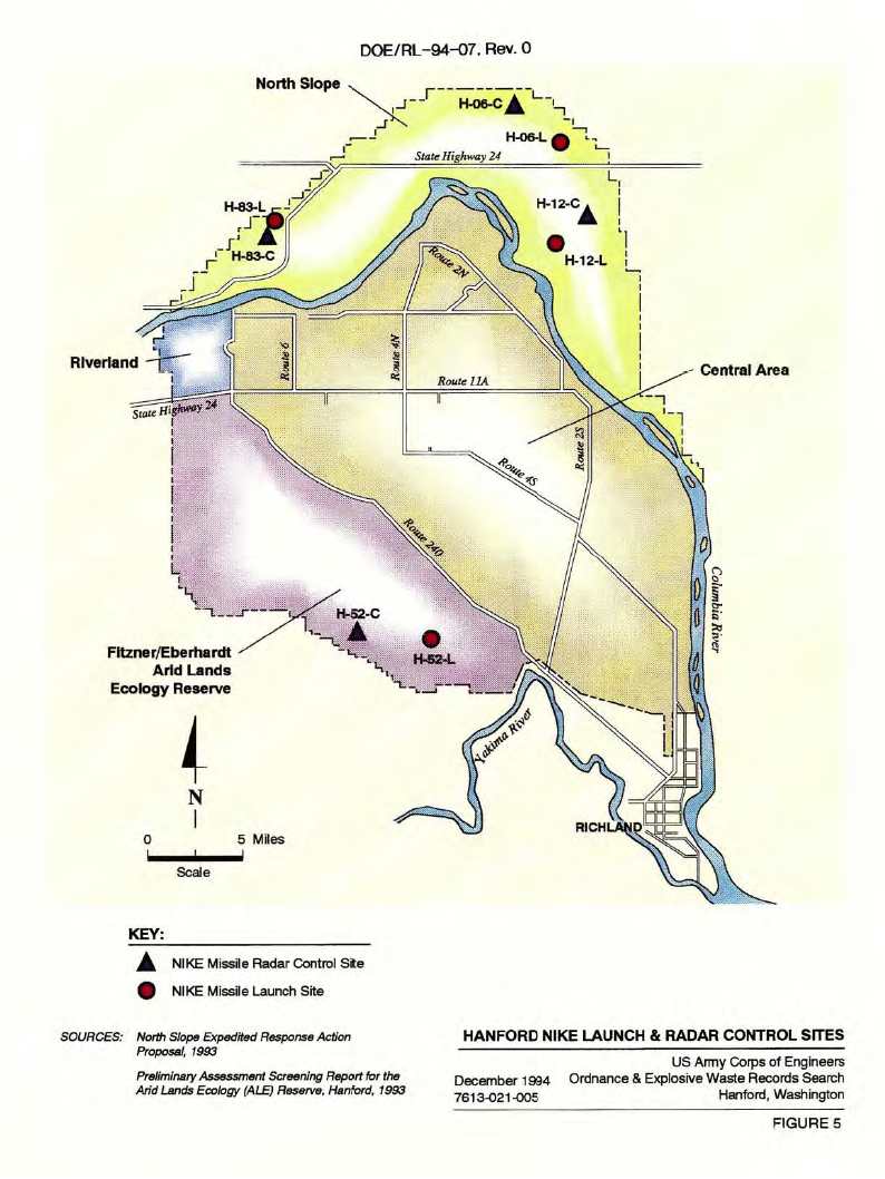
| H-06 | Saddle Mt. | [{Morgan, M}at the northeast corner of the {Hanford] reservation,
... north of WA 24.] C - 2 S Corfu, Saddle Mountain ((O)) L - 5 S Corfu, WA 24 ((O)) |
| H-12 | Othello | C - 14 SW Othello ((O))
L - 15 SW Othello, Grant/Franklin County Line ((O)) |
| H-52 | Rattlesnake Mt. | C - 11 WNW Benton City, Rattlesnake Mt. ((O)abandoned)
[{Jonasen, D} (April 2013) says the observatory is observing wind - lots there ;-)) ] [{Packard, D} is atop Rattlesnake mountain and now houses an observatory operated by Battelle Northwest.] [{Snowberg, P} The H 52 C control center at the top of Rattlesnake combined administrative, radar, and barracks functions in one building. Observatory - Rattlesnake mountain ] [(Murdock, S) GPS 46-23-43 119-35-45 ]
L - 10 NW Benton City ((O)abandoned)
|
| H-83 | Priest Rapids | [{Morgan, M}on the bluff above WA 24 across the bridge over the
Columbia. ] C - 8 E Desert Aire, N of WA 24 ((P) Saddle Mt. National Wildlife Refuge) L - 8 E Desert Aire, N of WA 24 ((P) Saddle Mt. National Wildlife Refuge) |
| . | For locations and views, fly in using Google Earth thanks to NikeSiteSearchers |
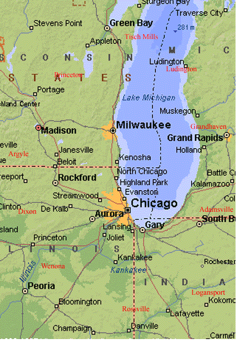
Map of Chicago-Milwaukee Radar Ring (88 K bytes) Cities in red [{Cocherell, H} text] Web Site Milwaukee Defense Area, by Neal Pritchett |
| Designation | General Location | Detailed Location (Current Status) |
| M-02 | Milwaukee [{Schafer, J}River Hills] | 2040 W Brown Deer
[{Usher, R} (Sept 2004) Have been watching the site over the years go from dismantling,to being reclaimed by nature for awhile and now a subdivison. Pops shack (pump house) may still be standing. I know the guard shacks and gates were standing for quite awhile after the remainder of the site had been demolished. Launcher area looks to be a subdivison now also. ] [{Schafer, J}Both radar and missile sites are gone and now an upper middle class subdivision, only a pump house remains on the north side of brown deer road within 1 mile west of interstate 43 on private land.] |
| M-20 | Milwaukee | 1200 Harbor Drive [{Schafer, J} Radar and crew quarters are now a senior center 1/4 mile north of college avenue on south lake shore drive.] [{Schafer, J}Launch site gone, was downtown on the lake front and is the Summerfest park just north of the Milwaukee river outlet.] |
| M-42 | Cudahy | 6100 S Lake [{Piland, D} Our current Google Earth location for Cudahy, WI - M-42 - Launch Area says it is approximate. I have taken a look at the 1963 Aerial image from Historical Aerials and located the real location. Historical Aerials returns the lat/long as: It seems that they used that area to expand the golf course.] |
| M-54 | Hales Corners/ Paynesville | 2400 W Ryan
C -
L -
A -
|
| M-64 | Muskego/ Prospect | C- College Ave.
[{Siegfried, William (Bill)} (Dec 2012) the IFC is located on Martin Dr. in between Ranch Dr. and East Dr. It is now the grounds of the I M Reynolds Machine Shop. It is a gated and secured area with many original buildings and perimeter fence. They were closed when we stopped by. This is not somewhere to walk through without permission. It appears from aerial photography that some remnants of the towers remain. A park next to the IFC opposite Ranch Dr. allows access to the rear fence line. We did not have time to walk up there to check it out but it looks like there may be a clear view of the rear area where the towers were. ] [{Rzeznik, J} (May 2006) The Control center is on Martin Road, and was a machine shop (as of late last year). Many of the original buildings are still there along with the fence--but heavily modified. [{Schafer, J}Radar and crew quarters are now a tool company on the north side of College Avenue 1/4 mile east of Small Road.
L - End of Arcadian Dr. off County Rd Y
|
| M-74 | Waukesha |
Community Park ... Abandoned Cold War Missile Site
and M-74 Nike Missile Site - Nov 16, 2022
- from Ron Plante
a web site from David J. Brouchoud - Dec 2017 [{Boggs,A} (Feb 2009) Web Site [{Page, T} (March 2008) "Ex-missile site may become a park" - (Web site gone) C - Davidson Road [{Siegfried, William (Bill)} (Dec 2012) The IFC area is now called Hillcrest Park. Two radar towers are still standing. One is fairly complete (no radar unit) and the other is just the frame. If they could safely be made into observation towers the view would be great. There are a couple buildings in current use and there is a plaque near the flag pole which tells a little of the sites history. This area is open to the public. While part of the perimeter fence still exists it is not complete and the entrance is not gated. ] [{Rzeznik, J} (May 2006) ... owned and maintained by the City of Waukesha--city received the parcels on October 30, 1972 under the Legacy of Parks program. Subsequently, an underground reservoir was put under the site. There is renewed interest in the site, and last I've heard from the mayor, the city was looking into having a Cold War museum established on the site along with refurbishing the two remaining buildings (mess hall and a radar building). Then again, for this to happen, the federal government would need to approve of it. ] [{Schafer, J}Radar/crew quarters are now Hillcrest Park on Davidson road and buildings are over half gone. GPS coordinates N43 00.176' W088 11.641']
L -
|
| M-86 | Lannon [Menomonee Falls] |
C - Lannon Rd (Menomonee Falls)
[{Siegfried, William (Bill)} (Dec 2012) gated and locked. All of the buildings look to be intact and in use. The radar tower site, located directly across the street, is also gated with a No Trespassing sign in the open entrance way. The fields surrounding both sides of the IFC are used as snowmobile trails with lots of activity today. ] [{Morgan, M} (Oct 2012) This is the IFC that's split by Lannon Rd (N<>S), north of W Main and W Good Hope. Buildings are contained in the extreme northeast corner of Monomonee Park, surprisingly complete but also rotting into the ground, roofs collapsing, etc. "Radar row" was on the east side of Lannon, guard shack still standing and the road to the site quickly disappears into undergrowth. Also, a couple of "no trespassing" signs so I didn't attempt to get around the gate and up to the radar locations. Both components have signs on their fencing indicating Milwaukee Telephone Company. From looking at recent aerial imagery, the line where the radars were located is still out there, along with some foundations, junk, etc. Didn't see any shadows indicating the presence of towers (43-09-48N/088-09-49W) [{Rzeznik, J} (May 2006) The Control Site was split by Lannon Road. Buildings on west side, radar on the right. The Buildings form the Park Offices for Menomonee County Park--the former barracks is used as a storage shed for mowers, etc., the Admin building's a shed, and the mess hall is a recreational building that can be rented out--my troop stayed there a couple years ago--really cool. Radar site is privately owned and gated. I did not see any structures on the site as of about two weeks ago. ] [{Harris, T} Jan 2006, Lon=-88.0856849 Lat=431691964 [{Schafer, J}Radar Site (east side Lannon Road) and is vacant and privately owned]
L -
|
| M-96 | Milwaukee | C - 4228 Silver Spring
L - 5010 Silver Spring
|
| MS-20 | Roberts | (about 25 miles E of St.Paul, 10 miles E Hudson,WI
[{Schilling, C} - May 2007 - I was not able to get into the site as the security has been updated and is active but from outside the gate I could see 3 tracking radar's on trailer's, a hipar and a lopar on site at the launch site. There is an anti aircraft gun outside the main gate. - April 2007 - MS-20 privately owned ( I know his son-inlaw ) pits and elevators still work and the control center is a mini storage now. Buildings (C) are in a state of disrepair. I have not seen the launch site but am told that every thing works. Even the security is still functional. There is still a Nike on site at the Control Center. I plan another trip to the location this week to inspect further. ]
C - (abandoned)
L - (abandoned)
A tale involving this Nike site location
|
Return to Home Page,
Return to Nike Location index
go to previous,
go to top,
go to next
If you have comments or suggestions, Send e-mail to Ed Thelen
Updated Dec, 2022