This
just came in from Bob
West at
Saint
Simons Island GA.
He passed Mr.
Kennedy's
work with researching Hawk ADA sites in Korea. So for those of you
who served a tour or two in Korea with a Hawk Battery, may want to
contact Mr.
Kennedy
with your knowledge of the site you served with.
The C7/2 site
near Namyang was C1/2 when I was there 1976 to 1977. So you can see
how tough this research can be. Also you can link to the map they
have at -
http://koreaatourofduty.us/Installations68.html
and see how hard it is for them to work with
it.
Trapper
~~~~~~~~~~~~~~~~~~~~~~~~~~~~~~~~~~~~~~~~~~~~~~~~~~~~~~~~~~~~~~~~~~~~~~
38th
Air Defense Brigade (HAWK) Battery Locations - Korea - 1960's
William
Kennedy
hawkvets@...
Wrote:
Sorry
to take so long to answer, I have been in the hospital for the past
two months.
There
would be two cord. for each site. The admin site and the TAC site
would be different. You would spend so many days on the admin site
and so many on the TAC site depending on your site and the distance
between them. Your on time and off time. I have never seen the TAC
and site numbers being different. I know there were TAC sites 1
through 5 but I don't think they belonged to us.
Bob
West
Wrote:
That
would be a damn good question to put out on the forum! What does the
TAC 5,
Site 44 mean in the case of B-6-44 HAWK & likewise for TAC
5, Site
33 for D-7-2 HAWK? The numbers cover 1-5.
Ken
Legacy
I
have your site listed as TAC 5 Site 44. I have no clue as to what the
numbers 1 through 5 means on the listings I have.
I
have D-7/2 as TAC 5 Site 33 (Nov 71).
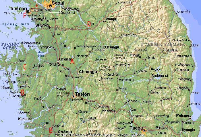
http://koreaatourofduty.us/Installations68.html
Bottom
of page, Suwon map section. Looks like 1 is admin and the other the
site.
Click
for larger view. Sorry, that's the best it looks. Even the original
map can't be read any better.
Something
I never noticed before. A lot of the site listings have 2
coordinates. Maybe 1 for admin and 1 for actual site. I may have to
look into that further.
Ken
From:
Bob
West
A
couple of years ago, at the suggestion of an alumni friend from
Battery B-6-44, I started a project of accurately locating all of the
U.S. Army HAWK batterys in S. Korea & associated administration
areas of that period. I used "Google Earth" plus old maps,
personal accounts & flight charts. I value most highly the
wonderful people with whom I have connected during this time from the
Army, Air Force, Koreans, both here & abroad, & computer
wizards. They were such great help. It's been quite an education for
me & it's kept me off the streets for a right good while too!
I
was fortunate to travel (TDY) a lot when I was in Korea during 1968 -
1970, which greatly helped me with the geography. Many folks didn't
really have much of an idea where they were over there and didn't
have too much chance to move around, except on truck runs, so I am
attempting to help with that. I notice that as more people retire
they become more interested in these things, as I did. I just wanted
to pass along some of the things that I learned.
All
locations are given in WGS-84 format (current GPS standards).
Comparing this against old charts & maps, that you might have,
will reveal some error but this is the way of today's navigational
standards. Using my information should enable one to see where his
old missile site and barracks were or are located. Some areas haven't
come into clear focus yet but will in time. I'm trying to keep up
with the changes. If you ever get a chance to travel overseas, back
to the "Land of the Morning Calm", you will be able to put
these numbers into your own GPS and actually get to your old unit
location (if desired!)! I have included a number of other locations,
such as "Villes", that I have come across (& things
found while looking for other things).
Any
corrections or additions are always
appreciated. I know
that I have made some mistakes & omissions so please feel free to
contribute.
This
information is for anybody who finds it interesting. I also intend to
forward it to the Korean War Project, Hawkvets, Tour of Duty, Agent
Orange folks, etc. Distribution, advice and feedback is encouraged.
Bob
West - 23R20, B-6-44 Kunsan AB 1968, 38th Bde AMU & 8th Army AMU
---------------------------------------------------------------------------------
Headquarters
Battery 1/2 Admin.:
There is already confusion on this one as I understand that there
have been two admins. (also 7/2) there at 37° 27.0'N / 126°
54.0'E or near Siheung, app 10 mi. S of Seoul. This is a very
developed area now.
A-1-2
Admin. (A-7-2 Admin. also): I have an Admin. at 37° 4.354'N /
127° 9.674'E and this is confirmed
by "Google". Nearby is Songun-ni.
A-1-2
Tac site (A-7-2 Tac also): 70's 37° 4.588'N / 127° 10.467'E
confirmed
B-1-2 Admin.: There is more confusion here at 37° 21.855'N / 126°
46.547'E. This conflicts with B-7-2, which I understand was here
first. "Google" confirms
this and states that it has been returned to the Koreans. I can't
identify the nearest village name but notes tell me that it is
"Wonha-Ri". There is lots of development toward the Yellow
Sea.
B-1-2 Tac. site 42, Another site # change: B-7-2 was here first and
replaced by B-1-2, I understand. Pos. is 37° 22.057'N / 126°
46.879'E. confirmed
C-1-2
Admin.: 37° 11.825'N / 126° 50.241'E, 1970's confirmed
C-1-2
Tac. site: 37° 12.326'E / 126° 50.882'E, 1970's confirmed
D-1-2
Admin.: Appears to be at same location as tac. site
D-1-2
Tac. site: 37° 28.270'N / 127° 0.543'E confirmed
by Google
Headquarters
Battery 7/2 Admin.:
I've found two locations - both very industrialized and close
together at 37° 26.251'N / 126° 53.222'E and 37° 27.058'N
/ 126° 54.026'E on opposite sides of the canal - help me
somebody! I show Songon-Ni as the nearest village but it has probably
been covered by growth. Siheung is nearby.
|
July 10, 2018, James Sedlock < sagebrush923 @ gmail . com > e-mailed " ... from Bob West and in the coordinate information is a plea for help with two possible coordinates for HQ Admin 7/2. Checking the coordinates with Google Earth, I wish to confirm that the second set (37� 27.058'N / 126� 54.026'E) is the correct one for HQ Admin. I recognize the position of the road to the East, and the railroad tracks immediately to the West of the camp. I took pictures of steam engines on those tracks.
|
A-7-2
Admin.: 37° 4.354'N / 127° 9.674'E, in 60's, see B-1-2,
became A-1-2, in 70's confirmed.
Songon-Ni was the nearest village and is at 37° 4.434'N / 127°
9.432'E
A-7-2
Tac. site: 37° 4.572'N / 127° 10.467'E, confirmed
B-7-2
Admin.: 37° 21.832'N / 126° 46.532'E, became B-1-2 in 70's
confirmed
B-7-2
Tac. site 41: 37° 22.057'N / 126° 46.879'E, became B-1-2 in
70's confirmed,
nearest village was Soreapo-Gu?
C-7-2
Admin.: 37° 11.798'N / 126° 50.156'E, confirmed,
nearest village is Namyang at 37° 12.538'N / 126° 49.121'E,
from the 60's
C-7-2
Tac. site: 37° 12.291'N / 126° 50.902'E, from the 60's,
confirmed
D-7-2
Admin.: from
the 60's,
unable to locate
D-7-2 Tac. site: unsure location of 37° 26.545'N / 126° 57.104'E
This was an Army coordinate and shows nothing there. Gwachon shows as
the nearest village at 37° 25.759'N / 126° 59.258'E but it's
a big place now! Highest hill in area is at 37° 26.723'N / 126°
57.818'E at 2000 ft., help!
David Luedtke, SP4, 22J20 D Battery 7/2 - pineapple @ mac . com - says:
D-7-2 was a Hawk site. I think this might be it. I was only there for about 8 months,
47 years ago, but it looks right to me.
Open the .kmz file with Google Earth.
|
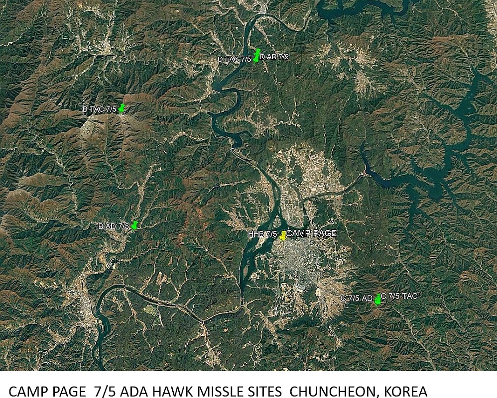
Headquarters
Battery 7/5 admin.
: app. location is 37° 52.963'N / 127° 43.344'E at Camp Page,
Help somebody, it's a big place! Nearest "village" is
Chuncheon. It surrounds Camp Page.
A-7-5
admin.: unable
to locate
[from Mike Teister ---mjteister@ yahoo.com, October 24, 2016
"The A-7-5 admin. Area was on the north-west end of Camp Kaiser which closed in 1970.
The Camp was turned over to the village of Un-Chonri which is now some other name that
I don't know. The camp and now the village is just off route 43 at the southern part
of the Chorwon Valley. "]
A-7-5
Tac.: unable
to locate
[from Mike Teister ---mjteister@ yahoo.com, October 24, 2016 " The Tac site was 3 miles
south off a western access road from route 43. It was up on a mountain around 2000 ft. It overlooked the route 43 and had a north view of the Chorwon Valley." ]
B-7-5
Admin.: 37° 53.603'N / 127° 33.518'E, closest village is
Hwaak-Ni (sp) or Gapyeong at 37° 49.916'N / 127° 30.572'E ?
B-7-5
Tac. site: 38° 0.063'N / 127° 32.416'E, confirmed,
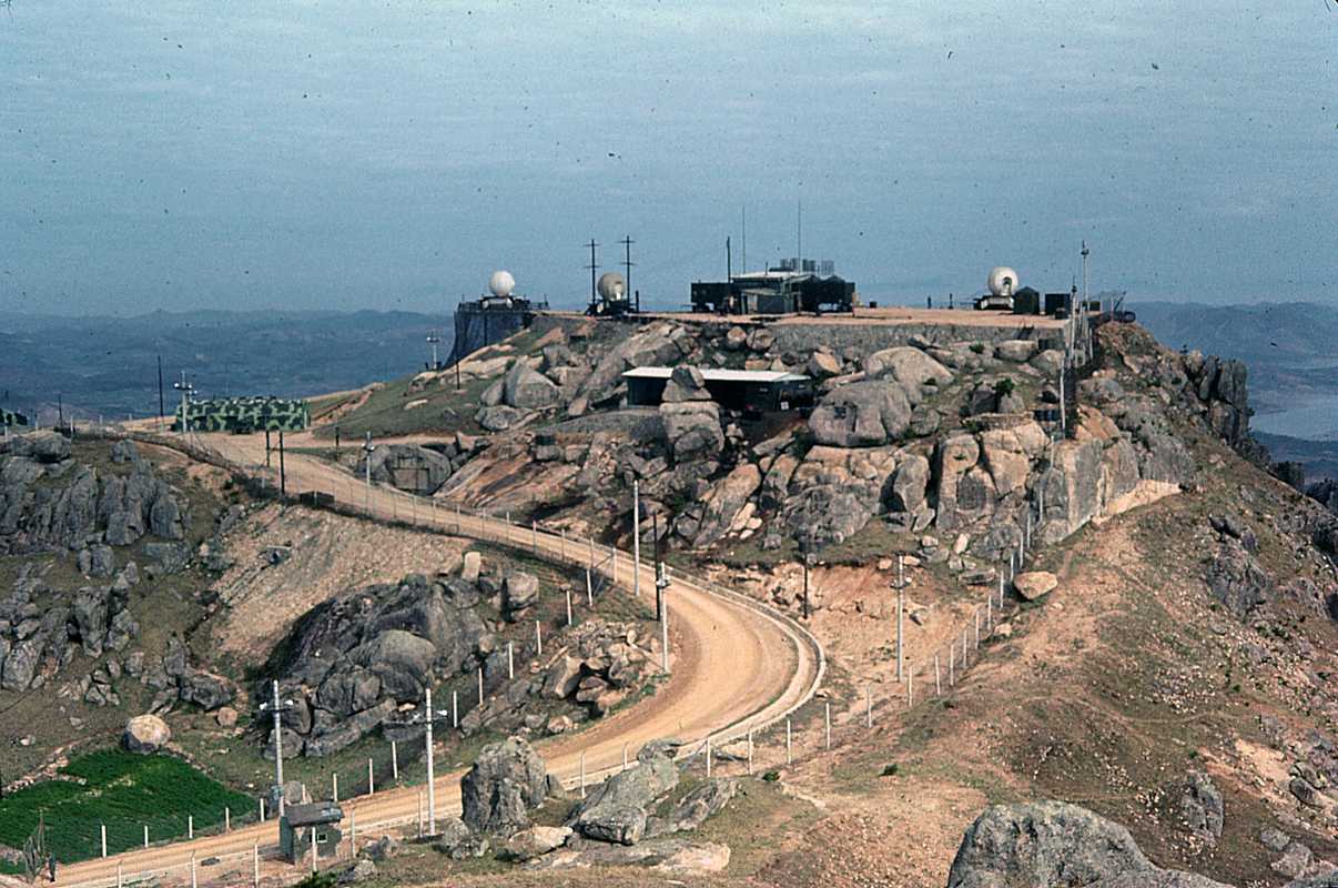
Mae
Bong mountain - highest HAWK site in the world (4645 ft.)!
C-7-5
Admin.: 37° 49.718'N / 127° 47.145'E, confirmed,
Chuncheon - nearest "village" that I see.
C-7-5
Tac. site 40: 37° 49.831'N / 127° 48.992'E, confirmed,
I have a (nearby) village named Hwacheon that's actually closer to
D-7-5. See following.
D-7-5
Admin.: 38° 3.345'N / 127° 41.779'E This position only shows
a big scrape mark although I received good verbal information on this
one. Hwacheon is close by on the river at 38° 6.351'N / 127°
42.485'E. confirmed
D-7-5
Tac. site: 38° 3.006'N / 127° 41.683'E Strange looking site.
confirmed
Headquarters
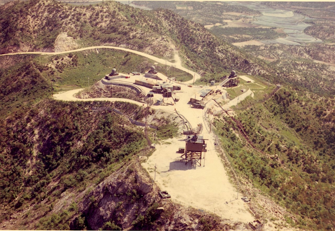
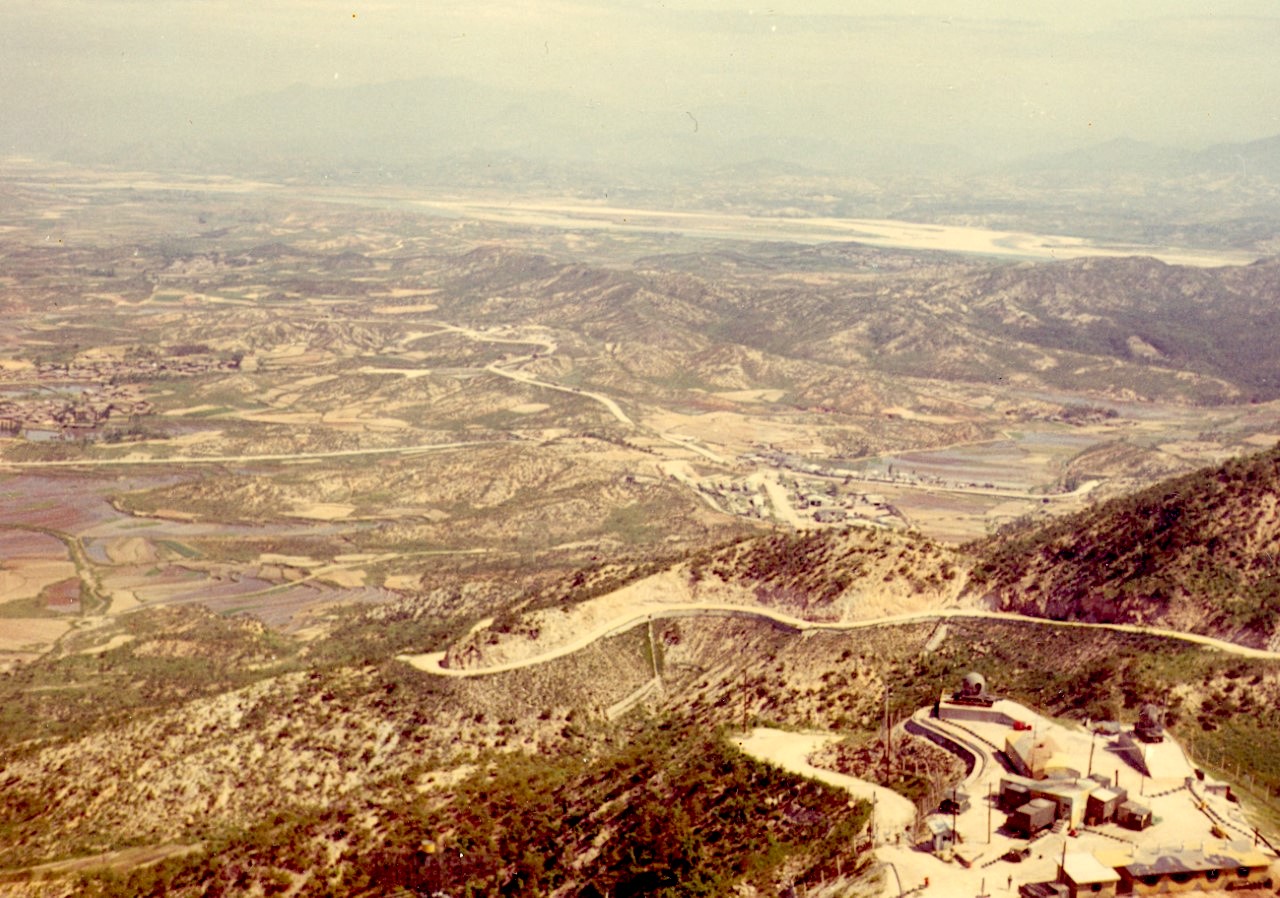
Battery 6/44 Admin. "Reno Hill":
36° 31.949'N / 126° 37.490'E, confirmed,
very little to recognize now, nearest villages are Hongseong &
Gwangcheon - both app. 5 mi. N & S of unit on main road.
Reno
Hill Tac. site (Radar only):
36° 31.820'N / 126° 36.355'E, confirmed
by survey & aerial photographs,
very little to recognize now
A-6-44
Admin.: 36° 57.046'N / 126° 57.453'E , I understand that this
was D-7-2 previously. I'm told that the nearest village was
Tok-ma-Ni, but it is Deokmok-Ri now.
A-6-44
Tac. site: 36° 56.619'N / 126° 57.751'E, confirmed,
Old D-7-2 I'm told. Nearest village is Anjung-Ni.
B-6-44
Admin.: 35° 54.753'N / 126° 37.081'E on Kunsan AB, confirmed,
nearest city is Kunsan
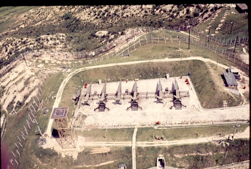
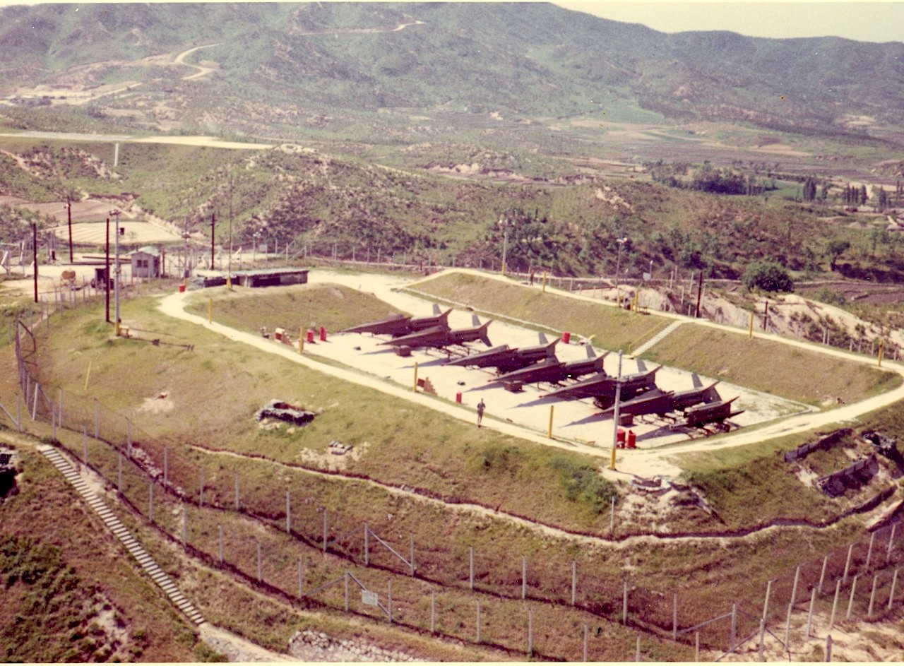
B-6-44
Tac. site 44: 35° 54.214'N / 126° 40.707'E confirmed,
nearest village is Okku at base of hill. My site!
C-6-44
Admin.: 36° 56.74'N / 126° 34.324'E confirmed,
village nearby is Dangjinpo-Ri at 36° 53.61'N / 126° 37.70'E
& Janghang-Ri at 36° 56.809'N / 126° 34.898'E
C-6-44
Tac. site: 36° 56.579'N / 126° 34.124'E confirmed
D-6-44
Admin.: 36° 8.363'N / 126° 36386'E, confirmed,
nearest village is Piin at 36° 8.316'N / 126° 36.234'E
D-6-44
Tac. site: 36° 9.208'N / 126° 33.769'E, confirmed
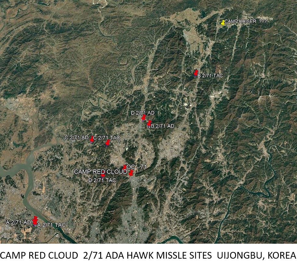
Headquarters
Battery 2/71 Admin.:
I have Camp Richmond at app. 37° 31.775'N / 126° 48.693'E as
a "non-firing position". It is south of the SE end of Kimpo
ramp. I also have a HHQ/DSP
2/71
at Camp Red Cloud (Oijongbu City) at 37° 45.130'N / 127°
1.827'E, confirmed.
There was a search radar (at 37° 45.791'N / 127° 0.164'E)
that seldom worked, I heard, confirmed.
This is confusing.
A-2-71
Admin.: 37° 37.417'N / 126° 42.404'E or off the NW end of
Kimpo ramp, surrounded by Gimpo City, confirmed
(slight
change thanks to 1Lt. Steven Smith - Ex TCO from the day)
A-2-71
Tac. site 42: 37° 36.997'N / 126° 42.560'E, confirmed
B-2-71
Admin.: 37° 54.035'N / 127° 5.059'E Nearest "ville"
is Tokari at 37° 53.742'N / 127° 5.100'E, just S of Camp
Hovey. I'd love to find "Mickey Mouse Corners". Pobwon-Ni
is located at app. 37° 50.944'N / 126° 52.381'E. I understand
that this group was located in five different places over the years.
confirmed
B-2-71
Tac. site 32A: 38° 3.787'N / 127° 15.367'E, SW of Camp Kaiser
at one time, other site is an area NE of C-2-71
C-2-71
Admin.: This is a tedious one as things have changed. I have B &
C admins. combined
at 37° 51.148'N / 126° 52.714'E, Camp Irwin. I also have a
position of C-2-71 at 37° 51.271'N / 126° 52.695'E, Camp
Warner - C admin. confirmed
C-2-71
Tac. site 36: 37° 50.501'N / 126° 56.154'E, still not a good
picture, confirmed
D-2-71
Admin.: 37° 55.117'N / 127° 3.757'E confirmed.
Another location was app. 5 mi. W of Camp Red Cloud (1972).
D-2-71
Tac. site 34: unclear exposure but I am advised that it is 37°
44.970'N / 126° 55.838'E. It is app. 6 mi. W of Uijongbu.
confirmed
38th
Brigade Headquarters at Osan AB:
37° 4.844'N / 127° 2.155'E confirmed.
The nearest Cities are Songtan and Osan
AADCAP
1(S), site 91?:
unclear photography but I'm advised that it is near 36° 55.705'N
/ 126° 26.442'E
OP
CEN 71?:
Hill 468 at HHB 2/71, I'm unsure of the terminology. Is this the
erratic search radar SW of Camp Red Cloud at 37° 45.791'N / 127°
0.164'E?
AADCAP
2(N), site 92?:
37° 29.866'N / 126° 32.266'E on Walmi-Do, just NE of Inchon
International Airport, I got this by word of mouth - any help is
appreciated.
Sea
Range, site 2, Camp Holiday:
36° 17.988'N / 126° 31.440'E, The location is confirmed
from flight charts, eye witnesses and photographs. Nice place to
visit.
This
finishes up my report but for those that are interested, I am
throwing in a few more locations that may be of some value to those
who might have been there and would like to see what their old
location
looks like today.
HERC
Tac site E-4-44: 35° 46.869'N / 126° 55.880'E, unclear image
but this will be improved with time. The site was near Gimje
Yongsan
Bus Station: 37° 32.173'N / 126° 58.769'E, confirmed,
same
old place & the police station is still next door.
YDNCOOM
(Yongsan District Non-Commisioned Officers Open Mess) "The
Country Club of the Orient": 37° 31.950'N / 126°59.225'E,
confirmed
Panmun-jom:
37° 57.345'N / 126° 40.639'E, confirmed
Freedom
Bridge: 37° 53.440'N / 126° 43.985'E, confirmed
U.S.S.
Pueblo, in Pyongyang now, no longer in Wonson: 38° 59.457'N /
125° 43.530'E, confirmed
Paris
Highpoint site (for the AF guys): 36° 47.787'N / 127°
12.476'E
I'd
also like to locate the Ascom Reception Center, if anyone is up on
that one.
| 