Return to Home Page,
Return to Nike Location index
go to previous,
go to top,
go to next
| . | For locations and views, fly in using Google Earth thanks to NikeSiteSearchers |
A Web Site covering the Cleveland area |
| Designation | General Location | Detailed Location (Current Status) |
| CD-27DC 88th Arty Gp | Wilmington | 4 SE, SR 730 and Osborne ((I)Nike Center Town & Country School/Orion Industries) |
| CD-27 | Wilmington |
C - 4 SE, SR 730 and Osborne ((I)Nike Center Town & Country School/Orion
Industries)
[(Moats, R) (May 2013) Site 27 IFC was turned over Clinton County Board of Education. ] [(Murdock, S) GPS 39-24-31, 83-53-43, Topozone (Combined view) ] [(Jordan, J) (November 2002) .. now a Clinton County school for handicap kids ]
L - 4 SE, Osborne Rd ((I) private owner)
|
| CD-46 | Felicity |
C - 3 W Felicity, S of OH 156 (OHArNG: Company C, 216th Engineer Bn)
[(Murdock, S) GPS 38-51-07, 84-09-20, ]
L - 3.5 W Felicity, S of OH 156 (Industrial park)
|
| CD-78 | Oxford | [(Page, T)
Office of Federal Facilities Oversight
C - 3 NW Oxford, Todd Rd N of US 27 (USAR Center) [{Jordan, J} (March 23, 2003) I was by there on 3-23-03 to take a look for the first time it was great. I had a big surprise. There were some transport trucks, tankers, a 6 m1a abrams sitting there looking ready to go. I couldnt get too close I didnt want to get detained. Out of all the ones I have seen in the Cincinnati area this one looks like it could be used at any time. I wonder why those tanks were sitting there? ] [{Piland, D} "... closed gate about 30 yards from the road. It looks like all they would have to do is move the systems back and it would be ready to go. All the way to the lightning rods on each of the radar towers." ] [(Murdock, S) GPS 39-33-02, 84-46-21, ]
L - 4 NW Oxford, Taylor Rd N of US 27
|
| CL-02 | Bratenahl | web page
C - 8925 Lakeshore ((O) state waterfront park)
L - 555 E 88th St. ((O)US Navy Finance Center)
|
| CL-11 | Painsville | web page
C - 505 Blackhawk (Lubizoil Corporation; storage yard)
L - (County Engineer's office)
|
| CL-13 | Willowick, Lake Co. | web page,
local history
spotted by Thomas Page
C - 30100 Arnold Rd ((P)Robert Maury Park) [(Vaughn, T) (June, 2000) The original fence is still in place and the [city] park fills the whole area of what was the IFC. The only building left is a small pump house.]
L - 33525 Curtis Rd ((P) Willoughby-Eastlake School District;
School bus terminal and storage area,
J F Kennedy Senior Center
|
| CL-34DC | Warrensville/ | web page
|
| CL-34 | Warrensville/
Highland Hills | web page
[(Vaughn, T) (June, 2000) Warrensville had a name change and is now Highland Hills.]
C - S of OH 87 ((P) USAR Center, 319th Qm Bn, 444th Qm Co.)
L - 3978 Richmond Rd ((O) abandoned )
|
| CL-48 | Garfield Heights | web page
C - 5640 Briarcliff (Garfield Heights Board of Education) [(Vaughn, T) (June, 2000) The IFC is complete, though I didn't see a basketball court. This site had the barracks and admin area in the IFC. It's used by the school district for their offices. It's in very nice shape with the original flag pole still in use. The school district business manager was very friendly and showed me the 1955 dated "as builts" plans for the site that the Army gave them when they were given the site.]
L - 733 Stone Rd
|
| CL-59 | Parma/ Midpark Station | web page
C - 7300 York (Nathan Hale Park) [(Vaughn, T) (June, 2000) ... the only signs of the IFC was a park sign that pointed the way to "Nike Site Building" which was a heavily modified Nike era building being used for maintenance.]
L - Pleasant Valley Rd (Cuyahoga Community College, Western Campus)
|
| CL-67 | Lakefront Airport | web page
C - 4200 S Marginal ((P)City of Cleveland; J L Stamps District Service Center) [(Piland, D) (June, 2010) Lat 41.5210, Long -81.6660 [(Vaughn, T) (June, 2000) I could not find the IFC. The address listed is a city plant of some type.]
L - Airport ((O) Cleveland Lakefront Airport; runway)
[(Bateman, T) (May, 2007) I have not found anything that would indicate precisely where CL-67 IFC is (FUDS GIS website does not show an entry for the site and I was not involved in your previous discussions) but I was provided with two photos that show CL-67L under construction on the site of what is now Runway 6L at Burke Lakefront Airport. They can be found at http://nikehercules.tripod.com/cl-67.html. [(Page, T) (July, 2003) (After many e-mails between 5 or 6 people trying to locate/identify launcher area of CL-02.) It appears that CL-02 is now correct. However, CL-67 apparently is not. It appears that your CL-67L text is actually describing CL-02L! And, that exactly describes the CL-02L site that Gale Maxey just nailed down. Mark Morgan's description of CL-67L is that it indeed was at the airport. However, I do not think that one has actually been verified ... or, has it, Mark? Thanks ] (Adventure ;-) [(Vaughn, T) (June, 2000) The launch area is not on or in the airport nor now a runway. It is on the north side of I-90, east of the airport. Use the Martin Luther King exit to get to it. ... I was on the interstate and saw what looked like Nike buildings in a park. What I found was the barracks and admin area. It wasn't a park. They were behind a fence in a high security type setup. At first I thought it was a prison. There was a state ranger station next door and I asked them where the missile magazines where. They said they were inside the secure area and I'd have to go to the gate to get access. I did that and pressed the button to talk to someone and they said no one was admitted in the evening and I'd have to talk to (X) for permission to see the magazines. I knew I was near them because right inside the gate was an assembly building. The next morning I went to the gate and said I was there to see (X) and take pictures. They let me in and (X) meet me and said I'd have to get permission of the commanding officer to take pictures. Well, I already seen what I had come to see. The 3 magazines were still in place in the parking lot. They had fences around them. I wasn't able to get pictures because the (X) met me as I entered. (X) took me to the CO's office but he wasn't in. His secretary had a fit that I was let in. Wanted to know how I got in, who let me in etc. Told me I had to leave immediately and write for permission. I left her office but (X) who brought me there was gone so I returned to the parking lot by myself. I then got all the pictures of the magazines and buildings I wanted. Still don't know what that place really was. The offices were in a large bunker type building with no signs on it. The CO was a full bird Col. As I walked through that building I saw signs that said something about Army Material Command. ] |
| CL-69 | Lordstown Military Res/Fairview Park | web page
A fun question from David
C - Westwood Ave ((O)park and housing)
L - 21700 Westwood Ave ((O) Tri-City Park)
|
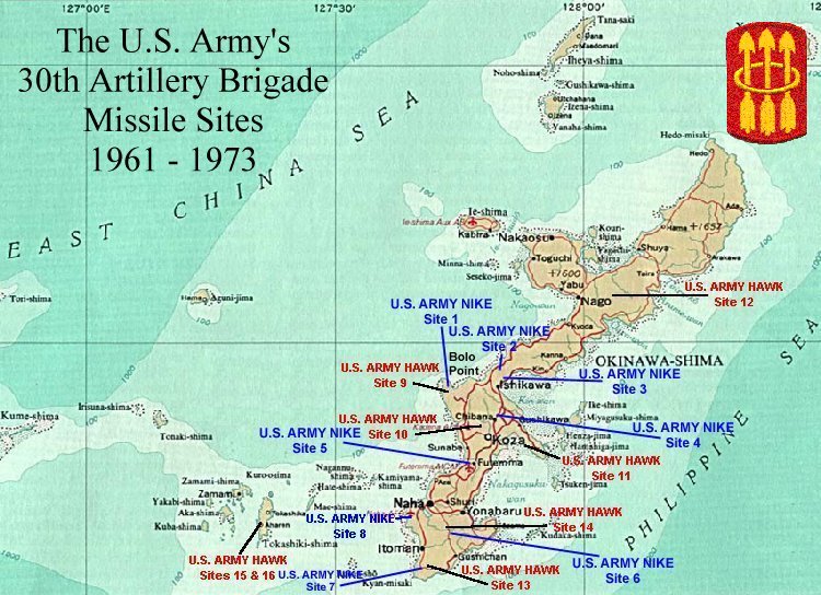
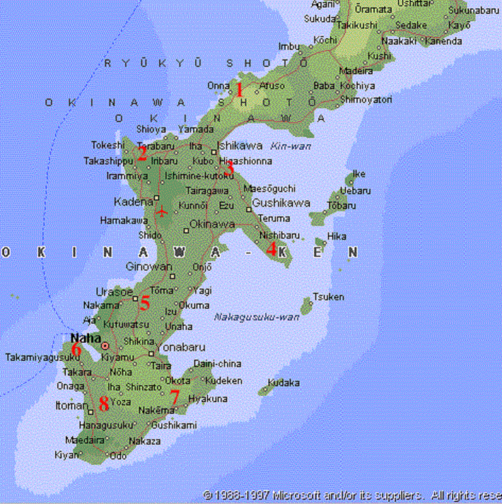
| . | The struggle to specify the position of Korean (and Okinawan) Nike sites
was long and confused - what I have listed is at best a compromise that seemed to satisfy most people.
| Designation
| General Location
| Detailed Location (Current Status) [See location maps and comments below] | 30th Artillery Brigade (AD)
| Sukran
| Sukiran [(Hintz, L) (Aug. 2003) South of Kadena, down Highway 1 ]
| [(Pettinari, John) (May 2010) ] ?2/61?
| - - Alpha Site # 1
| [(Sinclair, A) (May 2002)
Sites 1-4 were on the north end of the island. Sites 9-16 were Hawk sites.
I was a Western Electric Tech Rep supporting the 1/65 from August 1966 to
October 1968. All of the sites at that time were Improved Nike Hercules.] | - - Bravo | Site # 2, ?@ Tokeshi? ?Ishikawa Daki, ?
| [(Bailey, P) (April 2008) Google Earth has recently updated parts of Okinawa
| The site 2 IFC area ruins are now clearly visible on the top of Ishikawa Dake The buildings are still standing. The launching area which is to the N/E appears to have been developed for other use. [(Bailey, P) (October 2007) Okinawa Site 2 Was on the mountain top just above Ishikawa. Also known as Ishikawa Daki. I believe "Daki" means mountain. It was one of two HIPAR sites the other was Site 6 - - Charlie | Site # 3,
| [(Pendell, Bob) (November 2007) Site 3 charlie battery was next to Isikawa
above Moon bay. Hope this will bring that up to date.
| - - Delta | Site , 4
| White Beach [Martin, Roy (Aug 2018)
I was there in 1969. The site is clearly identifiable via Google Earth at coordinates:
| 26 18’ 31” N 127 53’ 58” E The launch pad (and the entire site for that matter) has obviously been repurposed, but then it’s been nearly 50 years! 1st Bn, 65th Aty
| - - Alpha Site # 5?
| [(Sinclair, A) (May 2002)
Site 5 was on MCAF, the Marine Corp Air Facility in Futema. ] | - - Bravo | site #6
|
[(Rusher, J) (Nov 2012)
Actual location on map is near Kudeken as far south and east as you can get high on cliff
with the Pacific on one side and Nakagusuku Bay on the other.]
[(Pettinari, John) (May 2010) Battery B -B/8/3
We were located close to Chinen in the south,high on a hill overlooking the sea.]
| [(Sinclair, A) (May 2002) Site 6 was in Chinen, right next to the Hawk battery. They did have a HIPAR radar. The HIPAR was built by GE and was a high power acquistion radar. The standard acquistion radar with Hercules and Improved Hercules was call the LOPAR, or Low Power Acquistion Radar. It was built by Western Electric ] see note by Stanley Yamada see First grade childhood experience by Christopher Hoke - - Charlie | site #7
| [(Sinclair, A) (May 2002)
Site 7 was at Yozadaki but I don't remember a HIPAR radar at that site. It
was the headquarters for the 1st Missile, 65th Art then [1966-1968]. ] | - - Delta
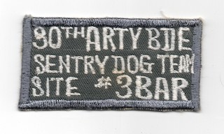
| accident site #8 - protected Naha Air Force Base
| [(Brown, S) (Mar 2011) The fire control area was located
on the West side of the Naha flight line along with the mess hall , barracks and the
Battery Commander. The launcher area was tucked between the East side of the flight line
and the South China Sea, barracks, missiles, assembly and tech buildings and the
4 k9 kennels. Those of us on the launcher side commuted to the mess hall via deuce
and a half, three times a day. ]
| [(Sinclair, A) (May 2002) Site 8 was on Naha Air Force base and shared a AAR (Auxillary Acquistion Radar, actually built by Raytheon) with the ADCAP that was there also. ] |
From Tom Madracki, September 2005
| Nice Nike site! I was Hawk, but at least on Okinawa, they were related. Some of the Okinawa maps are either completely wrong or incomplete. I was at Hawk site 9, next to Nike site 1. Here's my map. [Actually his web site :-)) ] |
|
From Roger Mills, August 2005
|
I served on site 2 a, the fire control area. It is shown as site 1.
Site 1 was also HQ and was located at Yomatan. Site 2 was located
where site one is shown. I was there from 1967 to 1970.
|
From John Purves
| "There are at least five former Nike-Hawk sites located south of Naha City on pieces of land long since returned to Okinawa. North of Naha, there are a good few more. By far the largest number of missile sites were purpose-built facilities located outside of the larger Army and Marine facilities (most of which still exist)." |
|
| Map base from Microsoft Encarta Virtual Globe 1998, Nike site locations from Japanese book published by the TAIHEI SHUPPANSHA (literally "Peace Publishing Co".) in July of 1968. It was edited by NAKANO Yoshio and entitled "Okinawa Mondai o Kangaeru" (Lit: "Considering the Okinawa Problem"). Map from book forwarded by From John Purves |
|
Correction offered by Doyle Piland
| By the way, if you were talking to an American who served with Nike in Okinawa with Nike, the site numbers listed on the above web site map would be different. Site 6 was where they show site 7, site 7 was where they show site 8, and site 8 was where they show site 6. |
Comments by Doyle Piland
|
The radar areas would have something different that any other Nike radar
sites in the world. The radars were mounted on towers or platforms like
many others but had "clam-shell" type covers which could be raised during
typhoons to protect them. For this reason, the towers/platforms were
pretty sturdy. You can find pictures of radar areas at
http://www.nikeordnance.com/
and at several of the sites linked
at the bottom of that page.
Bolo Point was near Site-1, which was "A" Battery of the ??/61st ADA. There were two launchers moved to Bolo Point (from maintenance spares or floats I think) and set up for the Nike Annual Service Practice (ASP). Bolo Point was what seems like 1.5 to 2 miles west/southwest of the Alpha Battery launcher area. The units doing their ASP used the Alpha Assembly & Test building for their buildup. The IFC crew used the Alpha IFC for check out and the actual firing. Bolo Point was at the very western tip of the Yomatan Peninsula near the center of Okinawa. I was on Okinawa for four years and I think I saw all 32 that were fired during those 4 years. |
ROGER C HUBER reports that these had underground magazines (similar the those in the U.S.).
Thomas H. Brown offered
| I was right in the middle of things as Security (S2),Operations (S3), and Supply
(S4) officer for the 8th Bn., 3rd Arty. As an explanation of why a Warrant Officer
would have such duties, there were only four officers assigned to battalion;
The commander (LTC), the executive officer (MAJ), personnel officer (S1) (CAPT)
and everything else on a W4. Brigade was responsible for all inspections and evaluations.
My duty was to keep the Commander out of trouble. It truly was a rewarding experience.
The enclosed article appeared on the Coral Courier, the weekly paper published by the U.S. Army Base Command, Okinawa. It was published in Vol.2, No. 22 dated June 1, 1973. |
|
The 30th Air Defense Artillery Brigade, located on Okinawa will cease operations and be placed on inactive status this month. The brigade, which presently is composed of two battalions, the 8th Battalion, 1st Air Defense Artillery (Hawk) and the 8th Battalion, 3rd Air Defense Artillery (Nike Hercules); the Headquarters Battery and the 44th Ordinance Company (Guided Missile) (General Support), is being phased out as a result of the reversion of the Ryukyu Islands from United States control to the control of the Japanese Government which took place last year. ... unit histories ... In 1959 the Army’s 97th Group converted to the highly capable Nike-Hercules air defense missiles and on June 24, 1960 was redesignated the 30th Artillery Brigade (Air Defense). ... In 1961 the 30th Brigade was brought to four-battalion strength with the arrival of battalions of the 1st and 3rd Artilleries armed with the deadly Hawk air defense missile to provide protection against low altitude aircraft. On June 6, 1961 the 30th Artillery Brigade (AD) became the first Allied unit to fire a Nike-Hercules missile outside CONUS. ... On November 21, 1969, in a joint communiqué, U.S. President Richard M. Nixon and Japanese Prime Minister Eisaku Sato announced that the Government of Japan and the Government of the United States of America should enter immediately into negotiations for the reversion of the Ryukyu Islands to Japan. After extensive planning, the reversion of the Ryukyu Islands took place on March 15, 1972, terminating over 25 years of United States administration.
Included in the reversion agreements was an arrangement that Japan would assume the responsibility for the air, ground and maritime defense of the Islands not later than July 1, 1973. The Government of Japan agreed to deploy A Nike group (3 batteries), a Hawk group (4 batteries) and appropriate supporting troops to Okinawa to carry on the surface-to-air missile role in the Air Defense Mission. Additionally the Government of Japan agreed to buy the U.S. equipment presently located on site. A Surface-to-Air Missile Transfer Plan was jointly prepared by U.S. Army, Japan Air Self Defense Force (JASDF) and Japan Ground Self Defense Force (JGSDF) planners. The Nike missile systems were transferred to the JASDF and the Hawk missile system to the JGSDF. In accordance with the Transfer Plan, on-site orientation and familiarization took place on Nike sites, with 30th ADA Brigade and JASDF advance party personnel working and living together on site. Brigade personnel manned the sites until transfer was complete. When all facets of the transfer are complete, one of the significant phases of Okinawa Reversion will be finalized. The Brigade is proud to have been a part of such an historic event. By the end of this month, the 30th Air Defense Artillery Brigade will officially cease to exist as an active unit. ... |
From Mike Murray
|
Site 7 was located on the very south tip of Okinawa. The area was called
Yozadaki and it was a mountain area. Site 7 was the headquarters location
of the 65th Arty which was part of the 30th Arty Brigade.
The IFC area had a large HYPAR system and we had a swimming pool, tennis
courts, baseball field with night lights and cement blocks dugouts. Several
generator buildings, 3-van building, EM club,
BOQ, Mess Hall, Barracks, Admin buildings and a Underground Communication
Center. The Launching area was on the road that led to Suicide Cliffs
Monument. The address of site 7 was
Also there was Hawk missile site next to us and it was known as site 14. It two was part of the 30th Arty Brigade. If I remember site 6 was located at Naha Air Base which was a couple miles south of Naha. I remember site 1 was located North about 20 miles of Naha. I was at site 7 from Jul 67-Jan 69 and was a computer and acquisition radar crewman in the IFC area. I went to school at Ft. Bliss, El Paso, Texas as a Missile Launcher crewman. Every year I go to site SF-88 located in the Marine Headlands on the North side of the Golden Gate Bridge, San Francisco. This site is a State Park and we have a reunion of all Army personal that worked a served on Nike Missile Bases. Just a note the Acquisition Radar was located on a 2-3 story concrete platform but never had a steel clamshell but a inflatable canvas cover which often ripped during typhoon winds. All of the other radars used in the IFC did have steel clamshells. |
note by Stanley Yamada Sept 2008, see site #6 (above)
|
I lived on Camp Chinen, Okinawa from 1951-1970.
I remember both the Nike Hurcules and the Hawk site that was adjacent to our base. When I left the base through the main gate, I would proceed up a short hill to our fire station (for some reason it was located off post). A right at the fire station intersection would lead to a road that went around the base perimeter. It also went past the entrance for both missile sites (they were less than a mile from Camp Chinen). As Camp Chinen was a C.I.A. support base, I always believed that the missile sites were there in part for our protection. Stanley Yamada
From Tas - June 16 2025 - See site 2 Bravo 2/61 Above
First grade childhood experience - by Christopher Hoke
"Japanese to Guard Okinawa" from Washington Post, found by Donald E. Bender
Return to Home Page,
Return to Nike Location index
If you have comments or suggestions, Send e-mail to Ed Thelen
Updated June 24 2025 |