Return to Home Page,
Return to Nike Location index
go to previous,
go to top,
go to next
Locations of Former NIKE MISSILE SITES (text)
| Pasadena Army Support Center
| Pasadena
| 126 S Grand,
now - Federal court annex, US Court of Appeals |
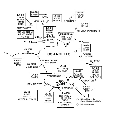
LA-04
A Great Documentary
from Brian
location
| Mt. Gleason /Palmdale
|
from Jeff Lovelace Feb 16, 2015 -
IFC, and Launcher were removed a few years after deactivation.
Due to the Station fire that happened in 2009, LA-04 is all gone.
The fire tore through there and got it all. The admin barracks were
being used by the Calif. Dept. of Prisons as a fire camp.
Two of the either LAFD or CDF firefighters were killed, just outside of the
camp, when they drove off a drop off in the smoke.
It also got the Mill Creek ranger station, six miles East of Gleason.
Made me sad, I had some pleasant memories of my time stationed at LA-04.
Down the way, towards La Canada the Hidden Springs Caf? was also consumed.
I used to stop there for chili and ice tea.
Jeff Lovelace, Generator operator IFC area, 1970-71
C - Mount Gleason, 9.8 W Mill Creek Forest Station ((P) abandoned)
[{"Tim"} I found the radar location, nothing there.
It looks like the area is being replanted with pines. The barracks is LA County fire camp. ]
L - Mount Gleason, 6.8 W Mill Creek Forest Station ((P) Los Angeles County
prison camp)
|
| LA-09 | Mt. Disappointment
/Barley Flats
|
[{Devine, B} April 9, 2020 - Brian sent 4 pictures of some some abandoned buildings -
likely before the fire?
Nov 9, 2012 -
Someone told me that Mt. Gleason was the only site in US with pitched roofs, you can see that that was
not true. A fellow lover of this site painted the USAF stuff to deter vandalism as best he could. I
never met him.
There was a man that stopped by when the caretaker was there about five years ago or so. He was in tears with his
memories, said he had served there as a Nike vet during its operation, but the caretaker at that time was hispanic,
and didnt understand the magnitude of what was happening in front of him. The caretaker told me of this first hand.
The caretaker was dismissed a year or two later, as I think drug gangs were starting to visit him, the area, or both.
Just before he was dismissed, a mountain lion killed one of his dogs there. He warned the Sherriff that if the Cat
came back he would shoot it. They told him he couldnt do that. But the cat came back for his remaining dog,
and he shot it. He told me that the vet bill was 2000 dollars, but the dog lived. They didnt charge him with a crime after all, he said.
Following this, I asked to move there weekends, and do maintainence as a volunteer as by now I had fallen in love
with the ideas for the place, and was turned down. I asked then to at least be allowed to clear the wood fuels
from nearby, and bought a chainsaw for this hope, but was not allowed to. I protested that the place was in danger of burning in a forest fire, being a vet of this myself, but it had no effect.
I still wonder that fire was set up specifically to burn this place and Mt. Gleason. After Mt. Gleason site burned, and two rangers died there, the fire was suddenly brought under control on the spot.
How convenient. B
Dec 11, 2009 -
"I met with the District Ranger for LA 9L and A. I wanted to get up there past the
5 000 dollar fine for illegal entry to photograph the apparent remains of LA 9, burned
in the fire of this year. I have not been able to do so, snow is now falling.
I understand though that they have secured funding to destroy the site immeiately.
I find this interesting. They had no money to perfect and maintain the site when it
was whole, but have many times that money to destroy it. Brian"
Oct 1, 2010 "I am still trying to get up to Barley Flats Nike site before whats left
is destroyed. Might take help from a congressman. They seem to be blocking on the
grounds of safety. Im not sure I buy it. "]
C - Mt. Disappointment ((P) radio relay site)
L - Barley Flats. 4 N Angeles Crest Hwy ((P)LA County Sheriff Air Station)
[{wishes to be anonomous} (Jan 2017) Has something changed...or is it that they don't want
anyone to know they are using the base..as a county staging base.
It used to be that the rescue teams and rescue choppers used barley
flats as a summer hang out..... so they could get to rescues in 10
minutes instead of 30-40 minutes from Long Beach airport.
The nike missile silo makes the perfect heavy helo pads.
When i was there in about 07 or 08.... the barracks were in pristine
condition and was actively being used by the County rescue. ]
[{Devine, B} Oct 2009, LA 9L and A burned down in the Angeles
National Forest Station fire. I am told only one building was saved. ]
[(Murdock, S) GPS=34-16-42 118-04-32 ]
|
| LA-14 | South El Monte
| C - 3600 Workman Mill Rd ((O) radio relay site)
L - 1201 Potrero Rd. ((P) LA County parks workyard)
[(Murdock, S) GPS=34-02-37 118-03-32 ]
[{Kamienski, R}
(via Dean.Willoughby@usarc-emh2.army.mil Feb 2001) I explored the
El Monte launcher area. Magazine elevator pit has water up to the brim.
Otherwise, it could be restored with a lot of effort. It is in a
city construction yard next to a park. A good location for a war museum. ]
A - ((P) USAR Center)
|
| LA-29 | Brea/ Puente Hills
| C - Site Dr, off Central Ave, N of Brea Blvd ((O) Shell Oil Company; oil field)
[{Kilian, R} Jan 2016, I grew up within walking distance
of LA-29 and explored it extensively. The MTR and TTR towers/pads are gone now.
Must have been removed some time in the past few months (my mom lives directly
below what was the IFC site; you could see the MTR/TTR pads/towers from her house,
noticed during a visit a couple weeks ago that they are no longer present).
[{Kamienski, R} This Nike site is currently (August 2000)
being destroyed, ]
[annotated image 47 K bytes, by Rick, who also says
"the closest public street (Vantage Point) ends in a gate with the water districts
sign on it. About half way up the hill from this gate to where the radar
installation was located is a large fenced-in water tank. If you zoom out on
Terraserve it shows as a white circle north of the site toward the housing tract
(that in the 1995 photo looks to be under construction)."]
L - Site Dr, off Cenntral Ave, N of Brea Blvd ((O) Shell Oil Company; oil field)
[{Kamienski, R}
annotated image 72 K bytes, by Rick
[{Kamienski, R}
(via Dean.Willoughby@usarc-emh2.army.mil Feb 2001)
The launcher area is now a flat dirt area. Magazines completely removed.
They worked on this for about 3 months. I got a few low resolution pictures
if your interested. ]
|
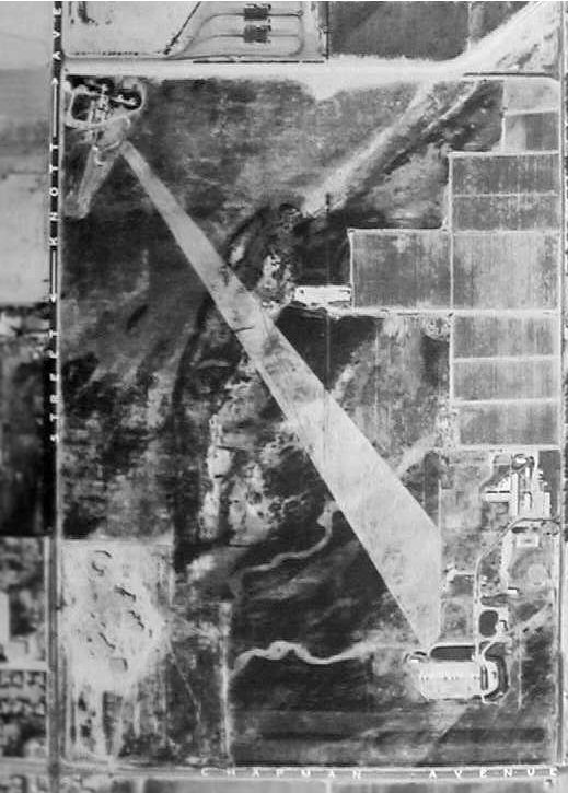
| LA-32 | Garden Grove
| SE corner Knott & Peterson ((O) industrial park)
[{Maxey, G} - picture
Was doing research on LA-78 Malibu site and came across
this picture that shows LA-32 very clearly.
Since LA-32 was destroyed before any of the current Terra Server images,
thought you might like to see it.
The original caption dated it as 1965, which means the site had been converted
to Herc. If you look closely you see the HIPAR dome in the upper left corner of
the IFC. This is correct, because I grew up in this area and actually saw the
site when it was in operation. ]
L - 11751 Western Ave ((P) CAArNG; 485th MASH)
[{Page, T} June 2007 - I have been revisiting the U.S. Nike Missile sites in
"Google Earth" aerial imagery, and discovered that part of LA-32L is still intact. Go to 33?47'33.85"N,
118?00'09.07"W to see the T-shaped building that is seen in the vintage aerial photo at
http://ed-thelen.org/LA-32-G-Maxey.jpg (the launch battery is in the lower right corner). ]
[{Snowberg, P}
(stanton {garden grove}, obliterated) ]
|
| LA-40 | Long Beach Airport
/Lakewood
| C - SW Spring & Clark ((O) Hotel and commercial development)
L - SW Spring & Lakewood ((I) CAArNG center)
[{Hiscox, George} September 2007 - Long after runway 30 was built, the
old missile battery was used by the City of Long Beach for an EOC until almost 1980. The launch doors were covered over with mounds of
asphalt covered dirt, but the facility remained accessible from a small blockhouse leading to a long steep stairway. There was a
second point of egress via a vertical ladder to a hatch. I am a retired police sergeant from Long Beach PD and attended many training
sessions in that old facility during the late 60's and 70's. Our Air Support (helicopter) Unit was also located there and was serviced by
an above ground hanger built on the property. In 1976, Long Beach ... city manager by the name of John Dever ...
sold off the land to a developer who built a business park on the property and we lost a really great EOC facility,
complete with underground diesel storage, huge generator, kitchen and living facilities. ]
[{Snowberg, P}
(obliterated) removed for construction of runway 30 [?? see above)] ]
|
| LA-43 | Ft. MacArthur
(Upper Res
/White Point)
| Three Ft. MacArthur Nike oriented web pages
1,
2,
3
update on
preservation (page 4),
C - Battery Leary - Merriam, Upper Reservation ((I) City of LA;
Angels Gate Park, Angels Gate Cultural Center)
Fun-n-games - glimpse of site in TV show ADAM-12
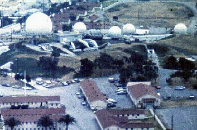
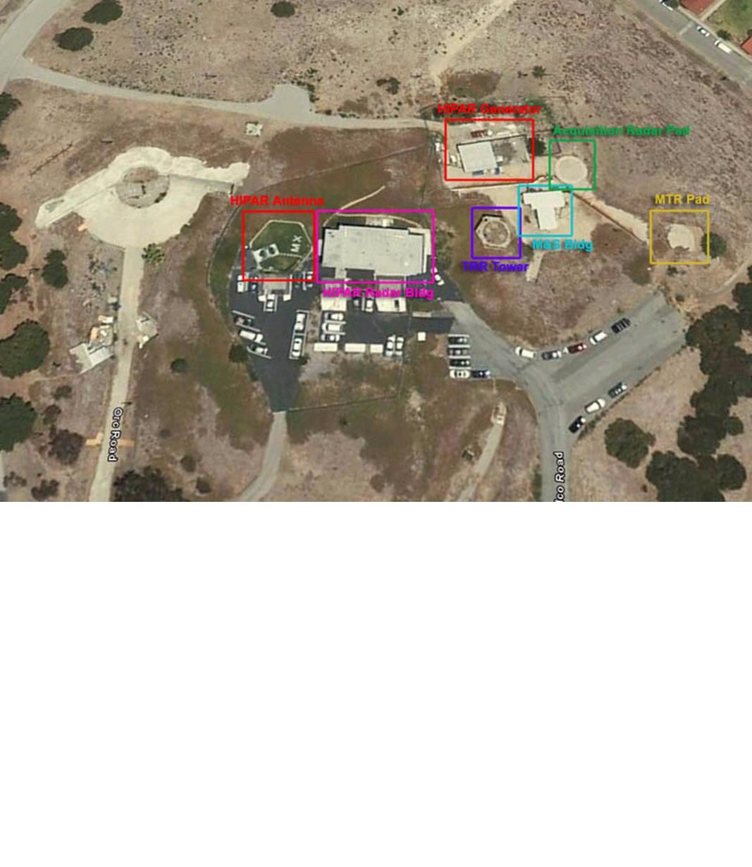
[{Janesic, J} (Jan 2008)
Old picture of Battery Leary 37 KB) the green tinted buildings are from the Nike period.
The building
in the foreground is the Maintenance and Service Building. In the background is the former HIPAR Generator Building. The same
picture shows the steel structure of the Target Ranging Radar to the left of the M&S building. Between the M&S building and
the Generator Building and on top of the original battery parapet is the pad for the MTR.
In the center of the middle picture on the page, The Marine Exchange has been expanded from the original HIPAR Building
The original building was one story and the Marine Exchange added the second. The pad for the HIPAR dome was located to
the left of this building; you can just make out the outline of the concrete foundation.
GoogleEarth image, annotated (112 KB)]
L - White Point, Below Battery No. 127 ((I) City of LA; White Point Park)
A Web Site
[{Page, T} - big image "... White Point Nike launch site, LA-43L?
A couple of structures that look like WW-II coastal artillery positions can
also be seen behind the launch strip. "
- confirmed by
Mark Morgan Yup, that's it; LA-43L Fort MacArthur (Upper)/White Point,
two B-type magazines, eight launchers, operational from 1955 through March 1974.
The Fort MacArthur Museum is hammering out a deal with the county (I think
it's the county; it may specifically be the county parks department) to preserve
and interpret the site in and around its use as a nature preserve.
According to Mark Berhow's The Harbor Defenses of Los Angeles - A
Reference Manual (San Pedro: Fort MacArthur Military Museum Association,
1992), the guns at the White Point Military Reservation were Battery Paul D.
Bunker, two 16-inch MkIIMIs, built in 1942, armed in 1944 and disarmed in
1948. The reservation also included a Post-World War I AA battery with two
3-inchers on pedestal mounts (built in 1920, no word on when they came out)
and Battery 127 with four 40mms and four .50 cal machine guns.
Great photo! MK ]
|
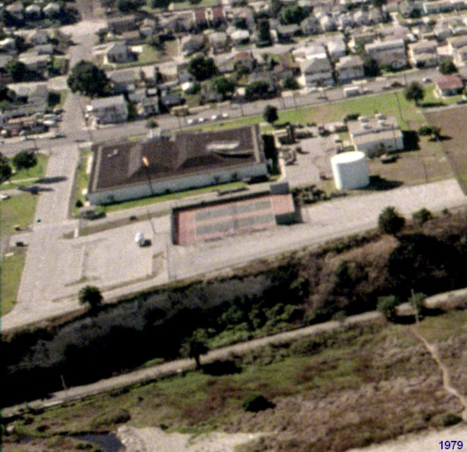
| LA-45DC | Fort MacArthur
(Lower Res) | AADCP
Nike Missile-Master AN/FSG-1
Missile Mentor AN/FPS-27
- long-range radar installation (which was shared with the Air Force
and the FAA) at San Pedro Hill AFS.
LOC: Pacific Ave. between 22d and 36th Streets
CUR: Los Angeles AFB Annex: housing/support activities
More details at Radomes.org
[{Page, T} (Jan 2008) Found at the California Coastline website, http://www.californiacoastline.org/, image 7951043, dated October 1979. The enclosed image was cropped from the large one.
The Ft. MacArthur Missile-Master building (130 KB) would be torn down a few years later (~mid 1980's) to make room for Air Force housing for Los Angeles AFS (now AFB). ]
|
| LA-55 | Point Vicente (Palos Verdes)
| a web site
C - SW Crenshaw & Seacrest ((O) City of Rancho Palos Verdes; Del Cerro Park)
L - between Hawthorne & Palos Verdes; Dr. ((I)City of Rancho Palos Verdes;
city hall/admin
|
| LA-57 | Redondo Beach/
Torrance
| C - 1102 Camino Real ((O) City of Redondo Beach; Hopkins Wilderness Park)
L - 30940 Crenshaw Blvd ((P) City of Torrance; Torrance Airport/ Civil Air Patrol
|
| LA-70 | Hyperion
/Playa Del Rey
| C - W of Pershing, off LAX ((O) private owner)
[(Anderson, T} The IFC for LA-70 is now the Cross Creek
apartment complex.]
L - 9014 Pershing Dr ((P) Los Andeles Airport Authority
A - ((P) Jep Pets) |
| LA-73 | Playa Del Rey
/LAX
| C - Manchester Ave & Redlands ((O) commercial/resdential
L - *Shared launch/admin facility with LA-70
[(Anderson, T} ... launcher area for LA70 and LA73 was
destroyed/obliterated in the early 1990's when Westchester Parkway was constructed.
The administration area is currently Jets Pets. The flat roofed buildings are
painted white and blue, but on some missed spots you can see the original green.
A double insignia sign sits on the side of the area. It is badly weathered but
you can make out" AAA" and "CAARNG" as well as the California bear. These cone
shaped signs are all that remains untouched and they are surrounded by barb wire
(thank God). It sucks to see how quickly LA can swallow up such history. ]
|
| LA-78 | Malibu
|
Nike in Movies - Mark Ferguson wrote
"LA site in Malibu, was used in the movie,
"Escape from the Planet of the Apes". You can see a Deuce and a half rolling out of the
admin main gate and the mess hall was used for the "Hospital" in the movie.
Also, there is an episode of Mannix, where they run around a HiPar dome, that was in the IFC area."
C - [at the end of Saddle Peak Rd] ((O) National Park Service,
Santa Monica Mountains NRA
June 11, 2007 - a concensus seems formed between all concerned - based on all preceeding and two more images.
from Page, T June 11, 2007 1:19 PM to 12 people
| Update -- Based upon the vintage photos at
http://george.smugmug.com/gallery/418537/1/16759653#16759659,
[local copy]
as well as the elevation data on "Google Earth,"
the LA-78 IFC site must have been at either location A, B, or C
as depicted in the enclosed image file.
All things considered, I'd now have to say that location C seems to
be the most likely spot. If correct, then all Nike structures have been removed.
Who agrees? Who disagrees? Comments are invited. (I just want to get it right.) Thanks once again.
|
from Doyle Piland,
June 11, 2007 1:52 PM to the same 12 people
| Yes, C is the location that everyone agreed upon. This included 4 or 5 people who had been stationed at LA-78 IFC
and included Col. George Evans, who put up the smugmug.com photos. Col. Evans was battery commander of LA-78 as a Captain.
Plus, if you look at the directions contained in the USGS information I referred to, you will see that the directions to
the "Nike Site" lead you to the "Easterly" peak of two peaks of the Saddle Peak. "C" is also the locations for the Lat-Lons
in the first four USGS documents. You will also note that A and C are essentially the same altitude, while B is somewhat lower.
Those stationed there indicated that on the way to and from their site, they passed the FAA radar on the other peak.
They also said their IFC was the end of the road.
So, all these things lead everyone that was dealing with it at the time to conclude that the location was "C."
I think everyone would agree that all the Nike Structures have been removed. I think there may be some concrete
pads/blocks there from what the USGS documents show as having their markers in them.
|
|
Dec 2004 - there has been an intensive discussion among the
Terrraservants
;-) and Doyle Piland including exchanges of old site pictures. The information
below from Hirose seems correct and a listing from a 4th person, whose
e-mail address no longer works, has been removed from here.
[{Hirose, P}When I click to view the Saddle Peak portion
of the installation and overlay the coordinate grid on the image, the numbers
are consistent
with Oat Mountain. That's about 18 miles from Saddle Peak.
Using the coordinates from National Geodetic Survey records, the
location of the old radar platform is about 150 meters northwest of
center in this image: See:
http://www.ngs.noaa.gov/cgi-bin/ds2.prl?retrieval_type=by_pid&PID=EW7447
http://www.ngs.noaa.gov/cgi-bin/ds2.prl?retrieval_type=by_pid&PID=EW6472
http://www.ngs.noaa.gov/cgi-bin/ds2.prl?retrieval_type=by_pid&PID=EW4145
http://www.ngs.noaa.gov/cgi-bin/ds2.prl?retrieval_type=by_pid&PID=EW4144
http://www.ngs.noaa.gov/cgi-bin/ds2.prl?retrieval_type=by_pid&PID=EW6471
The first mark is on the old radar platform at 34-04-42 118-39-21.
The last point is on the neighboring peak, but is interesting because
the 1959 description mentions a sign to the Nike site and a roadside
phone where surveyors would have to call to get clearance to proceed. ]
L - 1900 Rambla Pacifica ((I)National Park Service, Santa Monica Mountaions NRA;
LA County Fire Camp No. 8
[{Hirose, P}The image of the other half of LA-78, the
launcher area, does appear to be correct. If you bring up these datasheets:
http://www.ngs.noaa.gov/cgi-bin/ds2.prl?retrieval_type=by_pid&PID=EW6827
http://www.ngs.noaa.gov/cgi-bin/ds2.prl?retrieval_type=by_pid&PID=EW6828
http://www.ngs.noaa.gov/cgi-bin/ds2.prl?retrieval_type=by_pid&PID=EW6829
they all describe survey marks set in the former launch area. The
average coordinates are 34-03-36 118-38-47. ]
|
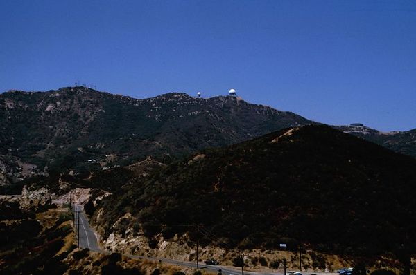
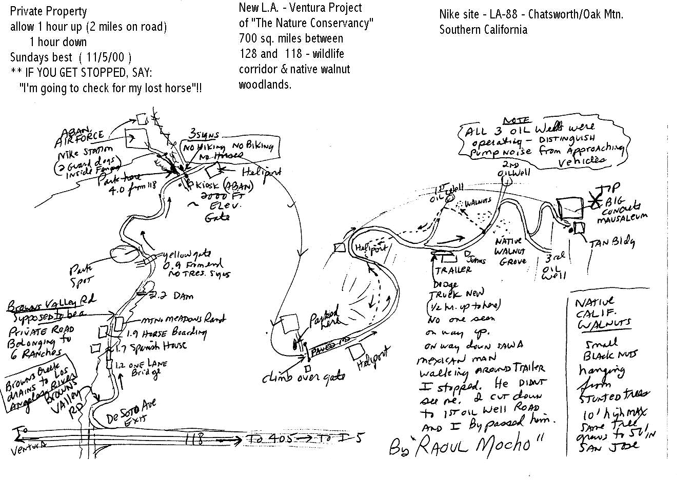
| LA-88 | Chatsworth/
Oat Mtn.
|
2022 - LA88 - Chatsworth History
from Greg Brown
More from Greg Brown - July 17, 2021
[{Brown, G} (Aug 2019) sent the following to LA Parks department (in 2015)
and the Chatsworth Historical Society in 2019
LA-Site 88, 16100 Browns Canyon Road, Chatsworth California
An attractive nuisance.
When the US Army abandoned the LA-88 Nike Missile site, they sold the property
to the State of California
for $1.00. The State used the property as a California Conservation Corps Camp for a dozen years. Then
the State turned over the property to Los Angeles County, which used the launcher area as a Sheriffs
training facility.
The many YouTube videos have been made of the site that have only attracted more people and vandalism
to the area, but the fact that this was an underground storage facility for nuclear missiles makes it
a public safety danger.
The underground storage areas have deep sump pits and present fall hazards along with rodents and snakes.
The LA-88 Launcher area should be completely demolished and the underground missile magazines
demolished, or filled with sand.
The Vault access doors welded shut, or completely leveled and the remaining buildings leveled,
and the whole area returned to the original pristine condition that it was found in before 1956.
Los Angeles County has not been a good steward of the property, Nor the LA County Sheriffs who
used the area as a training facility and left it trashed, along with an abandoned school bus
on the site that is an eyesore and a public safety nuisance.
The US Army also shares responsibility for any environmental damage that occurred during the
operation of the Base, formerly known as Battery C, 4th Battalion, 65th Air Defense Artillery,
LA-88, Los Angeles Defense, from 1956 to 1974.
This was a former military installation. There were 120 personnel stationed there for a 20 year
period, and was our First generation missile defense system.
Please honor the veterans like myself who served there and clean up the broken down graffiti
covered ruins that one was a proud component of the cold war.
Respectfully yours,
Greg Brown, former Nike Hercules Missile Crewman, LA-88, 1969-1971
|
also see
https://abc7.com/video-man-rescued-after-40-foot-fall-in-abandoned-military-base/4193296/
[{Stokes, S} (Feb 2013)
"depressing news" newspaper article
a movie ??,
interesting history spotted by Thomas Page, site identified by Mark Morgan
Foster, R (April 2005) The new parkland doesn't go all the way up
to the IFC, the parkland doesn't reach the ridge of Oat Mountain and doesn't go far enough
east to get you there. A map of the parkland can be found
here. The IFC is dead south of
the L in trail in 'Rim of the Valley Trail'.
The IFC site currently houses several gov't radio tenants including the county of
Los Angeles (And a few federale's). ]
Rollins, B (March 2005) LA-88 Oat Mountain Nike site now sits in
the middle of the newly created Michael D. Antonovich Regional Park. You can legally
drive right up Browns Canyon right up to the area outside the launch pad. Although LAPD
still keeps the gates locked to the barracks and the launch pad, the surrounding area
is apparently open to the public. From what I've heard this new public park continues
all the way up to the IFC at the top of the mountain.
There is a gate on Browns Canyon Road north of the launch area that was locked with
a sign that said closed due to the weather. Apparently, when it isn't raining this gate
is open and you can drive right up to the top of the mountain.
There are still a lot of "No Trespassing" and "Private Road" signs all the way up
Browns Canyon but they have taken down the ones on park property. ]
[{Hawkins, J} (October 2003)
Dude In The White Truck who keeps running off the people from Oat Mountain.
http://www.mybikesite.com/socal/trails/oat_mountain.htm Joe Hawkins
www.vaq34.com/ccc
[{Daemke, A} (February 2003)
Anthony said "This specific building does go down one level.
If you take the stairs 20 or so feet to the bottom, it is a big
empty room with an escape tunnel that climbs the the escape hatch."
I (Ed Thelen) said "I will bet you a nice lunch that the building you
are talking about is not part of a Nike firing battery :-))"
And Anthony said "You owe me a nice lunch! Just kidding."
Actually, after one of my trips to the Nike LA / Admin / Launch sites, I
went the the Laguna Niguel National Archives and did research on the Nike
LA-88. I found 66 or so pages of documents about the site. That building is
Nike Building number 302. It is the IFC Oper Fac room / fallout shelter. 303
is the Generator room, 304 is the ready room, 307 is the Hipar, 308 is the
Hipar Radar tower and 309 is the tracking tower. Also 300 is the Senry Box.
I also have all the specifications on the square feet, and matieriel used in
construction on the IFC/LA/Admin areas. If you would like me to give you the
information, please let me know and I will email if over to you. I have lots
on information on the LA-88 site if you would ever like to get a cup of
coffee and take a look, let me know. I am in Northridge CA, 91325 " ]
[{Daemke, A} (July 2002)
I hiked six miles to the IFC. All the buildings remain intact. The electric room
remains with all of the original electric boxes etc. Also, the bathroom remains
along with the old rusted to nothing water heater. An interesting point is this.
In one of the buildings, there is a HUGE steel door. Almost like a bank vault.
Of coarse it was open so I went it. Everything is still there but it was dark
and hard to see. Goofy me, I brought no flashlight so I could not explore
to my full potential. I also forgot a camera!!! There was also what looked like
an escape hatch that I was able to open. the ladder went down 1- or so feet
with a tunnel. Was it an escape hatch at the IFC? ]
[{Baumgartner, K} (May 2002)I have been interested
in the Southern California Nike Missle sites for many years. I live nearby
LA 88 (Chatsworth/ Oat Mountain) and have been there over the years to check on it.
As recently as early last year the site although on private property has been
easy to access,,, the buildings were in generally good shape and the magazines
were unsecured and accessible.
Minor vandalism inside the magazine had occurred as a result of apparent
teenage beer binges and campfires but most things were suprisingly undisturbed
(even the bunks). There is a man named Mr. Hiller who lives there with his
brother and father who were employed by the State as Caretakers after the
California Conservation Corps abondoned the site in 1993. As of late last
year The Los Angeles Police Department apparently leased the land to use as a
live fire range and padlocked the Magazines however I have never seen anyone
on the property except for the Hillers. I am a deputy Sheriff and I normally
check out the site weekly and I rarely see anyone there unless they are from
a filming company shooting a movie on leased land north of the site. ]
[{Moore, T} ... National Archives web site ...
a film titled "First operational Hercules Missile, Chatsworth, California".
It apparently shows "C" Battery, 551st AAA Missile Battalion in action during
a media event for the first operational NIKE Hercules missile at LA-88.
I grew up near LA-88 and know every inch of the base which, for the most part,
is still there and used by the Los Angeles Police Dept.]
C - Oat Mountain ((I) abandoned, radio/communications relay site nearby
[{Brown, G} (Oct 2016)
LA-88, where I was stationed, was an entirely new build on private property. The RC & BC
vans were inside of a concrete tilt up building, with floors at the same level as the
van doors. Very luxurious.]
L - end of Browns Canyon Rd ((I)State of California; abandoned
A hiking friend of Ed Thelen (Bill Hauser) remembers
"from freeway 118, take DeSoto exit, Brown's Valley Road, 4 miles?"
Is this a valid
hiking map to IFC or to the Launcher area?
[{Moore, T} (July 2002) The map, from what I can make
of it, shows the administration area to be basically where it says "abandoned air force NIKE Base"
with the launch areas to left of there across the access road where it says " kiosk (abandoned)
2000 ft. level gate". The left side of the map itself shows the climb to the top of Oat mountain where
the "tan building" marking notes, I believe, the remains of the IFC area now used as a radio relay
antenna site. - The L&A site is now utilized by the LAPD SWAT team for training and
I'd be careful about running around in there these days as it is not 'abandoned". ]
Administration -
[{Moore, L} (Oct 15, 2008) The Admin area of LA-88 in Chatsworth, Ca was pretty much
burned to the ground two days ago in the ?Sesnon? fire that roared through the north west San Fernando Valley.
I?ve been kind of attached to that place since I was a kid, it was hard to watch it go. ]
|
| LA-94 | Los Pinetos
/Newhall
web site
| C - LA National Forest, Contract Point ((P) ITT Gilfillon; radar test site
L - ((P) ITT Gilfillon; radar test site
[(Vadnais, E) Mar 2009 -
reasonable newspaper article
[(Kramer, C) Aug 2007 - I work for the company [ITT] that runs what was once LA-94.
We now call it Loop Canyon Test Facility.
[(Lagerstrom, S) Dec 2004 The launch area is fenced in, with a
"No Trespassing" sign, but seen from the next hill, it seems largely intact, with
three buildings standing. At the northern end of the northernmost (of 3)
launch pad a 40-foot tower (with a prominent crane for hoisting antennas
into place) has been added. Currently bears a planar-array antenna that looks a lot
like the SPS-48 that ITT Gilfillan makes for the Navy and others (e.g. Nimitz-class
carriers). http://gilfillan.itt.com/sps48.htm (I have been involved with them myself
in the Swedish Air Force) Two 40-foot containers on the concrete pad presumably
houses the rest of the radar eqp. Almost everything is painted tan. ]
[(Murdock, S) GPS=34-20-51 118-24-32 ]
A - ((P) LA County Fire Department
|
| LA-96 | Van Nuys /
Sepulveda
| C - San Vicente Mountain, off Mulholland ((P) San Vicente Mountain Park)
N 34.128666 ; W -118.512782
a number of picture links from state agencies have disappeared :-((
[{A.G.} Dec 2009 - This battery had an AN/FPS-75 ABAR.
The IFC site is partially intact in San Vicente Mountain Park,
L - 15990 Victory Blvd ((I) CAANG; 261st Combat Communications Squadron)
SMMC Stragic Plan
[{A.G.} Dec 2009 - N 34 11.100 W 118 28.996 ;
the L& A site is largely intact and is
used by the California Air National Guard. A section of the launch area is used by the
Army National Guard.
|
| LA-98 | Magic Mountain
/Lang /Saugus
| C - LA National Forest, Magic Mountain ((O) microwave relay site)
L - Lang Station, CA 14 ((P) private owner; construction company
[(Vadnais, E) Mar 2009 -
reasonable newspaper article
[{Page, T} Dec 2013 - responding to a question -
"To see the LA-98L Nike-Missile Launcher site, go to http://www.historicaerials.com/,
and search on these coordinates: 34?25'41.35"N, 118?22'29.26"W.
The years 1959, 1974, 1977, and 1978 show the launcher strips. The site was active in 1959.
Also, the LA-98C Integrated Fire Control (IFC) radar site is seen at 34?23'10.93"N, 118?19'44.03"W. "
|
| . | .
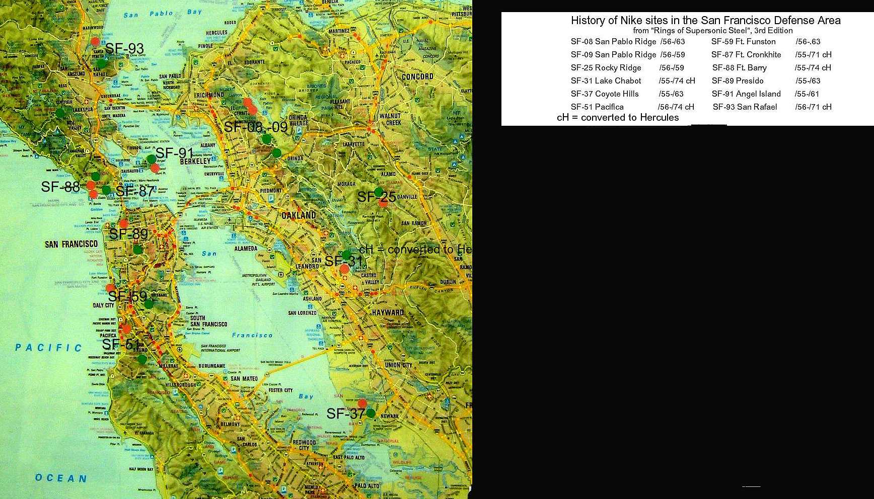
| San Francisco Bay Area
Nike Missiles by
Jeff Poskanzer
spotted by Mark Morgan |
SF-08
SF-09 | San Pablo Ridge
|
C - Nimitz Way ((O) Wildcat Canyon Regional Park)
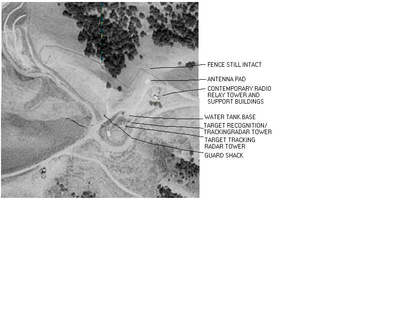
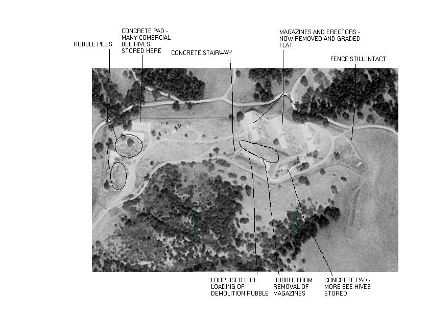
[{Page, T} July 2009 -
The official Site Map for Nike Missile site SF-08 / SF-09 193 KByte .pdf
The double IFC's (SF-08C/SF-09C) on San Pablo Ridge may be viewed at Lat 37.93932500
and Lon -122.27794722 by using the "Historic Aerials" website,
http://www.historicaerials.com/,
for the year 1959 (when Nike Missile Site SF-08 / SF-09 was active). ...
The view in 1968 shows the sites after de-activation. ]
[{Page, T} Jan 2008 - Based upon both the Army's official site drawing for
SF-08 / SF-09 and the aerial imagery for this double site, we now know with 100% certainty that
the IFC sites (as well as the launch sites) both were collocated. That is, IFC sites SF-08C and
SF-09C were side by side, and launch sites SF-08L and SF09L were side by side. ]
[{Snowberg, P} not much left except rubble.]
- Jef Poskanzer's sf08c
detailed web page,
local copy
- Jef Poskanzer's sf09c
detailed web page,
local copy
L - Nike Site Rd ((O) Wildcat Canyon Regional Park)
*shared launch site with SF-09
- Jef Poskanzer's
detailed web page,
local copy
|
| SF-25 | Rocky Ridge
|
C - 4 N Crow Canyon Rd, top of Bollinger Canyon Rd
((unk) Las Trampas Regional Park/ microwave communication site
[{Snowberg, P} end of Bollinger Canyon Rd.]
- Jef Poskanzer's
detailed web page,
local copy
L - 5 N Crow Canyon Rd, Bollinger Canyon Rd
((I) Traccor Aerospace/ Calif. Dept. of Forestry/
Las Tranpas Regional Park
- Jef Poskanzer's
detailed web page,
local copy
|
| SF-31 | Lake Chabot/
Castro Valley
| C - W of Lake Chabot ((P) communications facility)[blocked access road
starts in little parking area called
"Fairmont Ridge Staging Area"
100 yards W of intersection of Fairmont Drive and Lake Chabot Road,
0.5 mile hike on road up hill.
Buildings boarded up and locked, used for communications
- all 4 radar pads on ground, not on towers]
- Jef Poskanzer's
detailed web page,
local copy
L - SE shore of lake ((unk) East Bay Regionnal Park District;
Lake Chabot Park/ Dept of Public Safety service yard 510-881-1833)
[go up hill on road marked "17930 Lake Chabot Rd",
magazine elevator doors welded shut, buildings being maintained
and used by above agencies]
[(Murdock, S) GPS=37-43-16 122-05-56 ]
- Jef Poskanzer's
detailed web page,
local copy
|
| SF-37 | Coyote Hills/
Newark
| C - S Red Hill ((P) East Bay Rgional Park District; Coyote Hills Regional Park
/Alameda County Sheriffs Dept., radio transmitter)
[(Tyler, T) (September 2002)
IFC - 37-32.44N / 122-04.99W (Gate) Now an Alameda County public safety radio site - some
microwave relays & VHF/UHF antennas. Site is mostly intact in terms of buildings, 1.6 miles to Launch site.
3 pads, and two strange concrete tunnel shelter-type structures approx 40' long/8' wide running to
underneath two of the RADAR pads. Nice 'IFC AREA CALIFORNIA NATIONAL GUARD'
artwork on concrete berm. IFC is about 270' ASL, and has nice view of San Mateo Bridge across
the SF Bay, and salt evaporation ponds. 100 yards W of IFC gate, down hill is large covered Alameda
County Water District water reservoir, and a large, primitive shooting range, probably for PD or SO.
About 20 yards down the hill more to the N of the IFC compound is a 50'x50' fenced-in compound
that also seems to be some sort of water or sewage facility. ]
- Jef Poskanzer's
detailed web page,
local copy
L - N Red Hill ((O) Coyote Hills Regional Park
[(Page, T ) (August 2008) Map link now broken
is the final word? "Nike Trail" is presumed to skirt the former launch area on its south side.
That would put the SF-37L location right around 37?33'27.90"N, 122? 5'39.92"W.]
[(Olson, Tom ) (August 2008) [after extensive dialogs with Thomas Page; Doyle Piland;
Murdock, Scott; Mark Morgan; Mark Berhow; Sam Stokes; Ron Plante; Michael Binder]
... I have however been able to find conclusive proof of the exact location of the launcher site using archived USGS Topo maps.
The launcher are is located to the north as stated by Thomas and others. It appears that the launchers where on top of the hills.
Attached are images of the 1968 Newark 7.5 minute Quad. The site appears on the 1959, 1968, and 1973 as a military reservation.
The military designation disappears in 1980. The maps can be found at:
http://sunsite.berkeley.edu/histopo/# ]
[ A non-quote from Anonymous] - Apparently the launcher was at the top of the northernmost hill in the park,
which is just south of
the Alameda County Flood Control Channel. This is called Red Hill. There is a Coyote Hills Regional Park
visitor center which has information about the Nike Trail, which may lead to the now buried launch site at
the top of Red Hill.
[(Tyler, T) (September 2002)
LAUNCH AREA - Approx. 37-33.54N / 122-05.79W Obliterated. Launch site buildings had been
bulldozed, dumped into the magazines, magazines sealed shut, soiled over & the whole area re-graded
in the early 1970s to make it look like a natural area again, and they did a very thorough job - the only thing
I saw was an area slightly more level than the surrounding area, so I'm not 100% sure exactly where the
magazines were on this grassy hill, half a mile WNW of the Admin site. The "Nike Trail" walk goes around it,
Red Hawk Trail goes up the hill that 37L apparently was on. ]
- Jef Poskanzer's
detailed web page,
local copy
A - ((I) Coyote Hills Regional Park visitors center 510-795-9385
[(Tyler, T) (September 2002)
ADMIN AREA - 37-33.2N / 122-05.45W
Spoke with Supervisory Naturalist Paul Ferreira, who has been with the
East Bay Regional Park District ( www.ebparks.org ) since 1974. Two
former Barracks buildings, flagpole & two sets of concrete steps (Admin site had multiple up-grades)
are all that remain of admin area. Barracks are now mostly a nice visitor center, plus gift store & park offices.
Other bldgs in Admin area had trenches dug behind them, then the structures bulldozed into the trenches,
and covered over. Area is now a nice, contoured grassy area with benches, BBQ grills & picnic tables.
Prior to being obtained by the park in the 1970s, the Admin area buildings were used by the Stanford
Research Institute for marine mammal sonar research, with dolphins, etc. being stored on site in the
barracks & other buildings converted into labs/storage. ]
|
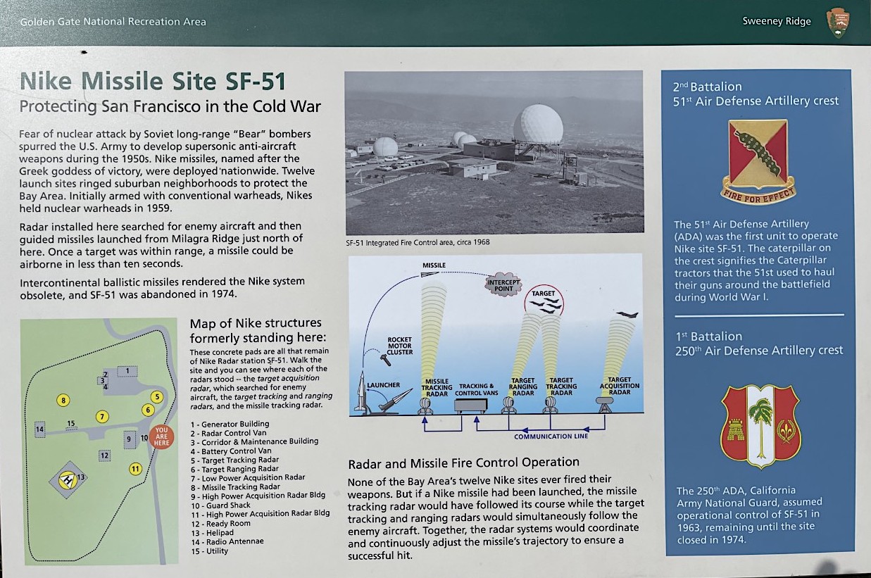
| SF-51 | Milagra
/Pacifica
NPS handout
Nike Historical Society dedication
|
C - Sweeney Ridge ((P) Golden Gate NRA; Sweeny Ridge Skyline Preserve
[{Snowberg, P} not much left except rubble. ]
[{Brown, M}
The "ready room" seemed to be a barracks, judging from the dilapidated
shower and "No smoking in bed" sign painted on the wall! There was a
lot of poison oak, and I was wearing shorts, so I didn't check out "MTR
pad" and "?". Also see
Favorite [Bike] Rides, Trip 2 - mile 33.6]
- Jef Poskanzer's
detailed web page,
local copy
L - Milagra Ridge, off Sharp Park Rd ((P) Golden Gate NRA; Milagra Ridge
[{Bruni, Frank} (Oct 2011) Well, I found the location and it is
over grown with trees, brush and the like. It is off of Sharp Park Drive and is
now called Gypsy Road. The original roads to the and through this side are still
in place and may or not take you to the launchers, IF they are still in place.
All of the original buildings located on the site appear to be gone and I can see
some remains of foundations.
- I went back into Google Earth and took another look at the area. This time I wound up where I
should have been the first time out. Save for a few concrete pads here and there, and the six inch gun
emplacement, there is nothing left of SF 51L. The original catonment area for the site is also gone
and has been replaced by what looks to be a very nice high end group of homes. The area is now
known as Milagra Ridge County Park. ]
- Jef Poskanzer's
detailed web page,
local copy
|
| SF-59 | Fort Funston/
Mt. San Bruno
|
C - Mount San Bruno, Radio Rd ((P) communications site)
- Jef Poskanzer's
detailed web page,
local copy
L - 500 Skyline Blve ((P) Golden Gate NRA; parking lot,
(www
go to "Swords to Plowshares")
[(Murdock, S) GPS=37-42-54 122-30-07 ]
- Jef Poskanzer's
detailed web page,
local copy
A - 500 Skyline Blve ((I) Golden Gate NRA; Ocean District Headquarters, Environmental
Science Center/ Air Quality Monitoring Center
*NOTE: SF-59L located near Battery Davis (2x16")
|
| SF-77H | Presidio of San Francisco
| [{Morgan, M} Headquarters site, on Kinzey at Ralston, Bldg. 1202. A large three-story building,
it was the home of the 30th Artillery group through August 1961, the 40th Brigade and the 13th Group. Current
use is apparently as offices (07 May 89). ] |
| SF-78H | Presidio of San Francisco
| [{Morgan, M} Bldg 1648, adjacent to Battery Bowman overlooking the Pacific.
It's a long single story building of newer design than the "standard" Presidio buildings. It served as headquarters of the
740th AAAMBn through September 1958, 4/61st from September 1958 to July 1959, and the CAArNG 1/250th
from 1959 until July 1974. Current occupant is the 902d Military Intelligence Group Detachment (07 May 89). |
| SF-87 | Fort Cronkhite/
Sausalito
|
C - Battery Hill 129 ((P) Golden Gate NRA;
- Jef Poskanzer's
detailed web page,
local copy
L - Bunker Rd ((I) Golden Gate NRA; Calif. Marine Mammal Center)
[{Morgan, M} Tanks holding assorted seals and the like are built
on top of the pads; one of the access doors is locked open
and I noted that the B/2/51st artwork and motto are still on
the lower door (07 May 89).]
[(Murdock, S) GPS=37-49-37 122-31-39 ]
- Jef Poskanzer's
detailed web page,
local copy
|
| SF-89 | Presidio of San Francisco (Fort Winfield Scott)
| C - Mount Suttro (Twin Peaks) ((P) TV tower)
- Jef Poskanzer's
detailed web page,
local copy
L - Battery Caulfield Rd. ((P) Golden Gate NRA (National Recreation Area))
[{Worrell, Bill} (July 12, 2011) Ed-this is an
aerial view.
Two buildings, and old Ajax launch area below and right.
[{Morgan, M} the pads abandoned and used for open air storage. The
adjacent buildings are used by an EOD unit. An Ajax site featured in Nike promotional
photos, it closed in 1963 (07 May 89). ]
- Jef Poskanzer's
detailed web page,
local copy
(T-89) Temporary site elsewhere on reservation
LOC: unknown
CUR: National Park Service Golden Gate NRA
|
SF-90DC
Mill Valley AFS
| Mount Tamalpais
| Location - Mount Tamalpias, Ridgecrest Blvd
Current - FAA JSS Facility J-33 Mill Valley, National Park Service, Golden Gate NRA
More details at Radomes.org
[{Morgan, M} above Mill Valley and San Anselmo. To get there involves a
20-mile drive up narrow, winding two-lane road, but the
view's worth it once you get to the top. The AFS was operated by the 666th Radar Squadron
from around 1951 to March 1981, and is now part of the FAA Joint Surveillance
System network. Being a remote site, the support area is huge.
Additionally, as SF-90H, the AFS was headquarters for the 40th Artillery Brigade until
June 1971, and the 13th ADA Group from July 1971 to August 1974. Equipment included
an AN/TSQ-51 Missile Mentor { August 2007 - probably never had a Missile Master} (replacing the earlier AN/FSG-1 Missile Master installation at the AADCP)
and radars FPS-7C (SLBM detection, 14th Missile Warning Squadron, Det 3) (07 May 89). ]
[{Page, T) Oh, please list the radars correctly! SLBM radar: AN/FSS-7 (formerly an AN/FPS-26
AC&W Height-finder radar) AC&W Search radar: AN/FPS-7C (later AN/FPS-107V2)
AC&W Height-finder radar: AN/FPS-90. added June 2007, It should also be noted that Mill Valley AFS never hosted a Missile Master facility. ]
- Jef Poskanzer's
detailed web page,
local copy
|
| SF-91 | Angel Island
|
Angel Island web site,
Nike page,
informal map, IFC is on top
of Mt Livermore, Launcher area is near bicycle path on south part of island.
[{Vaughn, T}(See Article)
C - Mount Caroline Livermore, Angel Island ((P) abandoned/ Angel Island
State Park)
[{Poskanzer, Jef},
detailed web page,
local copy -
News Article May 2002 "The state of California is spending nearly $300,000 to put the top back on
Angel Island. What we're talking about is the 15 feet or so that was sheared from
the top of Mount Livermore back in the 1960s to make room for a Nike missile site.
The missile site is gone -- it vanished long before the Cold War died --
but it did leave behind a road-scarred flat top of dirt stretching about three- quarters of a football field. ..."
as of August 2002 ... from the perimeter road I could see various
concrete pads up there, so it looks like the park folks kept their promise
to preserve the pads. ]
L - Fort McDowell, Angel Island ((I) closed/ Angel Island State Park)
[{Poskanzer, Jef}, - August 2002 -
The fence is 95% gone, you can just walk right in. Last time I was there,
20 years prior, I had to climb over it. Anyway, I got some great photos:
detailed web page ]
local copy
|
| SF-93 | San Rafael
|
C - top of Bayhills Dr ((P) Harry A. Bargier Memorial Park)
[{Snowberg, P} Two round ground pads, one square ground pad, and one tower
with cyclone fence around the top. Nothing else is left. Tower is a round
platform on top a cement column that is about 6 feet less in diameter
than the platform. Wonderful view of Mt. Tamalpais! Other flat areas on the road
going south must have part of the installation.]
- Jef Poskanzer's
detailed web page,
local copy
L - end of Smith Ranch Rd ((P) Marin County waste treatment plant
A tale from [Scott De La Montanya, I used to live in Contempo.
The mobile home park off of Smith Ranch Rd. This was back in '72 to '77. I was 11 to 16 years old then. We used to break
in to the ones by the treatment plant all the time. The condition of them then was like they had just removed the missiles only.
Everything else was still in there. All the controls, gauges, consoles, chairs, tracks and racks for the missiles. I remember
in the big missile sections how it would echo. But you go down a long hallway to were the consoles were and it was all
sound proofed. I think they had 3 bunkers there if I remember. 2 positively.]
[{Ricks, D} July 13, 2010 - The new water storage tank is a huge, round, white, above-ground structure at the foot
of the north end of the hill.
[{Eric} May 2008
"The plan is to put the excavated material in the vaults and just cap them," said Eric McGuire, the water
district's environmental services coordinator
[{Anton, K} Launch "pits" used for reservoirs for the waste
treatment plant]
[{Snowberg, P} Site sits on top of a small hill next to McInnis Park.
To the right of his picture is the sewage treatment plant that uses two of the three
magazines for (clean) water storage. The buildings in the center belong to the site.
Very intact and converted for some other use.]
- Jef Poskanzer's
detailed web page,
local copy
A - ((I) Youth guidance center)
|
| T-10 | Elmira
| C - 3 SE Elmira, Hay Rd ((P) low income housing)
[{Raichle, B} IFC ok, every thing there except radars not there.
[(Murdock, S) GPS 38-19-01, 121-52-22,
L - 2 S Elmira, Hay & Lewis ((I) private owner)
[{Raichle, B} expensive house next to launchers
[(Murdock, S) GPS 38-19-05, 121-53-39,
|
| T-33 | Vacaville
- Dixon/Lambie
| C Lambie Rd & Goose Haven ((P) Calif. Dept. of Health Services
/youth correctional facility)
[{Layton, J} Feb 1 7, 2015 - I work for the State of California
CALFIRE which operates an Inmate fire camp, right next to the old IFC for T-33. Sometime in
the 1970's or 1980's the Air Force gave the property to the State of California Dept of
Health Services. In 1988 CALFIRE opened up the fire camp directly next to the double fence
line surrounding the IFC. In 2002 the Dept of Health Services left the T-33 IFC site and
the property was turned over to my agency CALFIRE. In 2004 CALFIRE sold the IFC property
with all structures to the local sheep rancher. ]
[{Raichle, B} buildings there - & "Youth Correctional Training Facility"
[{Snowberg, P} (admin buildings at least. Radar pad locations unknown)
[{Murdock, S} GPS=38-13-09 121-50-49
L - Lambie Rd & Rithell Ln ((O) agricultural)
[{Raichle, B} ?fertilizer plant?
[{Snowberg, P} no sign of site, a few small buildings to the north
are oriented in the same 45 degree off North
orientation as T-10L & T-86L.]
|
| T-53 | Fairfield
- Potrero Hills
| C 2.5 SSW Travis AFB, Explosives Technology Rd ((P) Explosives Technology)
OEA Hq
[(Murdock, S) GPS 38-12-35, 121-56-38 ]
L - 2.5 S Travis AFB, Explosives Technology Rd ((P) Explosives Technology;
one elevator operational)
OEA, Inc bought the site, 2 of the 3 magazines assemble explosive charges
for air-bags, fighter ejector seats]
[(Murdock, S) GPS 38-12-14, 121-56-05 (later Potrero Hills Stor Anx, USAF)
|
| T-86 | Fairfield
/Cement Hills
| C - N Fairfield, Cement Hill ((P) private ownership)
[{McNeill, R} (April 2004) To get to the site,
you take I-80 to Fairfield (between Vallejo and Vacaville) and follow the
signs to Air Base Parkway. You will be heading towards Travis Air Force Base.
Turn left on Cement Hill Road. As soon as you make the left turn, pull off
to your right. Look up towards the hill and past an old grain silo you will
see the command elements. Look to your right and in the distance you will
see the other elements. The launcher area is where the yellow school buses
are parked. ]
[{Raichle, B} no access, no trespassing
L - N Fairfield, Air Base Parkway ((I) Solano County Detention Center
/Solano County Animal Shelter / Suisun Unified School)
[{Raichle, B} bus parking lot, Nike Administrative Area buildings
intact, poor repair]
|
Where San Francisco Nike site maps
might be
|
When Presidio of San Francisco (PSF) was an active base, right across the street from Crissy Field,
was the post engineers office and from them I waas able to get copies of PSF and Forts Baker, Berry and Chronkite.
They had a full inventory of site maps for all of the SF Nike Sites as well as those in the vicinity of Travis AFB.
The prints were available and were not marked classified. At the point in time, they were transfered to another
agency when PSF went inactive in the mid 1990's
My guess is that they are now at the National Archives ion San Bruno,
OR at the local Corp of Engineers office in San Francisco. There is a vast wealth of information on those prints
and in cases like SF 51 and the tracker for the site at PSF, the configurations for those and all the sites is
right at hand when needed.
Frank Bruni - retgrunt03 @ msn . com
|
go to top
| . | ColoradoSprings | . |
| Designation
| General Location
| Detailed Location (Current Status) |
| . | Colorado Springs,
Colorado |
[{Davidson, Marian}
Colorado Springs was the headquarters for US ARADCOM and was on ENT Air Force Base. ENT is now an Olympic Training Center. Many of the US ARADCOM buildings still exist, but the HQ building has been demolished. The streets surrounding Ent are Boulder Ave., N. Meade, E. Monument and Union Blvd.
|
go to top
| BR-04 | Ansonia
| Photos Active Army 1963-1964,
National Guard,
Main Site
(new URL) - by Anthony D'Amato
C - Airport, N of Ford ((I)US Forest Service Insect & Disease Lab)
[{Murdock, S} GPS=41-20-24 73-02-42 ]
[{Foster, M} Dec 2018,
Unable to enter gate locked. Looks occupied. Nice brass plaque at entrance signifying importance of site. ]
L - Osborne Ln & Deerfield ((P) Copper Ridge Farm; private owner)
[{Foster, M} Dec 2018,
Barracks now 4 family residence. Assy Bld and generator bldg now horse stables. Warhead assy bldg demolished and
turned into a paddock. Sentry bldg for launch area now holds horse bridles etc.
[{Make, B} converted for horse farm use and up for sale. ]
Most buildings
still there, launch magazines filled. Horses occupy the Assembly building : )
also this is the only site in CT that I have seen a bunker in. At first I thought
it was a farm add-on, but it poured 2 foot thick walls and a L-turned
doorway, with steel door gave it away. I wish I had plans for it or could have
gotten inside : )]
[{Murdock, S} GPS=41-21-02 73-02-57
]
|
| BR-15 | West Haven
| C - US 1, March Hill ((P) Orange ANGS; CTANG 103d ACS
[{Murdock, S}GPS=41-16-05, 72-59-31, (later known as
Orange ANGS, USAF):
]
[{Bender, D} The partially intact IFC Area is used by
the CTANG as an
Aircraft Control & Warning site. In place of the Nike Ajax
acquisition radar, a modern 3-dimensional TPS-75 radar is
now in use here. An Operations Module, the modern
equivalent of a Nike control trailer, is attached to the
original Nike system Interconnecting Corridor. The Administrative
Area also remains largely intact at this site. ]
L - Bull Hill Ln ((P) Town of West Haven Park & Rec Dept; Nike Site Park
[{Murdock, S}GPS=41-16-19, 72-58-45,
] |
| BR-17 | Milford
| C - Eels Hill Rd, N of Rt 162 (P)Town of Milford Board of Education
[{Abbazia, E} June 2010, with Eric Muth,
Helipad, generator room, radar blocks, flag pole, target and simulator vans.
{likely pads, not vans? ;-)) }
barracks, BOQ, CQ.
We were able to get inside the old pump house and saw a 200 - 400 gallon water tank,
shut off valves etc. Guard shack is still there. Saw whats left of the Day room,
Admin office, Barber shop, medic, club, and Mess hall.
We met a member of the American Amateur Radio League who talked about a steel door
"bunker" 30 feet beyond the rear of the mess hall. Weeds, trees and overgrown stuff
prevented us from photographing it until maybe November when we will hack it with a machete.
I am looking for the LxW sizes of the buildings like the barracks.]
[{Murdock, S} GPS= 41-13-43 73-00-57,
]
L - Rock Rd near Quirk ((O) industrial park)
[{Murdock, S}GPS= 41-14-23 73-00-16,
]
|
| BR-65 | Fairfield
| C - One Rod Hwy, off Reef (Town of Fairfield; fire training and canine center
[{Murdock, S} GPS=41-07-43 73-15-01
]
L - Old Dam Rd, off Pine Creek (South Pine Creek Park)
[{Murdock, S} GPS=41-07-29 73-15-49
]
A - [{Miner, M} The motivation for the article is that the
housing area which after the army used it during the NIKE days, the Navy bought
and military personal from various services, mostly recruiters have been living
there since the late 1980s. The Navy is selling it and the town will
close on the sale soon. The houses will be sold for low cost housing. ]
|
| BR-73 | Westport
| C -Bayberry Lane at Merritt Pkwy (... Westport/Weston Health District;
Bayberry Spec Ed Center
[{Wright, D} (Nov 2010) The buildings at the top of the mountain
(3-acres) are leased from the town by the Westport Astronomical Society, a local astronomy club.
The remaining buildings at the top of the site have been restored and are used by as a
(1) classroom, (2) office/library, and (3) one of the remaining two 40-ft radar towers
is equipped with an observatory dome and a 16" Meade LX-200 reflecting telescope. ...
The site is one of the highest and darkest sites within the Town and Westport, and
really makes good use of the former radar site. We are on the Web at
www.was-ct.org.
For recorded info/message, please contact us at 203-227-0925 or email WAS at
wasrolnick@gmail.com
[{Ojarovsky, J} The buildings at the top of the mountain
(3-acres) are leased from the town by
the Westport Astronomical Society, a local astronomy club. The remaining
buildings at the top of the site have been restored and are used by us as a
(1) classroom, (2) office/library, and (3) one of the remaining two 40-ft
radar towers is equipped with an observatory dome and a 12.5" reflecting
telescope. ...
The site is one of the highest and darkest sites within the Town and
Westport, and really makes good use of the former radar site. We are on the
Web at WWW.WAS.VISIONNET.COM. For recorded info/message, please contact us
at 203-227-0925. ]
[{Murdock, S} GPS=41-10-16 73-19-42
]
L - 85 North Ave (Firefighter training center)
School Expansion
[{Ojarovsky, J} As of 11/99, construction crews were in the
process of demolishing the entire above ground buildings to make room for
the expansion of the public Staples High School. ]
[{Murdock, S} GPS=41-09-34 73-19-52
] |
| BR-94 | Shelton
| C - Eagle Dr extension (US Gov; storage and maint support for Ft Devens)
[{Murdock, S} GPS=41-19-40 73-11-01
]
[{Foster, M} Dec 2018,
Now a city park. Admin blogs being used for day care. Generator building converted to grandstand generator building
also being reutilized.
L -
[{Murdock, S} GPS=41-18-28 73-10-21
]
[{Foster, M} Dec 2018,
Unable to access site due to locked gate. Now owned by Jones Tree Farms. From what I could see most
admin buildings in good condition.
Housing -
[{Murdock, S} GPS=41-19-30 73-10-56
]
|
| HA-08 | East Windsor
/Warehouse Point
| C - Scantic Rd (US Government)
[{Foster, M} Dec 2018,
Totally demolished, no a trace of occupation other than paved entrance road. Appears to be slated for
residential development. Interesting thing about this site is that it is on a slight rise in the
Ct River valley. This site also was a late to close and HIPAR site. Not much of a radar horizon,
wonder why this site lasted as long as it did. Possibly Westover AFB, 8th AF HQ? ]
[(Griswold, S) Jan 30, 2010 - no-longer US Government. Now 'New Testament
Church'. there is now a cross in the middle of the radar column. viewable on both Microsoft/Bing maps
in the birds-eye view, and just barely visible if you go by the street view on GoogleMaps. ]
[{Murdock, S} GPS 41-52-13, 72-35-39
]
L - Phelps Rd (USAR Center)
[{Murdock, S} GPS 41-53-27, 72-36-13
]
[{Foster, M} Dec 2018,
Heavily fenced in Army Reserve Center
|
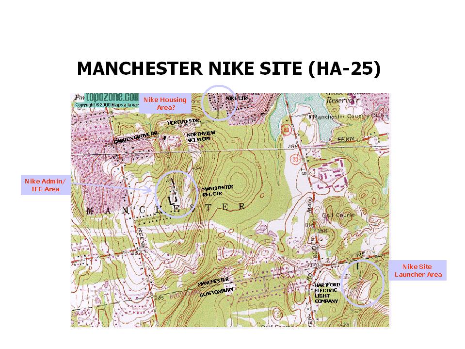
| HA-25 | Manchester
| Annotated topo map from
John McGrath, 140 K bytes.
(Temporarily here until someone (not me) more completely
documents site HA-25)
C - 110 Garden Grove Rd (Town of Manchester, Recreation Center)
of 110 Garden Grove & Hercules Drive,
seems 41N 45' 06", 72W 32' 06".
The top of the hill seems about 200 yards SE.
(A nice place for radar, but I can't see anything in the image)
[{Foster, Mark} - Jan 2019 -
This one is a real gem. Appears all buildings still exist except generator bldg. and
interconnecting corridor. This is one of the largest FC area I have ever visited. Standard
Nike layout (New England COE design) plus HQ building, HQ billeting, Orderly building,
larger than average motor pool and a large utility building that is new to me. Site
was Ajax only however had a basketball court and ball field. All buildings are well
kept up and a large sign indicate it is ?Nike Site Recreational Area?. ]
L - Line St (Hartford Electric Light Company)
of Line St. - E-W road at about 41N 44' 24", Hartford Electric
yard seems to be about 41N 44' 19", 72W 30' 58"
[{Foster, Mark} - Jan 2019 -
Barracks area is now 2 large lots with two homes. Launcher area is on hill behind homes and
neighbors indicate it still exists but is overgrown. Heavy rain prevented further exploration.]
[{McDonald, M} ... when I saw a sign for a
daycare called Nike Tykes I drove up this residential street to find the
Nike Site Recreation Area. ...
I also believe we found the
housing area - Faith Circle (Rainbow Condominiums) built in 1958. Located on the
other end of Hercules Road - road closed long ago and blocked by a guardrail
and fallen trees. ]
[{Purcell, A} Jan 2004 - ... my school (Loomis Chaffee
in Windsor) has a riflery team that I am a part of. We shoot at a range
operated by Metropolitan Shooters on the Nike housing site in Manchester.
(Our range is a few buildings over from Nike Tykes). ]
Administrative area and story
from from Mike Doherty Dec 9, 2014
|
| HA-48 | Cromwell
| C - County Squire Rd (Ronccelli Christ Church; housing for the elderly)
[{Larsen, D} (Jan 2022),
The IFC area for HA-48 has recently become 'Landon of Cromwell' luxury apartments.
All of what was left of the Nike buildings have been razed and new apartment buildings
have taken their place. Remnants of the perimeter fence line are all that remain.]
[{Foster, M} Dec 2018,
All buildings exist but are heavily vandalized one radar tower still exists.
Sign on gate indicates site will had a public hearing last month with planning board.
I would expect complete demolition in very near future.]
[(Griswold, S) (Jan 2010) - Major overgrowth, but quite
a few of the buildings, except for a metal structure on the north-east corner, are
still standing. A lot of vandal damage (graffiti, yes, but some walls smashed out,
around pipes, and to make access to other sections.) Found an open well head behind
the main water supply building (central-northern section) behind the main water tank.
A 2-foot Diameter brick lined hole.. couldn't see too far, 2 inches of ice on top of
the water, only 4 inches from top edge. (manhole ring sitting off to side, cover
location unknown). Also, sounds like water flowing into the waste treatment unit
south of the building in the south-west corner, source unknown. - posting photos to a
album on Facebook, of the recent HA-48 tour, under the folder "Cold-War Ghost Town',
taken in winter (today 01-30-2010) ]
[{Polmon, D} (Feb 2003)
... most, if not all, of the buildings of
HA-48 are still there! They are overgrown to the point
of almost not being able to access them, which
probably helps in their continued existence.
They are cement-block shells, with all the glass gone,
toilets smashed, most of the electrical wiring
stripped out, some holes in the roofs, but still there.
When I say overgrown, there is, at most, a 3-foot
path through the brush where the asphalt driveways are
-- some are completely covered over.
At one point, we were ten feet from a building,
and the only way you could tell it was there
was to see the roofline!
The flagpole still stands, as it does at the Portland (HA-36) site.
In speaking with teams that were assigned other areas
of the search, one handler said that he saw as many
as 12 "platforms" or "towers". When I asked him for
a better description, he gave me a description of
radar platforms similar to the photos of SF-88 on the website.
Most of the perimeter is surrounded by condo complexes,
which makes the site's continued existence even more
astounding. I spoke to one of the young cops who went
out with us and had grown up in the area, and he can
remember troops being there.
... My team personally searched at least 6 or 7 buildings
-- some that were obviously offices, others that had
the electrical trenches in the floors for equipment wiring,
and at least one that would have been the generator
building. One cop pointed out that they even had a jail
-- until I broke his bubble and told him that the room
with the bars on the window and door were to probably
keep people OUT, not IN! I assumed it was a storage room
for classified documents or weapons. (My Army experience
was crypto, not radar, but classified is classified!)
It is amazing to me how quickly nature reclaims abandoned
areas. There was a huge pine tree in front of one of
the buildings -- probably 30 feet high, over a foot in
diameter at the trunk -- that was probably mere landscaping
when the troops were there -- intensionally planted! ]
L - Middletown, Mile Ln (USAR center)
[{Foster, M} Dec 2018,
Admin blogs demolished. Launcher area had a relatively new but unused Army Reserve Center (labeled public
safety bldg). In front of he former admin bldg is a 50 ft long railroad bed? The local postman said it was
built by an Army railroad construction unit.
[{Polmon, Dave} (Dec 2008)
While browsing YouTube one day, I came across someone's video of the same
site taken almost two years ago, and the brush had been bush hogged. The
buildings and some of the towers can be plainly seen.
I hope that isn't a bad thing -- like the town is getting ready to do
some developing there. It could possibley just be to make it easier to
spot vandals, since it is a popular gathering place for teenagers.
Anyway, if you go to the YouTube site, on the right side there are other
videos of Nike sites -- including the one in Manchester, CT (I forgot the
designation). It shows the launch facility and what the town has done
with the former command facility (day care).
http://www.youtube.com/watch?v=anDsxaVlVTE&feature=related
[{MacDonald, John} (Oct 2003)
This area is north/west of the USAR Center on Mile Lane in Middletown,Ct.
where the launching site is listed to be located.
I found numerous flat concrete slabs and what appeared
to be a structure large enough to back two trucks into. Very heavy
vegetation and brush in this area (thorn bushes). The
area that I hiked in is off of Middle Street in the Cromwell/Middletown
area. I there any other info about the Nike site in Cromwell,Ct?. Was I
at the IFC site for HA -48 ? .No signs of solid structures except the
"two truck garage" looking structure. Lots of concrete slabs and
concrete chunks,metal piping,two inch black plastic piping,etc.Also
signs of brick and a "willow" tree in the middle of all of this near one
of the foundations.A response would be appreciated.
|
| HA-HQ | New Britain | Rocky Hill Road |
| HA-67 | Plainville
| Newspaper story spotted by Thomas Page
C - N Mountain, off Loon Lake ((O) residential)
[(Griswold, S) Jan 30, 2010 - waste treatment unit behind
one of the platforms in Plainville (HA-67), as well as two open wells close by.. One,
identical to the one seen at HA-48 (brick lined 2-foot Dia., with a pump motor visible
below the water). But another one, appeared to the 5-foot diameter opening, with a
metal plate, three destroyed pumps on top, but the access hatch (2-foot square) was wide-open.]
[{Allen, Ron} (January 2006) On top of the hill was the IFC site,
it consisted of a generator building the IFC building with the two trailers and the three
radars. ]
[{Samek, R} The site is actually on the
small mountain, with housing at the base of the mountain. I got there by
driving up Metacomet Road and then I saw a path through the woods that
led to the mountain. A couple of dirt bikers told me the site was up the
mountain, maybe a 15-minute walk, which was just about right. Judging
from my examination of the site, it appears the main road to the Nike
site came from the opposite side. I remember as a child seeing a U.S.
Army sign on the main road, that probably was the entrance to the site.
But that road (and sign) is long gone and the access from the original
road is probably eaten away by a quarry operation.
L -Hyde Rd off Scott Swamp (Stanley Works, Magic Door Division)
A - [{Allen, Ron} (January 2006)There were two
administrative areas, one was for HHB 1st Msl. Bn, 51st arty. It consisted
of a barracks, shop building and an administrative building with various
offices.
There was also a battery admin area, a barracks, admin. building
with offices, supply room, day room with PX and motor pool office. A mess
hall served the IFC area, the Launcher area and the Battalion Headquarters
and Headquarters Battery. ]
[{Becker, Z} (November 2002)
My friends and I would play paintball there as a kid. Its pretty much
obliterated now. Lots of concrete buildings caved in...rubble, etc.
You can still make out the parking lot with CO/CO.First Sergeant etc.
That's all that remains. ]
|
| HA-85 | Avon/Simsbury
| C - 824 Montivideo Dr. (Talcott Mountain Science Center)
[{Pellino, J} (June 2006)
Glad to say the site is fully operation - as a science center for teachers and students!
Talcott Mountain Science Center All but two of the original buildings are
refitted and in daily use as the facilities. The guard shack still stands intact (we keep the road sand
and snow shovels in there) The radar pads now support a sundial and astronomical observatories.
I'm working on a visual and text history of the use of the site, but for now our site has some photos where you can see what we've done.
-- John A. Pellino, Assistant Director, Talcott Mountain Science Center ]
L - Hilltop Dr (RWR Associates/Tower View Condominiums) |
Return to Home Page,
Return to Nike Location index
go to previous,
go to top,
go to next
If you have comments or suggestions, Send e-mail
to Ed Thelen
Updated Jan 15, 2022