| . | |
Alaska's Cold War Nuclear Shield
by Bob Raichle
Former Battery Control Officer - Echo Battery
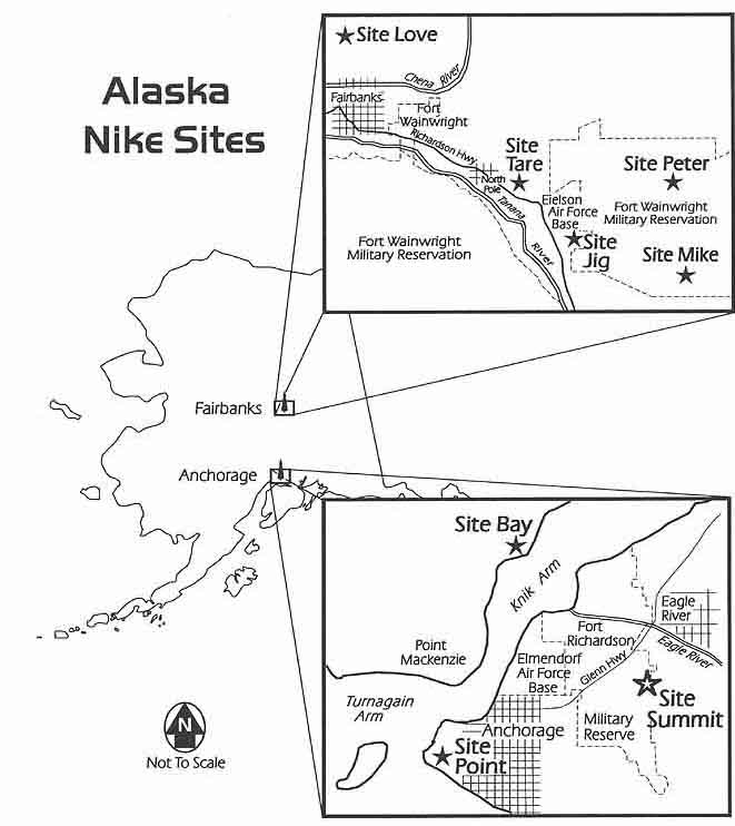
- Maps of Alaska Nike sites 56 K bytes - A YouTube of Save Site Summit Sites -
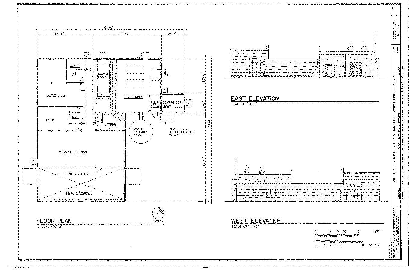
Maps of Alaska Nike sites 56 K bytes from "Site Summit - Nike Hercules Missile Installation" June 1996 Dept of Army, 600 Richardson Drive, Ft. Richardson, Alaska 99505 (907)384-3010 floorplan for the launcher building at Alpha Battery (A/2-562 ADA), in Fairbanks. - from Chris Text with document - "Library of Congress "Floor Plan; East Elevation; West Elevation - Nike Hercules Missile Battery, Tare Site, Launch Control Building, Fairbanks, Fairbanks North Star Borough, AK Digital ID: (None) hhh ak0225.sheet.00001a - http://hdl.loc.gov/loc.pnp/hhh.ak0225/sheet.00001a Reproduction Number: HAER AK-20-A (sheet 1 of 2) Repository: Library of Congress Prints and Photographs Division Washington, D.C. 20540 USA http://hdl.loc.gov/loc.pnp/pp.print " also see http://www.loc.gov/search/?q=nike+missile+battery+floor+plans |
| Designation | General Location | Detailed Location (Current Status) |
| *** | Ft. Richardson | NW Anchorage |
| *** | Ft. Wainwright, 166 Ord Co | NW Fairbanks
 from James Biles Jan 2013 -
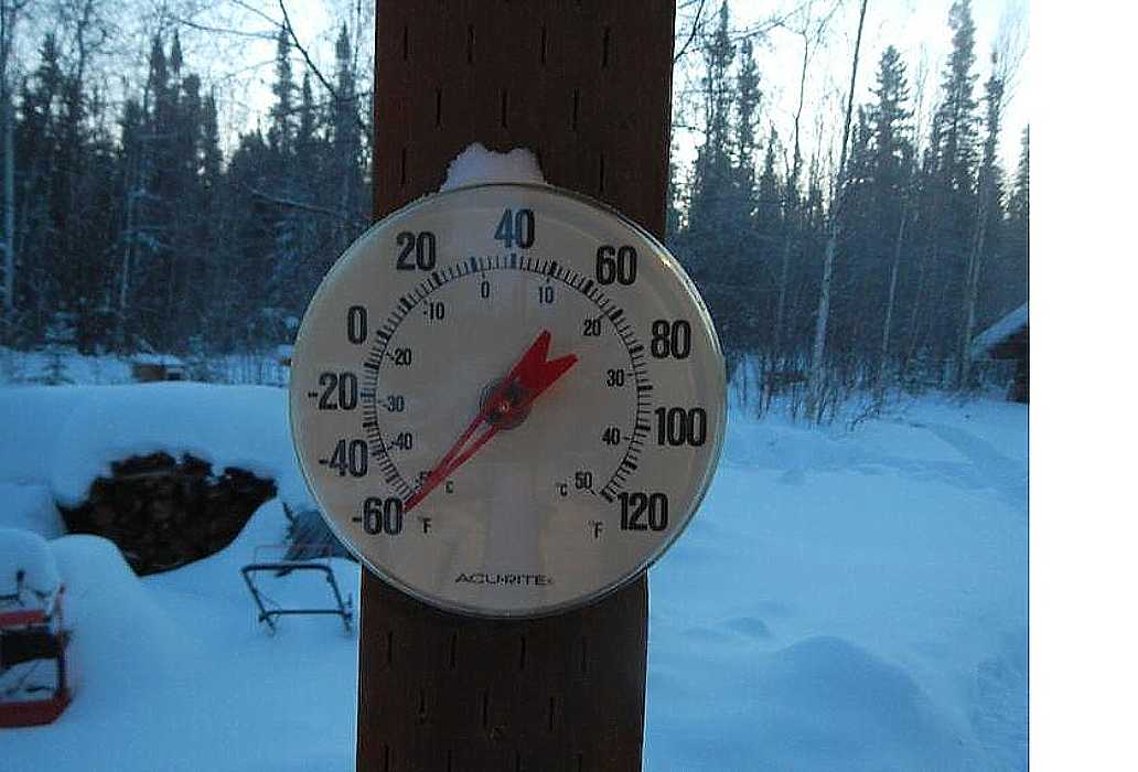
I remember 72 below zero; January 1, 1968 at North Pole, Alaska on the
way to Fort Wainwright in my personal Jeepster with two others, to attend
the Brigadier's New Year Reception under direct orders from the
Battalion XO. Unbelievable stuff happens to vehicles at that temperature.JB
from James Biles Jan 2013 -
I remember 72 below zero; January 1, 1968 at North Pole, Alaska on the
way to Fort Wainwright in my personal Jeepster with two others, to attend
the Brigadier's New Year Reception under direct orders from the
Battalion XO. Unbelievable stuff happens to vehicles at that temperature.JB
|
| PETER
B Bty /2/562d 3/59-4/71 | Fairbanks | 15 E Eielson AFB (Abandoned; US Army Yukon Training Area)
web site
[Summary of several e-mails - (August 2015)
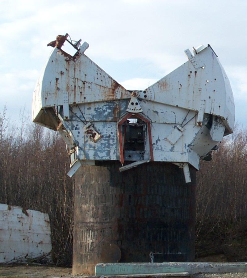
Thomas Page says "Someone must have out-of-date information. My Google Earth .kmz file has the Nike site Peter IFC site correctly pegged at 64°39'52.87"N, 146°44'17.76"W. The remaining radar platforms are clearly visible."] [{Biles, James} (Dec 2014) much of Bravo remains in skeletal form. Lots of concrete is left; the IFC (admin) building pad, and its radar towers (including clamshells), the launcher assembly building, LCT building, both launcher magazine buildings, and the warhead bunker. All of that is still standing. The ABAR tower is also still standing. [{Bollinger, J} (Oct. 2003) There was a lot of clean-up for asbestos over the summer. Most of the old buildings are just foundations pads now. Images of old Clam Shell protectors for tracking radars - Side view, Quarter view. [{Froehlich, J} (Feb. 2003) During the past several weeks, Mike and Peter sites on Eielson AFB/Ft Wainwraight have been demolished. AS of today all that remains of "B" battery are the 3 radar towers. Another reminder of the Cold War bites the dust. ]
|
| MIKE
C Bty /2/562d 3/59-4/70 | Fairbanks | 10 SE Eielson AFB (Abandoned; US Army Yukon Training Area)
web site, another web site [{Froehlich, J} (Feb. 2003) During the past several weeks, Mike and Peter sites on Eielson AFB/Ft Wainwraight have been demolished. AS of today all that remains of "B" battery are the 3 radar towers. Another reminder of the Cold War bites the dust. ]
Launcher area
We also reconned the other launch building, about 100 meters away. It still had much of the air-circulation ducting and water piping, and generally had not been as thoroughly stripped. However, the steps to the sublevel were gone. ... A word of warning to potential visitors: DO NOT attempt entry to the bunkers. It is illegal, and the bunkers ARE on a military reservation. There was a complex of 3-4 buildings, concrete/wood-frame construction, which are extensively tumbled-down. From the hinged "clamshell" doors on top, I assume these housed radar arrays. One of the towers still has the clamshell doors intact. Otherwise the site is pretty well stripped. Access to the towers is possible except for an unsupported steel ladder in one tower.
... This email is not intended
to promote visitation of the launch site.]
|
| JIG
D Bty /2/562d 3/59-4/70 | Fairbanks | 5 S Eielson AFB
web site C -((O)
L - Explosives storage
USACE
|
| TARE
A Bty /2/562d 3/59-4/71 | Fairbanks | 20 S Nenana ((O))
a-2-562 web site, nikealaska web site, drainfreak web site {Babler, Roger A} “former scope dope” [April 1007] says "On the current conditions of sites the first remark puts our site destroyed in the early 60’s “Taint SO” Know a Robert Foy he served there in 1970. FYI per the 98 anniversary edition of USA Alaska puts our site the first on operational in Alaska came on line 08:00 10 May 1959. " [{Froehlich, J} (Feb. 2003) Tare site was destroyed in the early to mid 60s. [Roger Babler suggests that "early to mid 60s" should read "early 1970s"]. It was located on Moose Creek Bluff. Mike and Peter are actually on Ft Wainwright property. ]
L - Chena River Recreation Area
|
| LOVE
E Bty /2/562d 3/59-4/71 | Fairbanks | 10 NW Fairbanks ((O) C/L)
web site USACE [{Siegfried, Bill} (added July 2015) Several of the surrounding dirt and gravel roads require 4 wheel drive, especially when wet. There was no evidence of Nike era construction to be seen. The area where I suspect the site was is totally overgrown with trees and brush. Totally obliterated. ] [{Freak} (added March 2004) completely buldozed from what I can tell. I believe this satellite photo shows the former site (I attempted to drive there and got stuck in the bad roads). ] [{Morgan, M} EWAGS on the site lat/longs: 645645/1475138 ] |
| POINT,
A Bty 4/59-4/79 | Anchorage | 10 SW Anchorage, near Anchorage International Airport
USACE - somewhere else -, a nikealaska web site, drainfreak web site,
[{Plante, Ron} (added May 2017)
Executive summary: Easy to find, all structures are intact though some have been modified.
|
| Bay Goose Bay C Bty 3/59-5/79 | Anchorage | 20 NW Anchorage, Goose Bay
nikealaska web site, drainfreak web site, [{Peterson,J} (July 2012) The control area now hosts a State correctional facility (all new) on the landing strip access, while the control bldgs are now part of a new waste-water treatment plant. Hmmmmm. ] [{Freak} (added March 2004) The IFC is mostly burned, part of the concrete structure and the bases of the radar towers are still standing, and used for paintball wars by the local kids. The launch bunkers are still intact although one is missing most of the roof. Someone has attempted to seal the lower levels of the bunkers with concrete over the door (July 2003). Photos: http://freak.minimanga.com/bay/] [{Warren, J} Btry C is located across Knik Arm at Goose Bay. The state of Alaska owns this property and used the IFC area briefly in the mid-80's as a correctional facility. The launch area has been fenced off and is in reasonably good shape. The last time I visited there, the dog pens and dog training apparatus was still there. As were the guard towers. I have a map which shows the layout of the roads and buildings, but does leave out a few explosive bunkers. ] [{Kerns, T} We had a landing strip next to the IFC area. ]
L
|
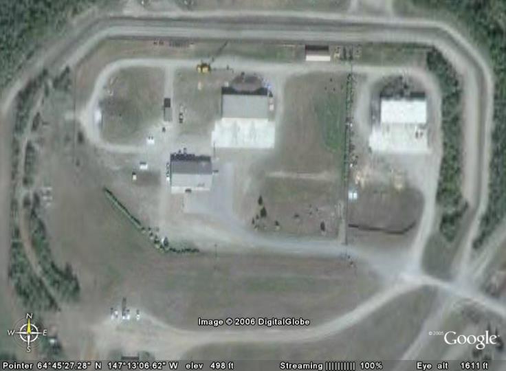
| SUMMIT,
Site B B Bty 5/59-5/79 | Anchorage | 25 miles E Anchorage, Chugach Mountains
Site Summit Handout Front, Back via Bruce Long Site Summit handout 2 MByte nikealaska web site, drainfreak IFC site, drainfreak Launcher site Friends of Nike Site SUMMIT Webpage - A YouTube of Summit
?The Army is trying to protect us from vandals
by destroying the Nike site?
Latest, another public meeting May 26, 2004 -
OK - at least they are being public about it :-))
(Bureaucracy at work for us?)
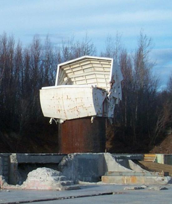
As I reached the Summit I noticed again no hipar or lopar radars as I found missing when I first viewed it from Anchorage. The windows & doors are all boarded up, the building's siding partly missing and, the tin siding on the tracking radars missing as well due to the harsh weather. The motor pool was replaced by antennas & microwave dishes. There was just basically an old empty building with many memories. There was not much to look at just my stories seemed to be all there was. I did get a peek inside the IFC area and it was all empty. The paint showed it's age and the many layers were peeling, I wondered which layer I had painted? The memories were many and I thought of all the guys who served there and wondered why it was all gone now. There was some talk about restoring it but, I wonder where the funds would come from. Perhaps the new missile program would have the best chance of it's rebirth or, maybe just knock it all down and just have a memorial built, just don't let it die.
I did go to A-Brty, it is inside a park which the Nordic Ski club runs now.
The barracks and IFC area is just a cement pad but, there was still the Abar
radar. We flew in and trained there sometimes. The launching area was now a
weight room and, children were there training in one of the bunkers where the
missiles use to lay!]
|
| Murphy Dome | Fairbanks, Alaska |
[{Smith, Larry}
Murphy Dome is about 40 miles north west of Fairbanks. You can view details on
http://murphydome.tripod.com.
The Air Force radar and computers along with input from all the radar sites plotted all the
air active in the northern Alaska airspace. The Air Force computers would compute the interception point between the Air Force fighter and
the enemy aircraft. This data from the Air Force computers was displayed on the Army radar display to determine if the interception point
was in the Nike lock on ring. If it was the Air Force Fighter would be called off and the target would be assigned to the nearest Nike
battery. This could all be done without voice commands. All data and voice was via the microwave net work called White Alice.
The southern Alaska airspace control center was Fire Island near Cook Inlet near Anchorage.
Some interesting times with the earthquake March 1964 and JFK November 1963.
Larry L Smith, Capitola, CA, 408-206-6412 |
Return to Home Page,
Return to Nike Location index
go to previous,
go to top,
go to next
If you have comments or suggestions, Send e-mail to Ed Thelen
Updated May 27, 2017